Bogève (Bogève)

- commune in Haute-Savoie, France
 Hiking in Bogève
Bogève, a picturesque village located in the Haute-Savoie region of France, offers stunning hiking opportunities amidst the French Alps. The area is known for its rich natural beauty, characterized by rolling hills, lush forests, and breathtaking mountain views.
Popular Hiking Trails in Bogève:
-
Les Crêtets Path: This scenic trail leads you through beautiful pastures and forests, offering panoramic views of Mont Blanc and the surrounding peaks. It’s suitable for hikers of all levels.
-
Parcours des Gorges du Fier: A bit further afield, this trail takes you to the stunning gorges of the Fier River. The path is well-marked and showcases impressive geological formations and lush forested areas.
-
The Col de la Balme: For more experienced hikers, this trail climbs to a mountain pass that provides spectacular views. The ascent is challenging but rewarding with the sight of distant mountain ranges.
Tips for Hiking in Bogève:
- Check the Weather: The weather can change quickly in the mountains, so always check the forecast before heading out.
- Proper Gear: Wear sturdy hiking boots and weather-appropriate clothing. Consider bringing trekking poles for stability on uneven terrain.
- Stay Hydrated: Bring plenty of water and snacks to keep your energy levels up during your hike.
- Respect Nature: Follow Leave No Trace principles by staying on marked trails and taking all your rubbish with you.
Best Time to Hike:
The hiking season in Bogève typically runs from late spring to early autumn (May to September), when the weather is most favorable and trails are accessible. However, some trails may be covered in snow during the early spring months, so always verify trail conditions beforehand.
Local Attractions:
After a day of hiking, consider exploring the charming village of Bogève, where you can sample local Savoyard cuisine and enjoy the cozy atmosphere.
Whether you're a beginner or an experienced hiker, Bogève offers an array of trails that cater to all skill levels, making it a great destination for outdoor enthusiasts seeking adventure in the Alps.
- Country:

- Postal Code: 74250
- Coordinates: 46° 11' 33" N, 6° 25' 47" E


- GPS tracks (wikiloc): [Link]
- Area: 7 sq km
- Population: 1046
- Wikipedia en: wiki(en)
- Wikipedia: wiki(fr)
- Wikidata storage: Wikidata: Q501916
- Wikipedia Commons Category: [Link]
- Freebase ID: [/m/03nty0n]
- GeoNames ID: Alt: [6451021]
- SIREN number: [217400381]
- BnF ID: [15274298q]
- INSEE municipality code: 74038
Shares border with regions:


Boëge
- commune in Haute-Savoie, France
Hiking in Boëge
Boëge is a charming commune located in the Haute-Savoie region of the French Alps, offering beautiful landscapes and a variety of hiking options. The area is characterized by its picturesque mountain views, lush forests, and tranquil lakes, making it a fantastic destination for outdoor enthusiasts....
- Country:
- Postal Code: 74420
- Coordinates: 46° 12' 32" N, 6° 24' 17" E
- GPS tracks (wikiloc): [Link]
- Area: 16 sq km
- Population: 1672

Villard, Haute-Savoie
- commune in Haute-Savoie, France
Hiking in Villard, Haute-Savoie
Villard in Haute-Savoie is a fantastic destination for hiking enthusiasts, set in the stunning French Alps. The region offers a variety of trails that cater to all levels of hikers, from beginners to experienced trekkers. Here are some key points about hiking in Villard:...
- Country:
- Postal Code: 74420
- Coordinates: 46° 13' 1" N, 6° 26' 27" E
- GPS tracks (wikiloc): [Link]
- Area: 7.42 sq km
- Population: 760

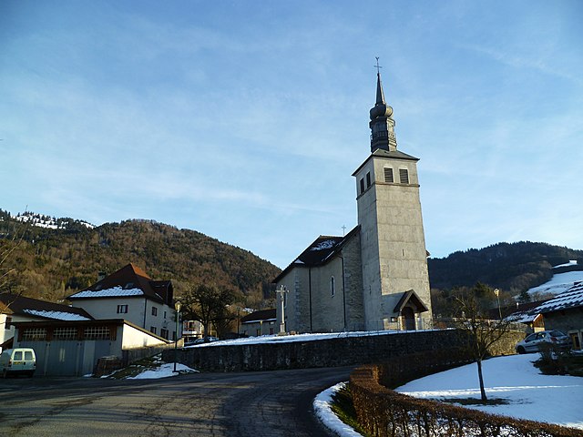
Saint-André-de-Boëge
- commune in Haute-Savoie, France
Hiking in Saint-André-de-Boëge
Saint-André-de-Boëge is a charming commune located in the Haute-Savoie department in the Auvergne-Rhône-Alpes region of southeastern France. It's nestled within the scenic backdrop of the French Alps, making it an appealing destination for outdoor enthusiasts and hikers....
- Country:
- Postal Code: 74420
- Coordinates: 46° 11' 25" N, 6° 23' 37" E
- GPS tracks (wikiloc): [Link]
- Area: 12.6 sq km
- Population: 549

Saint-Jeoire
- commune in Haute-Savoie, France
Hiking in Saint-Jeoire
Saint-Jeoire is a charming village located in the Rhône-Alpes region of France, nestled in the heart of the French Alps. It offers a variety of hiking opportunities, suitable for different skill levels and preferences. Here are some key points to consider about hiking in and around Saint-Jeoire:...
- Country:
- Postal Code: 74490
- Coordinates: 46° 8' 18" N, 6° 27' 34" E
- GPS tracks (wikiloc): [Link]
- Area: 22.75 sq km
- Population: 3252
- Web site: [Link]


Onnion
- commune in Haute-Savoie, France
Hiking in Onnion
Onnion is a picturesque commune located in the Auvergne-Rhône-Alpes region of France, near the French Alps. It's well-known for its beautiful landscapes, traditional alpine architecture, and a range of outdoor activities, particularly hiking. Here are some key points to consider for hiking in Onnion:...
- Country:
- Postal Code: 74490
- Coordinates: 46° 10' 17" N, 6° 28' 44" E
- GPS tracks (wikiloc): [Link]
- Area: 18.97 sq km
- Population: 1260
- Web site: [Link]


Viuz-en-Sallaz
- commune in Haute-Savoie, France
Hiking in Viuz-en-Sallaz
Viuz-en-Sallaz, located in the Haute-Savoie region of France, is an ideal destination for hiking enthusiasts. Nestled in the foothills of the Alps, it offers a mix of scenic landscapes, including lush forests, rolling hills, and panoramic mountain views....
- Country:
- Postal Code: 74250
- Coordinates: 46° 8' 51" N, 6° 24' 37" E
- GPS tracks (wikiloc): [Link]
- Area: 20.99 sq km
- Population: 4206