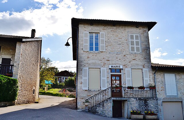
Bohas-Meyriat-Rignat (Bohas-Meyriat-Rignat)
- commune in Ain, France
 Hiking in Bohas-Meyriat-Rignat
Bohas-Meyriat-Rignat is a scenic area located in France, particularly suitable for hikers looking for a mix of natural beauty and tranquility. Nestled in the Jura region, this area features diverse landscapes including rolling hills, forests, and picturesque countryside.
Hiking Trails:
- Variety of Trails: Bohas-Meyriat-Rignat offers several hiking trails, ranging from easy walks suitable for families to more challenging hikes for experienced hikers.
- Marked Paths: Many of the trails are well-marked, making navigation easier. Pay attention to the signage to ensure you stay on the correct path.
- Scenic Views: The trails often provide stunning views of the surrounding Jura mountains and valleys, especially from higher elevations.
Flora and Fauna:
The region is rich in biodiversity, with many opportunities to spot various plant species and wildlife. Keep an eye out for local birds, deer, and other fauna that inhabit the area.
Best Times to Visit:
- Spring and Fall: These seasons offer pleasant temperatures and beautiful scenery, with spring showcasing wildflowers and fall providing vibrant foliage.
- Summer: While summer can be warm, it's also a popular time for hiking. Be sure to start early to avoid the heat and carry enough water.
Safety Tips:
- Stay Hydrated: Always carry enough water, especially during warmer months.
- Dress Appropriately: Wear suitable hiking shoes and clothing based on the season.
- Check Weather Conditions: Before heading out, check the local weather forecast. Sudden weather changes can occur in the mountains.
Additional Activities:
- Guided Tours: Consider joining guided hikes to learn more about the region's natural history and ecology.
- Photography: Bring your camera; the landscapes provide fantastic opportunities for photography, especially in the early morning or late afternoon light.
Local Amenities:
- Accommodation: If you plan to hike over multiple days, check for nearby accommodations or campsites.
- Local Cuisine: Take time to enjoy local cuisine, which may include regional specialties that reflect the culture of the Jura area.
Overall, Bohas-Meyriat-Rignat is a wonderful destination to explore on foot, offering a unique blend of natural beauty and cultural experiences. Happy hiking!
- Country:

- Postal Code: 01250
- Coordinates: 46° 8' 13" N, 5° 23' 28" E


- GPS tracks (wikiloc): [Link]
- Area: 23.51 sq km
- Population: 878
- Web site: https://bohas-meyriat-rignat.fr
- Wikipedia en: wiki(en)
- Wikipedia: wiki(fr)
- Wikidata storage: Wikidata: Q208432
- Wikipedia Commons Category: [Link]
- Wikipedia Commons Maps Category: [Link]
- Freebase ID: [/m/07tt7m]
- Freebase ID: [/m/07tt7m]
- Freebase ID: [/m/07tt7m]
- GeoNames ID: Alt: [6618063]
- GeoNames ID: Alt: [6618063]
- GeoNames ID: Alt: [6618063]
- SIREN number: [210102455]
- SIREN number: [210102455]
- SIREN number: [210102455]
- BnF ID: [121505737]
- BnF ID: [121505737]
- BnF ID: [121505737]
- VIAF ID: Alt: [97144648405902685676]
- VIAF ID: Alt: [97144648405902685676]
- VIAF ID: Alt: [97144648405902685676]
- INSEE municipality code: 01245
- INSEE municipality code: 01245
- INSEE municipality code: 01245
Shares border with regions:

Journans
- commune in Ain, France
Hiking in Journans
Journans, a quaint village located in the Jura department of France, is not widely known as a hiking destination, but it offers access to some beautiful natural landscapes characteristic of the Jura region. The Jura mountains provide a stunning backdrop for hikers, with rolling hills, dense forests, cascading streams, and breathtaking viewpoints....
- Country:
- Postal Code: 01250
- Coordinates: 46° 8' 41" N, 5° 19' 57" E
- GPS tracks (wikiloc): [Link]
- Area: 2.43 sq km
- Population: 355
- Web site: [Link]

Poncin
- commune in Ain, France
Hiking in Poncin
Poncin, a charming village located in the Ain department of France, offers a variety of hiking opportunities for outdoor enthusiasts. The region is characterized by its stunning landscapes, rolling hills, and lush greenery, making it an excellent destination for both casual walkers and seasoned hikers....
- Country:
- Postal Code: 01450
- Coordinates: 46° 5' 6" N, 5° 24' 24" E
- GPS tracks (wikiloc): [Link]
- Area: 19.77 sq km
- Population: 1688
- Web site: [Link]

Revonnas
- commune in Ain, France
Hiking in Revonnas
Revonnas, located in the Auvergne-Rhône-Alpes region of France, offers beautiful hiking opportunities for outdoor enthusiasts. It’s known for its picturesque landscapes, diverse flora and fauna, and proximity to the Bugey mountains....
- Country:
- Postal Code: 01250
- Coordinates: 46° 9' 44" N, 5° 19' 49" E
- GPS tracks (wikiloc): [Link]
- Area: 7.75 sq km
- Population: 938
- Web site: [Link]
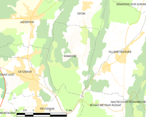
Ramasse
- commune in Ain, France
Hiking in Ramasse
Ramasse is located in the Auvergne region of France, in the department of Puy-de-Dôme. This area offers beautiful landscapes and a variety of hiking trails that cater to different skill levels. The surrounding volcanic terrain, rolling hills, and lush greenery make it an appealing destination for outdoor enthusiasts....
- Country:
- Postal Code: 01250
- Coordinates: 46° 11' 42" N, 5° 21' 19" E
- GPS tracks (wikiloc): [Link]
- Area: 9.86 sq km
- Population: 312
- Web site: [Link]

Hautecourt-Romanèche
- commune in Ain, France
Hiking in Hautecourt-Romanèche
Hautecourt-Romanèche is a charming commune located in the Ain department of the Auvergne-Rhône-Alpes region in southeastern France. This area offers picturesque landscapes with rolling hills, forests, and the beautiful Bugey mountain range, making it an appealing destination for hikers....
- Country:
- Postal Code: 01250
- Coordinates: 46° 9' 35" N, 5° 25' 3" E
- GPS tracks (wikiloc): [Link]
- Area: 21.6 sq km
- Population: 792
- Web site: [Link]

Villereversure
- commune in Ain, France
Hiking in Villereversure
Villereversure is a small commune in the Jura department of France, located in a picturesque area characterized by rolling hills, forests, and panoramic views of the surrounding landscapes. Hiking in this region offers a great escape into nature, with options ranging from easy walks to more challenging trails....
- Country:
- Postal Code: 01250
- Coordinates: 46° 11' 31" N, 5° 23' 46" E
- GPS tracks (wikiloc): [Link]
- Area: 17.45 sq km
- Population: 1262
- Web site: [Link]

Neuville-sur-Ain
- commune in Ain, France
Hiking in Neuville-sur-Ain
Neuville-sur-Ain, located in the Ain department of France, offers a variety of hiking opportunities that cater to different skill levels and preferences. The area is characterized by its beautiful natural landscapes, including hills, rivers, and forests, making it an attractive destination for outdoor enthusiasts....
- Country:
- Postal Code: 01160
- Coordinates: 46° 4' 57" N, 5° 22' 20" E
- GPS tracks (wikiloc): [Link]
- Area: 19.79 sq km
- Population: 1693
- Web site: [Link]

Saint-Martin-du-Mont
- commune in Ain, France
Hiking in Saint-Martin-du-Mont
Saint-Martin-du-Mont is a charming commune situated in the Ain department of the Auvergne-Rhône-Alpes region in southeastern France. The area offers several hiking opportunities that allow you to experience the stunning natural beauty and diverse landscapes of the region....
- Country:
- Postal Code: 01160
- Coordinates: 46° 6' 6" N, 5° 19' 42" E
- GPS tracks (wikiloc): [Link]
- Area: 28.09 sq km
- Population: 1784
- Web site: [Link]