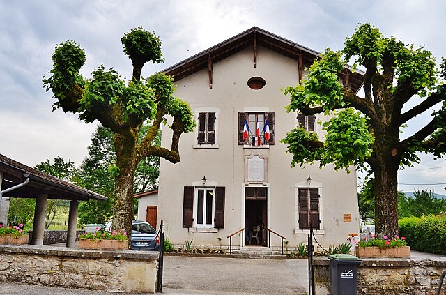
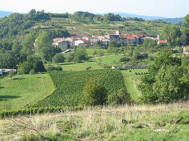
Poncin (Poncin)
- commune in Ain, France
Poncin, a charming village located in the Ain department of France, offers a variety of hiking opportunities for outdoor enthusiasts. The region is characterized by its stunning landscapes, rolling hills, and lush greenery, making it an excellent destination for both casual walkers and seasoned hikers.
Hiking Trails:
-
Local Circuits: There are several marked trails around Poncin that cater to different skill levels. These circuits often lead through beautiful forests, across meadows, and along streams, providing a great way to experience the local flora and fauna.
-
The Ain Valley: A longer trek can take you into the nearby Ain Valley, where you can enjoy breathtaking views and the serenity of nature. Trails in this area may lead to scenic viewpoints and historical sites.
-
Monts du Lyonnais: A bit farther afield, the Monts du Lyonnais offers more challenging hikes with higher elevation gains and the chance to witness stunning panoramas of the surrounding landscape.
Best Times to Hike:
- Spring (April to June): Enjoy blooming wildflowers and mild temperatures, making it perfect for hiking.
- Fall (September to October): Witness the vibrant fall colors and enjoy cooler weather that's ideal for longer treks.
Tips for Hiking in Poncin:
- Equipment: Wear appropriate hiking shoes and bring along plenty of water, snacks, and a map or GPS device.
- Weather: Check the weather forecast before heading out, as conditions can change rapidly in mountainous areas.
- Respect Nature: Always stick to marked trails to minimize your impact on the environment.
Additional Activities:
In addition to hiking, Poncin is near other attractions such as cycling routes, fishing spots, and cultural sites, including churches and historical buildings.
Overall, hiking in Poncin provides an excellent opportunity to explore the natural beauty of the region while enjoying physical activity in a tranquil setting. Whether you're looking for a leisurely walk or a strenuous hike, you're sure to find something that suits your preferences.
- Country:

- Postal Code: 01450
- Coordinates: 46° 5' 6" N, 5° 24' 24" E


- GPS tracks (wikiloc): [Link]
- Area: 19.77 sq km
- Population: 1688
- Web site: http://www.poncin.fr
- Wikipedia en: wiki(en)
- Wikipedia: wiki(fr)
- Wikidata storage: Wikidata: Q665272
- Wikipedia Commons Category: [Link]
- Wikipedia Commons Maps Category: [Link]
- Freebase ID: [/m/081m_1]
- Freebase ID: [/m/081m_1]
- GeoNames ID: Alt: [6424628]
- GeoNames ID: Alt: [6424628]
- SIREN number: [210103032]
- SIREN number: [210103032]
- PACTOLS thesaurus ID: [pcrtdm5rj7f2MG]
- PACTOLS thesaurus ID: [pcrtdm5rj7f2MG]
- INSEE municipality code: 01303
- INSEE municipality code: 01303
Shares border with regions:

Bohas-Meyriat-Rignat
- commune in Ain, France
 Hiking in Bohas-Meyriat-Rignat
Bohas-Meyriat-Rignat is a scenic area located in France, particularly suitable for hikers looking for a mix of natural beauty and tranquility. Nestled in the Jura region, this area features diverse landscapes including rolling hills, forests, and picturesque countryside....
- Country:

- Postal Code: 01250
- Coordinates: 46° 8' 13" N, 5° 23' 28" E


- GPS tracks (wikiloc): [Link]
- Area: 23.51 sq km
- Population: 878
- Web site: [Link]

Cerdon
- commune in Ain, France
Cerdon is a picturesque village located in the Ain department of the Auvergne-Rhône-Alpes region of France. It's known for its stunning landscapes, rich history, and vibrant nature, making it an excellent destination for hiking enthusiasts....
- Country:

- Postal Code: 01450
- Coordinates: 46° 4' 50" N, 5° 27' 57" E


- GPS tracks (wikiloc): [Link]
- Area: 12.3 sq km
- Population: 779

Saint-Alban
- commune in Ain, France
Saint-Alban, located in the Ain department in the Auvergne-Rhône-Alpes region of France, offers beautiful natural landscapes that are perfect for hiking enthusiasts. The area provides a variety of trails suitable for different skill levels, from easy walks to more challenging hikes....
- Country:

- Postal Code: 01450
- Coordinates: 46° 5' 44" N, 5° 27' 12" E


- GPS tracks (wikiloc): [Link]
- Area: 8.08 sq km
- Population: 175

Hautecourt-Romanèche
- commune in Ain, France
 Hiking in Hautecourt-Romanèche
Hautecourt-Romanèche is a charming commune located in the Ain department of the Auvergne-Rhône-Alpes region in southeastern France. This area offers picturesque landscapes with rolling hills, forests, and the beautiful Bugey mountain range, making it an appealing destination for hikers....
- Country:

- Postal Code: 01250
- Coordinates: 46° 9' 35" N, 5° 25' 3" E


- GPS tracks (wikiloc): [Link]
- Area: 21.6 sq km
- Population: 792
- Web site: [Link]

Challes-la-Montagne
- commune in Ain, France
Challes-la-Montagne, located in the Auvergne region of France, is known for its beautiful natural landscapes that offer great hiking opportunities. Here are some aspects you might consider if you plan to hike in that area:...
- Country:

- Postal Code: 01450
- Coordinates: 46° 7' 30" N, 5° 27' 52" E


- GPS tracks (wikiloc): [Link]
- Area: 7.65 sq km
- Population: 189

Mérignat
- commune in Ain, France
Mérignat is a charming village located in the Auvergne region of France, known for its picturesque landscapes and natural beauty, making it an excellent destination for hiking enthusiasts. Here are some highlights and tips for hiking in the Mérignat area:...
- Country:

- Postal Code: 01450
- Coordinates: 46° 4' 10" N, 5° 26' 12" E


- GPS tracks (wikiloc): [Link]
- Area: 3.17 sq km
- Population: 121

Serrières-sur-Ain
- commune in Ain, France
Serrières-sur-Ain is a charming village located in the Ain department of the Auvergne-Rhône-Alpes region in eastern France. The area is known for its picturesque landscapes, including rolling hills, forests, and the flow of the Ain River, making it an excellent spot for hiking enthusiasts....
- Country:

- Postal Code: 01450
- Coordinates: 46° 9' 10" N, 5° 27' 4" E


- GPS tracks (wikiloc): [Link]
- Area: 8.18 sq km
- Population: 128

Neuville-sur-Ain
- commune in Ain, France
Neuville-sur-Ain, located in the Ain department of France, offers a variety of hiking opportunities that cater to different skill levels and preferences. The area is characterized by its beautiful natural landscapes, including hills, rivers, and forests, making it an attractive destination for outdoor enthusiasts....
- Country:

- Postal Code: 01160
- Coordinates: 46° 4' 57" N, 5° 22' 20" E


- GPS tracks (wikiloc): [Link]
- Area: 19.79 sq km
- Population: 1693
- Web site: [Link]

Jujurieux
- commune in Ain, France
Jujurieux is a charming commune located in the Ain department of the Auvergne-Rhône-Alpes region in eastern France. It offers various hiking opportunities that take advantage of its scenic landscapes, rolling hills, and picturesque countryside. Here are some highlights for hiking in and around Jujurieux:...
- Country:

- Postal Code: 01640
- Coordinates: 46° 2' 24" N, 5° 24' 32" E


- GPS tracks (wikiloc): [Link]
- Area: 15.39 sq km
- Population: 2191
- Web site: [Link]