Boisset (Boisset)

- commune in Haute-Loire, France
- Country:

- Postal Code: 43500
- Coordinates: 45° 19' 26" N, 3° 58' 58" E


- GPS tracks (wikiloc): [Link]
- Area: 14.04 sq km
- Population: 321
- Wikipedia en: wiki(en)
- Wikipedia: wiki(fr)
- Wikidata storage: Wikidata: Q940666
- Wikipedia Commons Category: [Link]
- Freebase ID: [/m/03ntj4j]
- GeoNames ID: Alt: [6614873]
- SIREN number: [214300345]
- BnF ID: [15259939x]
- INSEE municipality code: 43034
Shares border with regions:


Saint-André-de-Chalencon
- commune in Haute-Loire, France
- Country:
- Postal Code: 43130
- Coordinates: 45° 16' 22" N, 3° 58' 11" E
- GPS tracks (wikiloc): [Link]
- Area: 17.2 sq km
- Population: 347


Merle-Leignec
- commune in Loire, France
- Country:
- Postal Code: 42380
- Coordinates: 45° 22' 29" N, 4° 1' 3" E
- GPS tracks (wikiloc): [Link]
- Area: 16.17 sq km
- Population: 319


Valprivas
- commune in Haute-Loire, France
- Country:
- Postal Code: 43210
- Coordinates: 45° 18' 41" N, 4° 2' 38" E
- GPS tracks (wikiloc): [Link]
- Area: 23.66 sq km
- Population: 483

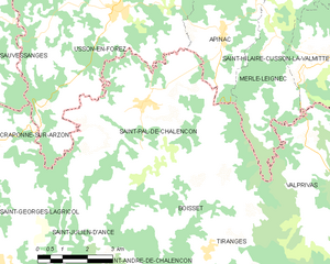
Saint-Pal-de-Chalencon
- commune in Haute-Loire, France
- Country:
- Postal Code: 43500
- Coordinates: 45° 21' 24" N, 3° 57' 25" E
- GPS tracks (wikiloc): [Link]
- AboveSeaLevel: 878 м m
- Area: 28.95 sq km
- Population: 1018
- Web site: [Link]

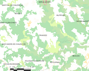
Tiranges
- commune in Haute-Loire, France
- Country:
- Postal Code: 43130
- Coordinates: 45° 18' 15" N, 3° 59' 18" E
- GPS tracks (wikiloc): [Link]
- Area: 26.83 sq km
- Population: 474

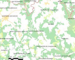
Saint-Julien-d'Ance
- commune in Haute-Loire, France
- Country:
- Postal Code: 43500
- Coordinates: 45° 18' 14" N, 3° 54' 46" E
- GPS tracks (wikiloc): [Link]
- Area: 17.82 sq km
- Population: 247