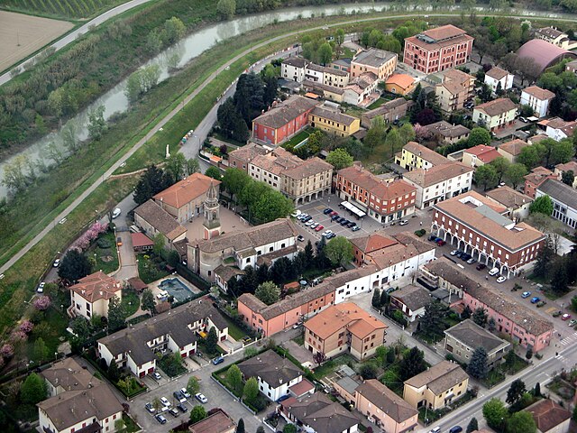
Bomporto (Bomporto)
.svg)
- Italian comune
 Hiking in Bomporto
Bomporto, located in the Emilia-Romagna region of Italy, is a charming area with picturesque landscapes, making it a great destination for hiking enthusiasts. While Bomporto itself may not have extensive hiking trails, there are several options in the surrounding regions that offer beautiful scenery and outdoor experiences.
Hiking Opportunities Near Bomporto:
-
Parco Regionale dell'Appennino Tosco-Emiliano:
- This regional park is a bit further away, but it offers a variety of trails amidst stunning natural landscapes, including mountains, valleys, and forests. The area is known for its biodiversity and is great for both beginner and experienced hikers.
-
Modena Countryside:
- The countryside around Modena, which is not far from Bomporto, features rolling hills, vineyards, and historical sites. There are many walking paths that allow you to explore the local flora and fauna while enjoying views of the vineyards and olive groves.
-
Secchia River Park:
- Located nearby, this park features trails along the Secchia River. It's an excellent spot for hiking, biking, and enjoying nature. You can find scenic spots for picnics along the riverbanks and observe local wildlife.
-
Monte Cimino and other nearby hills:
- If you're looking for more challenging hikes, consider venturing into the hills around the area. Several trails lead to panoramic views and are suitable for various skill levels.
Tips for Hiking in Bomporto:
- Check Local Resources: Before heading out, check local visitor centers or online resources for trail maps, conditions, and any safety advisories.
- Weather Awareness: The weather can change quickly, especially in hilly or mountainous areas. Dress accordingly and take necessary gear.
- Stay Hydrated: Always carry enough water and snacks, especially on longer hikes.
- Respect Nature: Follow Leave No Trace principles, stay on marked trails, and respect wildlife.
Conclusion:
While Bomporto may not be a well-known hiking destination, its proximity to beautiful landscapes and parks offers a variety of hiking opportunities. Whether you're looking for a leisurely walk or a more strenuous hike, the surrounding areas are sure to provide a rewarding experience immersed in nature.
- Country:

- Postal Code: 41030
- Local Dialing Code: 059
- Licence Plate Code: MO
- Coordinates: 44° 44' 0" N, 11° 2' 0" E


- GPS tracks (wikiloc): [Link]
- AboveSeaLevel: 20 м m
- Area: 38.87 sq km
- Population: 10170
- Web site: http://www.comune.bomporto.mo.it/
- Wikipedia en: wiki(en)
- Wikipedia: wiki(it)
- Wikidata storage: Wikidata: Q100038
- Wikipedia Commons Category: [Link]
- Freebase ID: [/m/0gkg12]
- GeoNames ID: Alt: [6538448]
- VIAF ID: Alt: [140918296]
- OSM relation ID: [43498]
- UN/LOCODE: [ITBOM]
- ISTAT ID: 036002
- Italian cadastre code: A959
Shares border with regions:
Bastiglia
- Italian comune
Hiking in Bastiglia
Bastiglia, a lovely municipality in the Emilia-Romagna region of Italy, may not be as well-known as some of the surrounding areas for hiking, but it offers beautiful scenery and opportunities for exploration, particularly for those interested in a mix of urban and rural experiences....
- Country:
- Postal Code: 41030
- Local Dialing Code: 059
- Licence Plate Code: MO
- Coordinates: 44° 43' 37" N, 10° 59' 55" E
- GPS tracks (wikiloc): [Link]
- AboveSeaLevel: 27 м m
- Area: 10.47 sq km
- Population: 4234
- Web site: [Link]

Camposanto
- Italian comune
Hiking in Camposanto
Camposanto, often referred to as Camposanto Monumentale, is not primarily known as a hiking destination but rather as a cemetery located in Pisa, Italy, renowned for its sculpture and art. However, if you are looking for hiking opportunities in the broader Tuscan region, here are some suggestions:...
- Country:
- Postal Code: 41031
- Local Dialing Code: 0535
- Licence Plate Code: MO
- Coordinates: 44° 47' 0" N, 11° 8' 0" E
- GPS tracks (wikiloc): [Link]
- AboveSeaLevel: 21 м m
- Area: 22.71 sq km
- Population: 3049
- Web site: [Link]


Medolla
- Italian comune
Hiking in Medolla
Medolla, located in the Emilia-Romagna region of Italy, is a small town known for its agricultural landscape and proximity to the Po River. While it's not primarily known as a hiking destination, there are opportunities for outdoor activities and exploration of the surrounding countryside....
- Country:
- Postal Code: 41036
- Local Dialing Code: 0535
- Licence Plate Code: MO
- Coordinates: 44° 50' 55" N, 11° 4' 15" E
- GPS tracks (wikiloc): [Link]
- AboveSeaLevel: 22 м m
- Area: 27 sq km
- Population: 6253
- Web site: [Link]


Nonantola
- Italian comune
Hiking in Nonantola
Nonantola, located in the Emilia-Romagna region of Italy, is a charming town that offers a variety of hiking opportunities in the surrounding areas. While Nonantola itself is not known for dramatic mountain trails, the region offers scenic walks through countryside landscapes, lush vineyards, and historical sites....
- Country:
- Postal Code: 41015
- Local Dialing Code: 059
- Licence Plate Code: MO
- Coordinates: 44° 40' 40" N, 11° 2' 35" E
- GPS tracks (wikiloc): [Link]
- AboveSeaLevel: 20 м m
- Area: 55.32 sq km
- Population: 15957
- Web site: [Link]
Ravarino
- Italian comune
Hiking in Ravarino
Ravarino is a small town located in the Emilia-Romagna region of Italy, known for its scenic countryside and proximity to larger cities like Modena and Bologna. While Ravarino itself might not be famous for high-profile hiking trails, the surrounding landscapes offer opportunities for nature lovers and hikers looking to explore the beautiful Italian countryside....
- Country:
- Postal Code: 41017
- Local Dialing Code: 059
- Licence Plate Code: MO
- Coordinates: 44° 43' 0" N, 11° 6' 0" E
- GPS tracks (wikiloc): [Link]
- AboveSeaLevel: 23 м m
- Area: 28.53 sq km
- Population: 6132
- Web site: [Link]
San Prospero
- Italian comune
Hiking in San Prospero
San Prospero isn't as commonly recognized as a major hiking destination compared to other regions, so information may vary depending on the specific location and features you're interested in. However, if you’re referring to San Prospero as found in Italian regions or any lesser-known areas, there may be local trails, countryside walks, and unique landscapes to explore....
- Country:
- Postal Code: 41030
- Local Dialing Code: 059
- Licence Plate Code: MO
- Coordinates: 44° 47' 23" N, 11° 1' 20" E
- GPS tracks (wikiloc): [Link]
- AboveSeaLevel: 22 м m
- Area: 34.56 sq km
- Population: 5933
- Web site: [Link]


Soliera
- Italian comune
Hiking in Soliera
Soliera, located in the Emilia-Romagna region of Italy, is a charming town known for its picturesque landscapes and proximity to the larger city of Modena. While Soliera itself may not be a primary hiking destination, it can serve as a great starting point for exploring nearby natural attractions and trails....
- Country:
- Postal Code: 41019
- Local Dialing Code: 059
- Licence Plate Code: MO
- Coordinates: 44° 44' 17" N, 10° 55' 28" E
- GPS tracks (wikiloc): [Link]
- AboveSeaLevel: 28 м m
- Area: 50.93 sq km
- Population: 15296
- Web site: [Link]
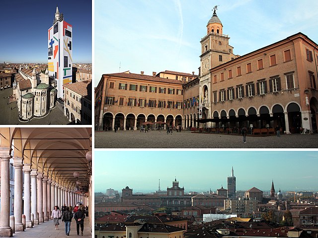

Modena
- Italian city and comune
Hiking in Modena
Modena, located in the Emilia-Romagna region of Italy, is renowned for its rich cultural heritage, delicious cuisine, and beautiful landscapes, making it a great destination for hiking enthusiasts. While Modena itself is a city, its surrounding areas offer fantastic hiking opportunities, particularly in the Apennine Mountains, which are just a short drive away....
- Country:
- Postal Code: 41121–41126
- Local Dialing Code: 059
- Licence Plate Code: MO
- Coordinates: 44° 38' 45" N, 10° 55' 33" E
- GPS tracks (wikiloc): [Link]
- AboveSeaLevel: 34 м m
- Area: 183.19 sq km
- Population: 184727
- Web site: [Link]