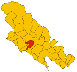
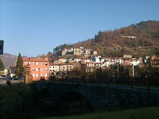
Borghetto di Vara (Borghetto di Vara)
.svg)
- Italian comune
 Hiking in Borghetto di Vara
Borghetto di Vara is a picturesque village located in the Liguria region of Italy, nestled in the foothills of the Apennines, near the Cinque Terre. It offers stunning landscapes, rich history, and a variety of hiking opportunities for outdoor enthusiasts.
Hiking Trails:
-
Val di Vara: This area is known for its extensive network of trails that wind through lush valleys and past charming villages. The trails offer varying levels of difficulty, accommodating both beginners and experienced hikers.
-
Sentiero del Beigua: This trail leads from Borghetto di Vara towards the Beigua Regional Park, featuring breathtaking views of the surrounding mountains and valleys. It's a great way to experience the natural beauty of the region.
-
Cinque Terre National Park: While it’s a bit of a stretch from Borghetto di Vara, many hikers use it as a base to explore the trails of the Cinque Terre National Park. The well-marked paths along the coastline provide stunning sea views and connect the charming villages of the Cinque Terre.
-
Local Interpretations: Some trails in the area also offer a chance to learn about the local flora and fauna, as well as the historical significance of the region. Guided hikes are available, providing deeper insights into the landscape and culture.
Tips for Hiking in Borghetto di Vara:
- Best Time to Go: The ideal time for hiking in this region is spring and autumn when the weather is mild and the scenery is at its most vibrant.
- Preparation: Carry sufficient water, wear sturdy hiking boots, and bring a map or GPS device, as some trails may not be well-signposted.
- Local Cuisine: After a long hike, explore Borghetto di Vara’s local eateries to enjoy traditional Ligurian cuisine, including pesto, focaccia, and fresh seafood.
Safety:
- Always check the weather before your hike and inform someone of your plan.
- Hike with a buddy if possible and carry a basic first-aid kit.
Borghetto di Vara is an excellent destination for those looking to explore both nature and local culture amidst the beautiful Ligurian landscape. Enjoy your hiking adventure!
- Country:

- Postal Code: 19020
- Local Dialing Code: 0187
- Licence Plate Code: SP
- Coordinates: 44° 13' 26" N, 9° 43' 17" E


- GPS tracks (wikiloc): [Link]
- AboveSeaLevel: 104 м m
- Area: 27.34 sq km
- Population: 920
- Web site: http://www.borghettosantospirito.gov.it
- Wikipedia en: wiki(en)
- Wikipedia: wiki(it)
- Wikidata storage: Wikidata: Q270050
- Wikipedia Commons Category: [Link]
- Freebase ID: [/m/0ghx5h]
- GeoNames ID: Alt: [6537068]
- VIAF ID: Alt: [240913835]
- OSM relation ID: [42942]
- WOEID: [711165]
- ISTAT ID: 011006
- Italian cadastre code: A992
Shares border with regions:


Carrodano
- Italian comune
Hiking in Carrodano
Carrodano is a charming municipality located in the Liguria region of Italy, nestled in the picturesque landscape of the Italian Riviera. It offers a variety of hiking opportunities, showcasing lush forests, stunning views, and the rich biodiversity of the area. Here are some key points to consider if you want to hike in Carrodano:...
- Country:
- Postal Code: 19020
- Local Dialing Code: 0187
- Licence Plate Code: SP
- Coordinates: 44° 14' 31" N, 9° 39' 22" E
- GPS tracks (wikiloc): [Link]
- AboveSeaLevel: 215 м m
- Area: 21.86 sq km
- Population: 488
- Web site: [Link]


Levanto, Liguria
- Italian comune
Hiking in Levanto, Liguria
Levanto, located on the beautiful Italian Riviera in Liguria, is a fantastic destination for hiking enthusiasts. Nestled between the Mediterranean Sea and the rugged hills, Levanto serves as a gateway to both the Cinque Terre National Park and the surrounding coastal trails. Here are some highlights about hiking in and around Levanto:...
- Country:
- Postal Code: 19015
- Local Dialing Code: 0187
- Licence Plate Code: SP
- Coordinates: 44° 10' 11" N, 9° 36' 44" E
- GPS tracks (wikiloc): [Link]
- AboveSeaLevel: 3 м m
- Area: 36.81 sq km
- Population: 5403
- Web site: [Link]


Beverino
- Italian comune
Hiking in Beverino
Beverino is a charming village located in the Liguria region of Italy, close to the more famous Cinque Terre. This area offers stunning landscapes, lush greenery, and fantastic views, making it an excellent destination for hiking enthusiasts....
- Country:
- Postal Code: 19020
- Local Dialing Code: 0187
- Licence Plate Code: SP
- Coordinates: 44° 11' 45" N, 9° 46' 7" E
- GPS tracks (wikiloc): [Link]
- AboveSeaLevel: 73 м m
- Area: 34.95 sq km
- Population: 2396
- Web site: [Link]


Brugnato
- Italian comune
Hiking in Brugnato
Brugnato, located in the Liguria region of Italy, offers a charming setting for hiking enthusiasts. Nestled in a valley, this small historical village is surrounded by the lush landscape of the Ligurian Apennines. Here are some highlights about hiking in Brugnato:...
- Country:
- Postal Code: 19020
- Local Dialing Code: 0187
- Licence Plate Code: SP
- Coordinates: 44° 14' 12" N, 9° 43' 31" E
- GPS tracks (wikiloc): [Link]
- AboveSeaLevel: 115 м m
- Area: 11.9 sq km
- Population: 1309
- Web site: [Link]

Pignone
- Italian comune
Hiking in Pignone
Pignone is a charming village located in the Liguria region of Italy, near the famous Cinque Terre National Park. It offers a beautiful setting for hiking enthusiasts, featuring diverse landscapes including hills, vineyards, olive groves, and stunning views of the Mediterranean coast....
- Country:
- Postal Code: 19020
- Local Dialing Code: 0187
- Licence Plate Code: SP
- Coordinates: 44° 10' 44" N, 9° 43' 27" E
- GPS tracks (wikiloc): [Link]
- AboveSeaLevel: 189 м m
- Area: 17.75 sq km
- Population: 567
- Web site: [Link]

Rocchetta di Vara
- Italian comune
Hiking in Rocchetta di Vara
Rocchetta di Vara is a charming village located in the Liguria region of Italy, nestled in the hills of the Val di Vara. This area is known for its picturesque landscapes, lush greenery, and diverse hiking trails that appeal to all levels of hikers....
- Country:
- Postal Code: 19020
- Local Dialing Code: 0187
- Licence Plate Code: SP
- Coordinates: 44° 15' 4" N, 9° 45' 26" E
- GPS tracks (wikiloc): [Link]
- AboveSeaLevel: 220 м m
- Area: 32.66 sq km
- Population: 701
- Web site: [Link]


Sesta Godano
- Italian comune
Hiking in Sesta Godano
Sesta Godano is a charming village located in the heart of the Ligurian region of Italy, surrounded by the beautiful landscapes of the Ligurian Apennines. It offers a variety of hiking opportunities for all levels, making it an excellent destination for outdoor enthusiasts....
- Country:
- Postal Code: 19020
- Local Dialing Code: 0187
- Licence Plate Code: SP
- Coordinates: 44° 17' 37" N, 9° 40' 32" E
- GPS tracks (wikiloc): [Link]
- AboveSeaLevel: 242 м m
- Area: 67.78 sq km
- Population: 1339
- Web site: [Link]