Bosselshausen (Bosselshausen)
- commune in Bas-Rhin, France
- Country:

- Postal Code: 67330
- Coordinates: 48° 48' 18" N, 7° 30' 36" E


- GPS tracks (wikiloc): [Link]
- Area: 3.29 sq km
- Population: 158
- Wikipedia en: wiki(en)
- Wikipedia: wiki(fr)
- Wikidata storage: Wikidata: Q22783
- Wikipedia Commons Category: [Link]
- Freebase ID: [/m/02rwxy_]
- Freebase ID: [/m/02rwxy_]
- GeoNames ID: Alt: [6694105]
- GeoNames ID: Alt: [6694105]
- SIREN number: [216700575]
- SIREN number: [216700575]
- BnF ID: [15271200f]
- BnF ID: [15271200f]
- VIAF ID: Alt: [244727733]
- VIAF ID: Alt: [244727733]
- INSEE municipality code: 67057
- INSEE municipality code: 67057
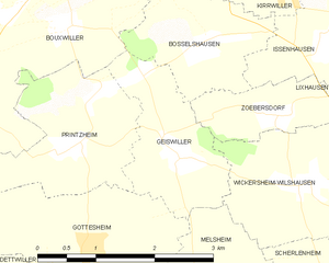
Shares border with regions:


Geiswiller
- former commune in Bas-Rhin, France
- Country:

- Postal Code: 67270
- Coordinates: 48° 47' 17" N, 7° 30' 11" E


- GPS tracks (wikiloc): [Link]
- Area: 3.2 sq km
- Population: 218


Zœbersdorf
- former commune in Bas-Rhin, France
- Country:

- Postal Code: 67270
- Coordinates: 48° 47' 36" N, 7° 31' 27" E


- GPS tracks (wikiloc): [Link]
- AboveSeaLevel: 220 м m
- Area: 1.85 sq km
- Population: 178


Issenhausen
- commune in Bas-Rhin, France
- Country:

- Postal Code: 67330
- Coordinates: 48° 48' 18" N, 7° 32' 13" E


- GPS tracks (wikiloc): [Link]
- Area: 2.1 sq km
- Population: 105


Bouxwiller
- commune in Bas-Rhin, France
- Country:

- Postal Code: 67330
- Coordinates: 48° 49' 31" N, 7° 28' 58" E


- GPS tracks (wikiloc): [Link]
- Area: 25.59 sq km
- Population: 4071
- Web site: [Link]


Kirrwiller
- commune in Bas-Rhin, France
- Country:

- Postal Code: 67330
- Coordinates: 48° 48' 50" N, 7° 31' 49" E


- GPS tracks (wikiloc): [Link]
- Area: 4.89 sq km
- Population: 565
