Bothel (Samtgemeinde Bothel)
- Samtgemeinde in Lower Saxony
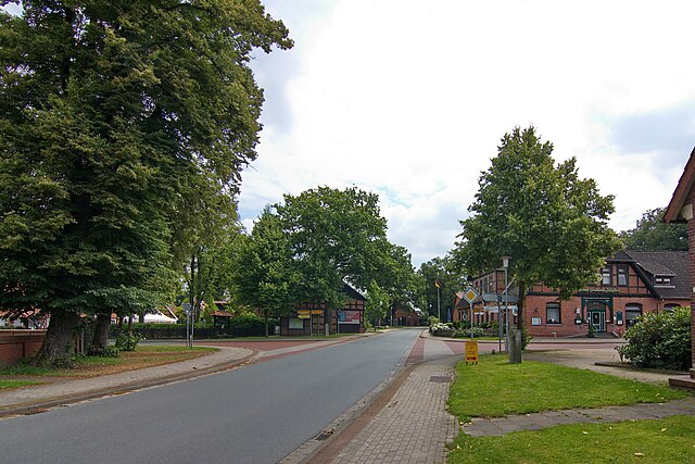
Bothel, located in the Samtgemeinde of Bothel in Lower Saxony, Germany, is a relatively small area that offers a peaceful hiking experience amidst nature. While it may not be as well-known for extensive hiking trails as some larger regions, it can still provide beautiful rural scenery, forests, and serene landscapes for those looking for a quiet escape into nature.
Hiking Highlights in Bothel:
-
Scenic Routes: The area features several scenic walking paths that wind through forests, fields, and along rivers. These trails are typically flat and suitable for hikers of all skill levels.
-
Nature Observation: The region offers opportunities for birdwatching and observing local wildlife. Bring binoculars to enhance your experience.
-
Lakes and Waterways: Depending on the time of year, there are likely to be nearby lakes or small rivers. Hiking along these areas can provide beautiful views and places to rest.
-
Local Flora and Fauna: Take the time to appreciate the local plant life and possibly spot unique species of fauna, particularly in the forests and fields.
-
Historical Sites: You might encounter small historical landmarks or traditional farmhouses along your hiking routes. These can offer insight into the local culture and history.
Tips for Hiking in Bothel:
-
Maps and Trails: Before heading out, it’s advisable to check for local hiking maps or digital trail guides that can assist you in navigating.
-
Weather Preparedness: Always check the weather before your hike, as conditions can change quickly, particularly in forested areas.
-
Safety Gear: Wear appropriate hiking shoes, and consider packing a small first-aid kit, water, and snacks.
-
Respect Nature: Stay on marked paths to protect the local environment and wildlife. Remember to carry out what you bring in.
-
Local Guidance: Don’t hesitate to ask locals about their favorite trails or spots—they often have valuable insights about the best hiking experiences in the area.
Bothel is a great option for those looking to enjoy a peaceful hike while connecting with nature away from the crowds. Enjoy your adventure!
- Country:

- Coordinates: 53° 4' 12" N, 9° 29' 51" E


- GPS tracks (wikiloc): [Link]
- Population: 8157
- Web site: http://www.bothel.de/
- Wikipedia en: wiki(en)
- Wikipedia: wiki(de)
- Wikidata storage: Wikidata: Q489381
- Freebase ID: [/m/027m0pc]
- Freebase ID: [/m/027m0pc]
- Freebase ID: [/m/027m0pc]
- VIAF ID: Alt: [239624984]
- VIAF ID: Alt: [239624984]
- VIAF ID: Alt: [239624984]
- GND ID: Alt: [4389371-5]
- GND ID: Alt: [4389371-5]
- GND ID: Alt: [4389371-5]
- ISNI: Alt: [0000 0004 1789 7280]
- ISNI: Alt: [0000 0004 1789 7280]
- ISNI: Alt: [0000 0004 1789 7280]
- Ringgold ID: [377415]
- Ringgold ID: [377415]
- Ringgold ID: [377415]
- German regional key: 033575401
- German regional key: 033575401
- German regional key: 033575401
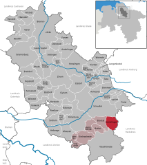
Includes regions:


Kirchwalsede
- municipality of Germany
Kirchwalsede is a small village located in Lower Saxony, Germany, surrounded by beautiful natural landscapes, making it an attractive destination for hiking enthusiasts. While it may not be as widely known as some larger hiking regions, here is what you can expect when hiking in and around Kirchwalsede:...
- Country:

- Postal Code: 27386
- Local Dialing Code: 04269
- Licence Plate Code: ROW
- Coordinates: 53° 1' 0" N, 9° 24' 0" E


- GPS tracks (wikiloc): [Link]
- AboveSeaLevel: 54 м m
- Area: 36.9 sq km
- Population: 1161
- Web site: [Link]
Bothel
- municipality of Germany
Bothel, a small village in Lower Saxony, Germany, is surrounded by beautiful landscapes that offer a variety of hiking opportunities. The region is characterized by its rolling hills, dense forests, and picturesque farmland, making it an excellent destination for outdoor enthusiasts....
- Country:

- Postal Code: 27386
- Local Dialing Code: 04266
- Licence Plate Code: ROW
- Coordinates: 53° 4' 27" N, 9° 30' 16" E


- GPS tracks (wikiloc): [Link]
- AboveSeaLevel: 31 м m
- Area: 16.75 sq km
- Population: 2375
- Web site: [Link]
Hemsbünde
- municipality of Germany
Hemsbünde, located in Lower Saxony, Germany, is not as widely known as some other hiking destinations but offers beautiful landscapes and outdoor opportunities. The area is characterized by rolling hills, woodlands, and serene countryside, making it perfect for nature hikes and leisurely walks....
- Country:

- Postal Code: 27386
- Local Dialing Code: 04266; 04261; 04260
- Licence Plate Code: ROW
- Coordinates: 53° 6' 0" N, 9° 28' 0" E


- GPS tracks (wikiloc): [Link]
- AboveSeaLevel: 28 м m
- Area: 22.33 sq km
- Population: 1147
- Web site: [Link]
Westerwalsede
- municipality of Germany
Westerwalsede is a small town located in Lower Saxony, Germany, and while it may not be as widely recognized as some hiking destinations, it offers an array of beautiful landscapes and nature to explore. Here are some insights into hiking in and around Westerwalsede:...
- Country:

- Postal Code: 27386
- Local Dialing Code: 04269
- Licence Plate Code: ROW
- Coordinates: 53° 2' 0" N, 9° 22' 0" E


- GPS tracks (wikiloc): [Link]
- AboveSeaLevel: 50 м m
- Area: 20.18 sq km
- Population: 720
- Web site: [Link]


Hemslingen
- municipality of Germany
Hemslingen is a charming village located in Lower Saxony, Germany, known for its picturesque landscapes and tranquil environment. While it may not be as popular as some larger hiking destinations, it offers a range of opportunities for those looking to explore the outdoors....
- Country:

- Postal Code: 27386
- Local Dialing Code: 04266
- Licence Plate Code: ROW
- Coordinates: 53° 5' 21" N, 9° 36' 6" E


- GPS tracks (wikiloc): [Link]
- AboveSeaLevel: 42 м m
- Area: 27.46 sq km
- Population: 1415
- Web site: [Link]


Brockel
- municipality of Germany
Brockel is a small town located in Lower Saxony, Germany, surrounded by beautiful natural landscapes that offer great opportunities for hiking and outdoor activities. While the town itself may not be widely known for extensive hiking trails, the surrounding area features various scenic routes and paths that cater to hikers of different skill levels....
- Country:

- Postal Code: 27386
- Local Dialing Code: 04266
- Licence Plate Code: ROW
- Coordinates: 53° 6' 0" N, 9° 31' 0" E


- GPS tracks (wikiloc): [Link]
- AboveSeaLevel: 34 м m
- Area: 25.12 sq km
- Population: 1340
- Web site: [Link]

