Boulc (Boulc)

- commune in Drôme, France
 Hiking in Boulc
Boulc is a charming village located in the Drôme department of the Auvergne-Rhône-Alpes region in southeastern France. It is surrounded by beautiful natural landscapes, making it a great destination for hiking enthusiasts.
Hiking Opportunities:
-
Scenic Trails: The area around Boulc features various hiking trails that offer stunning views of the surrounding mountains, valleys, and nearby rivers. The terrain ranges from gentle slopes to more challenging ascents, catering to hikers of all skill levels.
-
Local Flora and Fauna: While hiking, you can enjoy the local biodiversity, including various plant species, wildflowers, and potential wildlife sightings. Be sure to carry binoculars if you’re interested in birdwatching!
-
Nearby Natural Parks: Boulc is close to the Vercors Regional Natural Park and the Parc naturel régional du Diois. These parks offer numerous marked trails and showcase spectacular limestone cliffs, gorges, and diverse ecosystems.
-
Cultural Insights: Some trails might lead you to historical sites, chapels, or remnants of ancient villages, allowing you to experience both the natural beauty and cultural heritage of the region.
Tips for Hiking in Boulc:
- Trail Maps: Always carry a detailed map or download a hiking app with offline maps to navigate the trails effectively.
- Weather Preparedness: Check the weather forecast before heading out, as conditions can change rapidly in mountainous areas. Dress in layers and bring waterproof gear if necessary.
- Hydration and Snacks: Carry enough water and energy snacks, especially for longer hikes.
- Appropriate Footwear: Wear sturdy hiking boots or shoes for better traction and support on uneven terrain.
- Respect Nature: Leave no trace, stay on marked paths, and respect local wildlife and flora.
Local Resources:
- Tourist Information: Check for local tourist information centers that might provide additional hiking guides or updates on trail conditions.
- Guided Hikes: If you prefer, consider joining guided hikes led by local experts who can provide valuable insights into the region's natural and cultural history.
Enjoy your hiking adventures in Boulc, and be sure to immerse yourself in the beautiful surroundings!
- Country:

- Postal Code: 26410
- Coordinates: 44° 38' 52" N, 5° 34' 1" E


- GPS tracks (wikiloc): [Link]
- Area: 57.35 sq km
- Population: 124
- Wikipedia en: wiki(en)
- Wikipedia: wiki(fr)
- Wikidata storage: Wikidata: Q1094784
- Wikipedia Commons Category: [Link]
- Freebase ID: [/m/03mgkxh]
- GeoNames ID: Alt: [6447894]
- SIREN number: [212600555]
- BnF ID: [15252916k]
- PACTOLS thesaurus ID: [pcrtBwBrfGa0oq]
- INSEE municipality code: 26055
Shares border with regions:

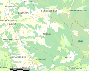
Menglon
- commune in Drôme, France
Hiking in Menglon
Menglon is a picturesque village located in the Drôme department of southeastern France, known for its proximity to the stunning Vercors Regional Natural Park. This area offers a variety of hiking opportunities suitable for different skill levels, making it a great destination for outdoor enthusiasts....
- Country:
- Postal Code: 26410
- Coordinates: 44° 39' 51" N, 5° 27' 44" E
- GPS tracks (wikiloc): [Link]
- Area: 36.47 sq km
- Population: 485

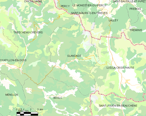
Glandage
- commune in Drôme, France
Hiking in Glandage
It seems like there might be a typo in your request, as "Glandage" does not correspond to a well-known hiking location. If you meant "Glandage" in France, located in the Drôme department, I'd be happy to provide information about hiking in that area....
- Country:
- Postal Code: 26410
- Coordinates: 44° 41' 17" N, 5° 35' 54" E
- GPS tracks (wikiloc): [Link]
- Area: 52.11 sq km
- Population: 115
Miscon
- commune in Drôme, France
Hiking in Miscon
Hiking in Wisconsin offers a diverse range of experiences, from scenic trails in state parks to more rugged terrain in national forests. Here are some highlights:...
- Country:
- Postal Code: 26310
- Coordinates: 44° 37' 43" N, 5° 31' 28" E
- GPS tracks (wikiloc): [Link]
- Area: 12.66 sq km
- Population: 59
Val-Maravel
- commune in Drôme, France
Hiking in Val-Maravel
Val-Maravel is known for its stunning landscapes and diverse ecosystems, making it a fantastic destination for hikers of all skill levels. The area typically features a mix of lush valleys, rugged mountains, and serene lakes, providing a variety of trails that cater to different experiences—from leisurely strolls to challenging climbs....
- Country:
- Postal Code: 26310
- Coordinates: 44° 35' 30" N, 5° 34' 11" E
- GPS tracks (wikiloc): [Link]
- Area: 21.6 sq km
- Population: 56


Treschenu-Creyers
- commune in Drôme, France
Hiking in Treschenu-Creyers
Treschenu-Creyers is a picturesque village located in the heart of the French Alps, near the beautiful Vercors National Park. The stunning natural landscape surrounding the village offers many opportunities for hiking enthusiasts of all skill levels. Here’s a brief overview of what you can expect when hiking in the area:...
- Country:
- Postal Code: 26410
- Coordinates: 44° 44' 15" N, 5° 33' 14" E
- GPS tracks (wikiloc): [Link]
- Area: 82.04 sq km
- Population: 112

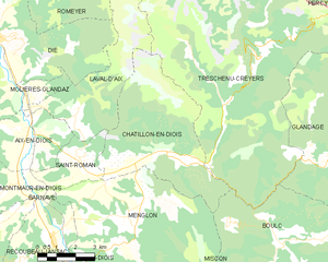
Châtillon-en-Diois
- commune in Drôme, France
Hiking in Châtillon-en-Diois
Châtillon-en-Diois is a picturesque commune located in the Drôme department of France, nestled in the foothills of the Vercors Mountains. It is a great destination for hiking, offering a variety of trails that cater to different skill levels and preferences. Here are some highlights about hiking in and around this beautiful area:...
- Country:
- Postal Code: 26410
- Coordinates: 44° 41' 41" N, 5° 29' 3" E
- GPS tracks (wikiloc): [Link]
- Area: 28.02 sq km
- Population: 555
- Web site: [Link]
Montbrand
- commune in Hautes-Alpes, France
Hiking in Montbrand
Montbrand is a charming area in the French Alps, known for its serene natural landscapes and opportunities for outdoor enthusiasts, particularly hikers. While specific trails and conditions may vary, here are some general insights into hiking in Montbrand:...
- Country:
- Postal Code: 05140
- Coordinates: 44° 35' 23" N, 5° 40' 57" E
- GPS tracks (wikiloc): [Link]
- Area: 25.03 sq km
- Population: 65

Saint-Julien-en-Beauchêne
- commune in Hautes-Alpes, France
Hiking in Saint-Julien-en-Beauchêne
Saint-Julien-en-Beauchêne is a charming commune located in the Hautes-Alpes region of southeastern France. The area is known for its stunning natural landscapes, including mountains, forests, and picturesque valleys, making it an excellent destination for hikers of all levels....
- Country:
- Postal Code: 05140
- Coordinates: 44° 36' 58" N, 5° 42' 35" E
- GPS tracks (wikiloc): [Link]
- Area: 59.43 sq km
- Population: 124
- Web site: [Link]
Lesches-en-Diois
- commune in Drôme, France
Hiking in Lesches-en-Diois
Lesches-en-Diois is a charming village located in the Drôme department of the Auvergne-Rhône-Alpes region in France. This area is known for its stunning natural landscapes, making it a great destination for hiking enthusiasts. Here are some highlights about hiking in this region:...
- Country:
- Postal Code: 26310
- Coordinates: 44° 35' 52" N, 5° 31' 43" E
- GPS tracks (wikiloc): [Link]
- Area: 20.08 sq km
- Population: 47