arrondissement of Die (arrondissement de Die)

- arrondissement of France
 Hiking in arrondissement of Die
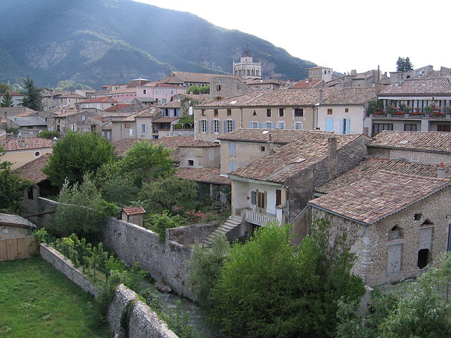
The Arrondissement of Die, located in the Drôme department of southeastern France, offers beautiful and varied landscapes that are perfect for hiking enthusiasts. Nestled in the Rhône-Alpes region, Die is surrounded by the stunning Vercors and Diois mountains, providing a range of trails suitable for different skill levels and experiences.
Key Highlights for Hiking in the Arrondissement of Die:
-
Diois Region: Known for its breathtaking views and diverse geology, the Diois region offers many hiking trails that lead you through picturesque valleys, vineyards, and limestone cliffs.
-
Vercors Regional Natural Park: Just north of Die, this park features dramatic scenery with deep gorges, soaring peaks, and extensive forests. There are numerous well-marked trails suitable for both day hikes and multi-day treks.
-
Mont Aiguille: One of the most iconic peaks in the area, Mont Aiguille presents a challenge for experienced hikers and climbers. The hike to the summit rewards adventurers with stunning panoramic views.
-
Champsaur Valley: This area is perfect for those who enjoy more tranquil hikes, with routes that take you through charming villages, lush meadows, and along the riverbanks.
-
Flora and Fauna: The diverse ecosystems in and around Die are home to wildflowers, rare plants, and a variety of wildlife, making hikes here particularly rewarding for nature enthusiasts.
-
Local Culture: Hiking in the area allows you to connect with the local culture. Many trails lead through historic villages where you can experience regional cuisine and hospitality.
Tips for Hiking in Die:
-
Maps and Guides: Always carry a map or use a hiking app to ensure you stay on the right path. The trails are generally well-marked, but a good map can help you discover lesser-known routes.
-
Weather Preparedness: The weather can change rapidly in the mountains, so be sure to check the forecast and carry appropriate gear, including layers, rain jackets, and plenty of water.
-
Trail Difficulty: Choose hikes that match your fitness level and experience. Trails can vary from easy walks to challenging climbs.
-
Respect Nature: Follow Leave No Trace principles and respect the natural environment, wildlife, and local communities.
Conclusion:
Whether you're looking for a leisurely stroll or an adventurous trek, the Arrondissement of Die has something to offer every hiker. Enjoy the spectacular natural scenery and the rich cultural heritage of this beautiful region in France!
- Country:

- Capital: Die
- Coordinates: 44° 40' 0" N, 5° 15' 0" E


- GPS tracks (wikiloc): [Link]
- Area: 2287 sq km
- Population: 66375
- Wikipedia en: wiki(en)
- Wikipedia: wiki(fr)
- Wikidata storage: Wikidata: Q701097
- Freebase ID: [/m/095hmc]
- GeoNames ID: Alt: [3021434]
- INSEE arrondissement code: [261]
- GNS Unique Feature ID: -1423918
Includes regions:

canton of La Chapelle-en-Vercors
- canton of France (until March 2015)
Hiking in canton of La Chapelle-en-Vercors
Canton de La Chapelle-en-Vercors is a stunning area located in the Vercors Regional Natural Park in the Auvergne-Rhône-Alpes region of France. Known for its rugged limestone cliffs, lush forests, and diverse flora and fauna, it offers numerous hiking opportunities for all skill levels. Here’s an overview of what you can expect when hiking in this beautiful region:...
- Country:
- Capital: La Chapelle-en-Vercors
- Coordinates: 44° 58' 27" N, 5° 25' 18" E
- GPS tracks (wikiloc): [Link]

canton of La Motte-Chalancon
- canton of France (until March 2015)
Hiking in canton of La Motte-Chalancon
Canton de La Motte-Chalancon is a picturesque area located in the Drôme department in southeastern France. It's known for its stunning natural landscapes, rugged terrain, and charming villages, making it a wonderful destination for hiking enthusiasts. Here are some key points about hiking in this region:...
- Country:
- Capital: La Motte-Chalancon
- Coordinates: 44° 32' 8" N, 5° 20' 58" E
- GPS tracks (wikiloc): [Link]

canton of Saillans
- canton of France (until March 2015)
Hiking in canton of Saillans
Canton de Saillans, nestled in the Drôme department of France, is a fantastic destination for hiking enthusiasts. Known for its stunning landscapes, diverse terrain, and charming villages, this area offers a variety of trails suitable for all levels of hikers....

canton of Bourdeaux
- canton of France
Hiking in canton of Bourdeaux
Canton de Bourdeaux is a stunning area located in the Drôme department in the Auvergne-Rhône-Alpes region of France. The region is known for its picturesque landscapes, characterized by rolling hills, forests, and stunning views of the surrounding mountains. Hiking in this area can be a delightful experience, whether you're a beginner or an experienced hiker....

canton of Crest-Nord
- canton of France
Hiking in canton of Crest-Nord
Canton de Crest-Nord, located in the Drôme department of southeastern France, is known for its beautiful landscapes and varied hiking opportunities. The region is characterized by its picturesque valleys, rolling hills, and stunning views of the Vercors and Diois mountains. Here are some key points about hiking in this region:...

canton of Crest-Sud
- canton in Die, Drôme, Rhône-Alpes, France
Hiking in canton of Crest-Sud
Canton de Crest-Sud, located in the Drôme department in the Auvergne-Rhône-Alpes region of southeastern France, offers a variety of hiking opportunities that cater to different skill levels and preferences. The area is characterized by its diverse landscapes, including rolling hills, valleys, and scenic views of the Vercors and Provence....
canton of Die
- canton of France
Hiking in canton of Die
Canton de Die, located in the Drôme department in the Auvergne-Rhône-Alpes region of southeastern France, offers a variety of hiking opportunities for all levels of hikers. This picturesque area is known for its stunning landscapes, characterized by the dramatic limestone cliffs of the Vercors Massif, rolling hills, and beautiful valleys....

canton of Luc-en-Diois
- canton of France
Hiking in canton of Luc-en-Diois
Canton de Luc-en-Diois is a beautiful region located in the Drôme department of southeastern France, within the Auvergne-Rhône-Alpes region. Nestled in the foothills of the Alps, this area features stunning landscapes characterized by rolling hills, limestone cliffs, and lush valleys, making it an excellent destination for hiking enthusiasts....
- Country:
- Capital: Luc-en-Diois
- Coordinates: 44° 35' 26" N, 5° 28' 36" E
- GPS tracks (wikiloc): [Link]

canton of Châtillon-en-Diois
- canton of France (until March 2015)
Hiking in canton of Châtillon-en-Diois
Canton de Châtillon-en-Diois, located in the Drôme department of France, is a picturesque area that offers a variety of hiking opportunities. It is known for its stunning landscapes, including the dramatic cliffs of the Vercors mountains, lush valleys, and charming villages. Here are some highlights for hiking in this region:...
- Country:
- Capital: Châtillon-en-Diois
- Coordinates: 44° 41' 19" N, 5° 32' 16" E
- GPS tracks (wikiloc): [Link]