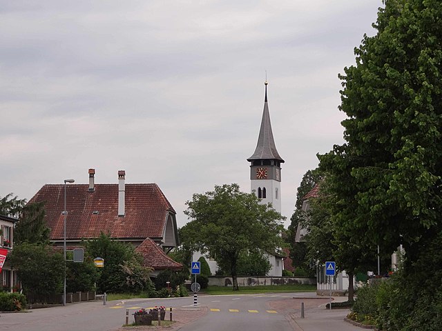
Bremgarten bei Bern (Bremgarten bei Bern)

- municipality in Switzerland
 Hiking in Bremgarten bei Bern
Bremgarten bei Bern is a picturesque area located near the capital of Switzerland. It offers a delightful environment for hiking enthusiasts with its scenic views, lush greenery, and cultural landmarks. Here are some highlights about hiking in this region:
Trails and Routes
-
Diverse Terrain: The area around Bremgarten features a variety of trails, ranging from easy walks suitable for beginners to more challenging hikes for experienced trekkers. The trails often wind through forests, meadows, and along rivers.
-
The Aare River Trail: One popular option is to hike along the Aare River. This path provides stunning views and allows for a refreshing ambiance as you follow the river's banks.
-
Nearby Nature Reserves: Consider exploring nearby nature reserves, like the Gantrisch Nature Park, which offers a range of trails through beautiful alpine meadows and stunning mountain views.
Scenic Highlights
-
Villages and Arboretums: As you hike, you can pass through charming Swiss villages and arboretums filled with various tree species. These areas often provide plenty of photo opportunities.
-
Panoramic Views: Higher elevation trails around Bremgarten can provide sweeping views of the Bernese Alps and the surrounding countryside.
Accessibility
-
Public Transport: Bremgarten is accessible by public transport from Bern, making it convenient to reach the starting points of various trails.
-
Signposted Trails: The hiking trails are generally well-marked, making navigation easy even for those who might not be familiar with the local area.
Safety and Tips
- Weather Check: Always check the weather conditions before heading out, as they can change quickly in the mountains.
- Equipment: Wear appropriate hiking shoes, and consider bringing trekking poles for more challenging trails. A daypack with water and snacks is advisable.
- Leave No Trace: Practice responsible hiking by sticking to designated trails and taking your trash with you.
Conclusion
Hiking in Bremgarten bei Bern offers a harmonious blend of nature, tranquility, and stunning scenery, making it an excellent destination for a day hike or a longer excursion. Whether you're looking for a leisurely stroll or an adventurous trek, there's something for everyone in this beautiful region of Switzerland.
- Country:

- Postal Code: 3047
- Local Dialing Code: 031
- Licence Plate Code: BE
- Coordinates: 46° 58' 31" N, 7° 26' 15" E


- GPS tracks (wikiloc): [Link]
- AboveSeaLevel: 548 м m
- Area: 1.9 sq km
- Population: 4420
- Web site: http://www.bremgarten-be.ch
- Wikipedia en: wiki(en)
- Wikipedia: wiki(de)
- Wikidata storage: Wikidata: Q68185
- Wikipedia Commons Category: [Link]
- Freebase ID: [/m/02_6fs]
- GeoNames ID: Alt: [7285325]
- VIAF ID: Alt: [137550601]
- OSM relation ID: [1682389]
- archINFORM location ID: [1501]
- Library of Congress authority ID: Alt: [no2003063991]
- HDS ID: [211]
- Swiss municipality code: [0353]
Shares border with regions:

Zollikofen
- municipality in Switzerland
Hiking in Zollikofen
Zollikofen is a picturesque municipality located just outside of Bern, Switzerland. It offers an excellent environment for hiking enthusiasts, with trails that provide beautiful views of the surrounding landscape, including the Alps and the Aare River....
- Country:
- Postal Code: 3052
- Local Dialing Code: 031
- Licence Plate Code: BE
- Coordinates: 46° 59' 39" N, 7° 27' 9" E
- GPS tracks (wikiloc): [Link]
- AboveSeaLevel: 562 м m
- Area: 5.4 sq km
- Population: 10314
- Web site: [Link]
Kirchlindach
- municipality in Switzerland
Hiking in Kirchlindach
Kirchlindach is a charming municipality located near Bern, Switzerland, known for its beautiful natural landscapes and hiking opportunities. Here are some key points to consider if you're planning a hike in the Kirchlindach area:...
- Country:
- Postal Code: 3038
- Local Dialing Code: 031
- Licence Plate Code: BE
- Coordinates: 46° 59' 54" N, 7° 24' 57" E
- GPS tracks (wikiloc): [Link]
- AboveSeaLevel: 586 м m
- Area: 11.9 sq km
- Population: 3004
- Web site: [Link]
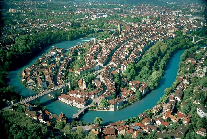
Bern
- capital of Switzerland
Hiking in Bern
Hiking in Bern, the capital of Switzerland, offers a wonderful variety of landscapes, trails, and experiences for outdoor enthusiasts. The region surrounding Bern is characterized by its picturesque countryside, rolling hills, and proximity to the imposing Bernese Alps. Here are some highlights to consider when hiking in and around Bern:...
- Country:
- Postal Code: 3000
- Local Dialing Code: 031
- Licence Plate Code: BE
- Coordinates: 46° 56' 53" N, 7° 26' 51" E
- GPS tracks (wikiloc): [Link]
- AboveSeaLevel: 542 м m
- Area: 51.62 sq km
- Population: 133798
- Web site: [Link]