Bressieux (Bressieux)
- commune in Isère, France
Bressieux, located in the Isère department of the Auvergne-Rhône-Alpes region in France, offers a variety of hiking opportunities suitable for different skill levels and preferences. The region is known for its beautiful natural landscapes, which include rolling hills, forests, and views of the surrounding mountains.
Hiking Trails
- Le Sentier des Châtaigniers: This trail takes you through chestnut forests and offers stunning views of the surrounding countryside.
- Circuit des Cimes: A more challenging trail that leads to higher elevations, providing panoramic views. It's suitable for experienced hikers.
- Les Rives du Rhône: A gentler path along the riverbanks, ideal for families and beginners.
Preparation
- Trail Conditions: Always check local trail conditions before heading out, especially during or after rainy weather, as trails may be muddy or closed.
- Equipment: Wear sturdy hiking boots, and carry a map or GPS device, plenty of water, and snacks.
- Safety: Inform someone about your hiking plan and expected return time. Also, be aware of the local wildlife and plant species.
Best Time to Hike
Spring and early autumn are typically the best times for hiking in Bressieux, as the weather is mild, and the landscapes are vibrant.
Local Highlights
In addition to hiking, explore other outdoor activities such as mountain biking, picnicking, or visiting local markets. You may also find historical sites and local cuisine to enrich your hiking experience.
Conclusion
Bressieux is a hidden gem for hikers who appreciate both nature and tranquility. Whether you’re looking for a leisurely walk or a more challenging hike, the area has something to offer for everyone. Always remember to follow the Leave No Trace principles to preserve the natural beauty of the trails. Enjoy your hike!
- Country:

- Postal Code: 38870
- Coordinates: 45° 19' 21" N, 5° 16' 36" E


- GPS tracks (wikiloc): [Link]
- Area: 0.89 sq km
- Population: 88
- Wikipedia en: wiki(en)
- Wikipedia: wiki(fr)
- Wikidata storage: Wikidata: Q649698
- Wikipedia Commons Category: [Link]
- Freebase ID: [/m/03g_6ry]
- GeoNames ID: Alt: [6455082]
- SIREN number: [213800568]
- BnF ID: [15257885b]
- VIAF ID: Alt: [235546874]
- PACTOLS thesaurus ID: [pcrtbcUIJI3yEf]
- INSEE municipality code: 38056
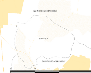
Shares border with regions:


Saint-Siméon-de-Bressieux
- commune in Isère, France
 Hiking in Saint-Siméon-de-Bressieux
Saint-Siméon-de-Bressieux is a charming village located in the Isère department in the Auvergne-Rhône-Alpes region of France. The surrounding area offers stunning natural landscapes, making it an excellent spot for hiking enthusiasts....
- Country:

- Postal Code: 38870
- Coordinates: 45° 19' 42" N, 5° 15' 42" E


- GPS tracks (wikiloc): [Link]
- Area: 18.79 sq km
- Population: 2876
- Web site: [Link]


Saint-Pierre-de-Bressieux
- commune in Isère, France
 Hiking in Saint-Pierre-de-Bressieux
Saint-Pierre-de-Bressieux is a charming commune located in the Isère department of France, nestled in the picturesque region of Auvergne-Rhône-Alpes. Hiking around this area offers beautiful landscapes, varying terrains, and opportunities to explore the local flora and fauna....
- Country:

- Postal Code: 38870
- Coordinates: 45° 18' 56" N, 5° 17' 7" E


- GPS tracks (wikiloc): [Link]
- Area: 23.08 sq km
- Population: 766
- Web site: [Link]
