Brion (Brion)

- commune in Isère, France
 Hiking in Brion
Brion, located in the Isère department of the Auvergne-Rhône-Alpes region in southeastern France, offers a variety of scenic hiking opportunities that showcase the natural beauty of the surrounding landscapes. Here are some key points to consider when hiking in Brion:
Trail Variety
- Terrain: The area features diverse terrain ranging from gentle rolling hills to more challenging mountainous paths, making it suitable for both novice and experienced hikers.
- Scenic Views: Many trails provide stunning views of the Vercors Massif and the surrounding hills, allowing hikers to immerse themselves in the picturesque scenery of the region.
Popular Hiking Routes
- Local Trails: There are several marked hiking trails in and around Brion. It's a good idea to consult local maps or tourist information centers for recommended routes.
- Vercors Regional Natural Park: If you're looking for a more extensive hiking experience, nearby Vercors Park offers numerous trails that vary in difficulty and length, suitable for day hikes and multi-day treks.
Wildlife and Flora
- Expect to encounter a variety of flora and fauna, particularly as you explore different altitudinal levels. Depending on the season, you may see wildflowers, forests, and even some local wildlife like chamois or deer.
Best Time to Hike
- Spring and Fall: These seasons are generally the most pleasant for hiking, with mild temperatures and beautiful natural colors.
- Summer: Be prepared for warmer temperatures; early morning hikes might be best to avoid the heat.
Safety and Preparation
- Equipment: Good hiking boots and suitable clothing for changing weather are essential. Carry a map, compass, or GPS device, particularly if you're venturing into less marked areas.
- Hydration and Snacks: Always bring enough water and snacks to keep your energy up during the hike.
- Local Regulations: Familiarize yourself with any local regulations, including any protected areas or trail rules.
Nearby Amenities
- Brion is a small village, so accommodations may be limited. Consider looking for nearby towns for more options, and check local sites for any guided hikes or events.
Before heading out, check updated trail conditions, and always let someone know your hiking plans for safety. Enjoy your hiking adventure in Brion!
- Country:

- Postal Code: 38590
- Coordinates: 45° 17' 34" N, 5° 20' 18" E


- GPS tracks (wikiloc): [Link]
- Area: 3.94 sq km
- Population: 138
- Web site: http://www.brion38.fr
- Wikipedia en: wiki(en)
- Wikipedia: wiki(fr)
- Wikidata storage: Wikidata: Q1002985
- Wikipedia Commons Category: [Link]
- Freebase ID: [/m/03g_6qk]
- GeoNames ID: Alt: [6613794]
- SIREN number: [213800600]
- BnF ID: [15257889q]
- INSEE municipality code: 38060
Shares border with regions:

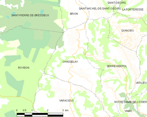
Chasselay
- commune in Isère, France
Hiking in Chasselay
Chasselay, a small commune in the Isère department in the Auvergne-Rhône-Alpes region of France, offers several opportunities for outdoor enthusiasts, especially those who enjoy hiking. The area is known for its natural beauty, with scenic landscapes that include rolling hills, forests, and panoramic views of the surrounding mountains....
- Country:
- Postal Code: 38470
- Coordinates: 45° 15' 21" N, 5° 20' 19" E
- GPS tracks (wikiloc): [Link]
- Area: 9.45 sq km
- Population: 416
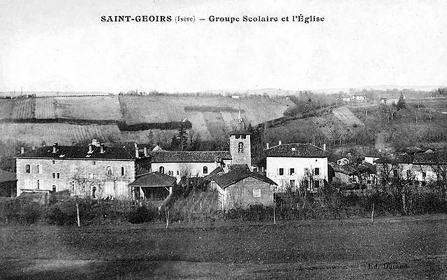

Saint-Geoirs
- commune in Isère, France
Hiking in Saint-Geoirs
Saint-Geoirs is a charming commune in the Isère department of the Auvergne-Rhône-Alpes region in southeastern France. While it's not as famous for hiking as some larger national parks or mountainous areas, there are still plenty of opportunities for outdoor enthusiasts to enjoy the natural surroundings....
- Country:
- Postal Code: 38590
- Coordinates: 45° 19' 20" N, 5° 21' 17" E
- GPS tracks (wikiloc): [Link]
- Area: 6.93 sq km
- Population: 523

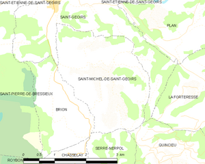
Saint-Michel-de-Saint-Geoirs
- commune in Isère, France
Hiking in Saint-Michel-de-Saint-Geoirs
Saint-Michel-de-Saint-Geoirs is a small commune located in the Isère department of the Auvergne-Rhône-Alpes region in southeastern France. While it may not be as widely known as some larger hiking destinations, it offers a variety of outdoor activities in its natural surroundings, especially for those looking to explore the beautiful scenery of the region....
- Country:
- Postal Code: 38590
- Coordinates: 45° 18' 19" N, 5° 21' 21" E
- GPS tracks (wikiloc): [Link]
- Area: 7.14 sq km
- Population: 307
- Web site: [Link]


Saint-Pierre-de-Bressieux
- commune in Isère, France
Hiking in Saint-Pierre-de-Bressieux
Saint-Pierre-de-Bressieux is a charming commune located in the Isère department of France, nestled in the picturesque region of Auvergne-Rhône-Alpes. Hiking around this area offers beautiful landscapes, varying terrains, and opportunities to explore the local flora and fauna....
- Country:
- Postal Code: 38870
- Coordinates: 45° 18' 56" N, 5° 17' 7" E
- GPS tracks (wikiloc): [Link]
- Area: 23.08 sq km
- Population: 766
- Web site: [Link]

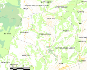
Serre-Nerpol
- commune in Isère, France
Hiking in Serre-Nerpol
Serre-Nerpol, located in the French Alps, offers a range of hiking opportunities for enthusiasts of all skill levels. Here are some key highlights and tips for hiking in this beautiful region:...
- Country:
- Postal Code: 38470
- Coordinates: 45° 15' 29" N, 5° 22' 30" E
- GPS tracks (wikiloc): [Link]
- AboveSeaLevel: 400 м m
- Area: 13.16 sq km
- Population: 293
- Web site: [Link]