Broc (Broc)

- former commune in Maine-et-Loire, France
- Country:

- Postal Code: 49490
- Coordinates: 47° 34' 46" N, 0° 9' 59" E


- GPS tracks (wikiloc): [Link]
- Area: 21.23 sq km
- Population: 318
- Wikipedia en: wiki(en)
- Wikipedia: wiki(fr)
- Wikidata storage: Wikidata: Q1164107
- Wikipedia Commons Category: [Link]
- GeoNames ID: Alt: [6449415]
- BnF ID: [152616548]
- VIAF ID: Alt: [149935340]
- INSEE municipality code: 49052
Shares border with regions:

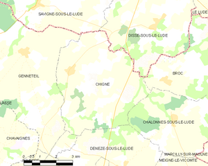
Chigné
- former commune in Maine-et-Loire, France
- Country:
- Postal Code: 49490
- Coordinates: 47° 35' 2" N, 0° 5' 14" E
- GPS tracks (wikiloc): [Link]
- Area: 25.22 sq km
- Population: 311
Chalonnes-sous-le-Lude
- former commune in Maine-et-Loire, France
- Country:
- Postal Code: 49490
- Coordinates: 47° 33' 33" N, 0° 10' 21" E
- GPS tracks (wikiloc): [Link]
- Area: 16.49 sq km
- Population: 125

Marcilly-sur-Maulne
- commune in Indre-et-Loire, France
- Country:
- Postal Code: 37330
- Coordinates: 47° 33' 3" N, 0° 14' 29" E
- GPS tracks (wikiloc): [Link]
- Area: 14.6 sq km
- Population: 235
- Web site: [Link]


La Chapelle-aux-Choux
- commune in Sarthe, France
- Country:
- Postal Code: 72800
- Coordinates: 47° 37' 56" N, 0° 13' 53" E
- GPS tracks (wikiloc): [Link]
- Area: 14.43 sq km
- Population: 269

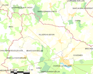
Villiers-au-Bouin
- commune in Indre-et-Loire, France
- Country:
- Postal Code: 37330
- Coordinates: 47° 34' 29" N, 0° 18' 46" E
- GPS tracks (wikiloc): [Link]
- Area: 29.83 sq km
- Population: 763


Le Lude
- commune in Sarthe, France
- Country:
- Postal Code: 72800
- Coordinates: 47° 38' 42" N, 0° 9' 11" E
- GPS tracks (wikiloc): [Link]
- Area: 45.99 sq km
- Population: 3876
- Web site: [Link]


Dissé-sous-le-Lude
- former commune in Sarthe, France
- Country:
- Postal Code: 72800
- Coordinates: 47° 36' 32" N, 0° 9' 18" E
- GPS tracks (wikiloc): [Link]
- Area: 22.37 sq km
- Population: 552