Buochs (Buochs)
- municipality in Switzerland
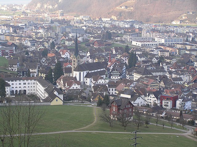
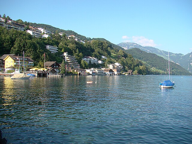
Buochs is a charming municipality located in the canton of Nidwalden in Switzerland, nestled at the northern end of Lake Lucerne. The area offers stunning natural beauty and a variety of hiking opportunities suitable for different skill levels. Here are some highlights and tips for hiking in and around Buochs:
Trails and Routes
-
Luzernerweg: This well-marked trail passes through beautiful landscapes and offers fantastic views of Lake Lucerne and the surrounding mountains. Parts of this trail can be accessed from Buochs.
-
Seelisberg: A short hike from Buochs can lead you to Seelisberg, offering panoramic views of the lake and the mountains. The trails here are family-friendly and well-marked.
-
The Swiss Path: This scenic trail runs along the shores of Lake Lucerne and connects several picturesque towns and villages, including Buochs. It's an excellent choice for those looking to enjoy a longer hike with breathtaking views.
-
Mount Rigi and Mount Pilatus: While not directly in Buochs, these iconic mountains are easily accessible and provide a network of hiking trails of varying difficulties. Consider a day trip to tackle these popular hiking destinations.
Tips for Hiking in Buochs
-
Weather Awareness: The weather in the mountains can change quickly, so it's essential to check the forecast before heading out and to dress in layers.
-
Trail Maps: Always carry a map or a GPS device. While many trails are well-marked, having a map can help you navigate and explore alternative routes.
-
Hydration and Snacks: Bring enough water and snacks to keep your energy up during hikes, as amenities can be sparse along certain trails.
-
Local Regulations: Familiarize yourself with local hiking regulations and guidelines. In some areas, staying on marked paths is crucial for protecting wildlife and vegetation.
-
Public Transport: Buochs has good public transport connections, making it easy to start or end hikes in different locations without the need for a car.
Conclusion
Buochs offers a delightful mix of easy and more challenging hikes set against the backdrop of picturesque landscapes and serene lake views. Whether you are a seasoned hiker or a novice, there's something for everyone in this beautiful region of Switzerland. Always be prepared and enjoy your hiking adventure!
- Country:

- Postal Code: 6374
- Local Dialing Code: 041
- Licence Plate Code: NW
- Coordinates: 46° 58' 29" N, 8° 25' 14" E


- GPS tracks (wikiloc): [Link]
- AboveSeaLevel: 436 м m
- Area: 12.04 sq km
- Population: 5409
- Web site: http://www.buochs.ch
- Wikipedia en: wiki(en)
- Wikipedia: wiki(de)
- Wikidata storage: Wikidata: Q64567
- Wikipedia Commons Category: [Link]
- Freebase ID: [/m/01v23m]
- GeoNames ID: Alt: [7285384]
- VIAF ID: Alt: [241851254]
- OSM relation ID: [1683062]
- TGN ID: [1063971]
- HDS ID: [748]
- Swiss municipality code: [1502]
Shares border with regions:


Stans
- municipality in, and capital of, the Swiss canton of Nidwalden
Hiking in Stans, a picturesque town in the Lucerne region of Switzerland, offers a variety of trails that cater to different skill levels and preferences. The stunning backdrop of the Swiss Alps provides a breathtaking experience, making it a popular destination for outdoor enthusiasts. Here are some key points to consider when hiking in Stans:...
- Country:

- Postal Code: 6370
- Local Dialing Code: 041
- Licence Plate Code: NW
- Coordinates: 46° 57' 34" N, 8° 22' 0" E


- GPS tracks (wikiloc): [Link]
- AboveSeaLevel: 452 м m
- Area: 11.08 sq km
- Population: 8411
- Web site: [Link]


Ennetbürgen
- municipality in Switzerland
Ennetbürgen is a picturesque village located near Lake Lucerne in the canton of Nidwalden, Switzerland. It offers a variety of hiking opportunities that immerse you in breathtaking natural landscapes, including stunning lake views and mountainous terrain. Here are some highlights and tips for hiking in and around Ennetbürgen:...
- Country:

- Postal Code: 6373
- Local Dialing Code: 041
- Licence Plate Code: NW
- Coordinates: 46° 59' 4" N, 8° 24' 50" E


- GPS tracks (wikiloc): [Link]
- AboveSeaLevel: 435 м m
- Area: 17.70 sq km
- Population: 4698
- Web site: [Link]


Gersau
- municipality in Switzerland
Gersau is a picturesque town located on the shores of Lake Lucerne in Switzerland, surrounded by stunning mountains and rich natural landscapes, making it a fantastic destination for hiking enthusiasts. Here are some highlights and tips for hiking in and around Gersau:...
- Country:

- Postal Code: 6442
- Local Dialing Code: 041
- Licence Plate Code: SZ
- Coordinates: 46° 59' 28" N, 8° 31' 29" E


- GPS tracks (wikiloc): [Link]
- AboveSeaLevel: 435 м m
- Area: 23.70 sq km
- Population: 2279
- Web site: [Link]


Oberdorf
- municipality in the canton of Nidwalden, Switzerland
Oberdorf, located in the Nidwalden canton of Switzerland, offers a beautiful setting for hiking enthusiasts. Nestled in the central part of the country, this region is known for its stunning landscapes, including rolling hills, lush forests, and picturesque views of the surrounding mountains....
- Country:

- Postal Code: 6370
- Local Dialing Code: 041
- Licence Plate Code: NW
- Coordinates: 46° 56' 33" N, 8° 24' 21" E


- GPS tracks (wikiloc): [Link]
- AboveSeaLevel: 716 м m
- Area: 16.20 sq km
- Population: 3133
- Web site: [Link]


Beckenried
- municipality in Switzerland
Beckenried, located in the canton of Nidwalden, Switzerland, is a beautiful destination for hiking enthusiasts. Nestled between Lake Lucerne and the surrounding mountains, it offers a variety of trails with stunning views, diverse landscapes, and the opportunity to explore the natural beauty of the region....
- Country:

- Postal Code: 6375
- Local Dialing Code: 041
- Licence Plate Code: NW
- Coordinates: 46° 57' 59" N, 8° 28' 29" E


- GPS tracks (wikiloc): [Link]
- AboveSeaLevel: 448 м m
- Area: 32.95 sq km
- Population: 3654
- Web site: [Link]

