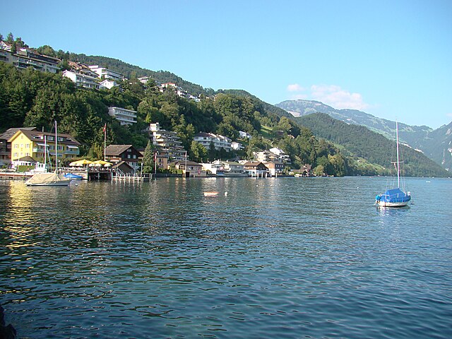
Beckenried (Beckenried)

- municipality in Switzerland
 Hiking in Beckenried
Beckenried, located in the canton of Nidwalden, Switzerland, is a beautiful destination for hiking enthusiasts. Nestled between Lake Lucerne and the surrounding mountains, it offers a variety of trails with stunning views, diverse landscapes, and the opportunity to explore the natural beauty of the region.
Hiking Trails
-
Niederbauen: A popular hike starts from Beckenried up to the Niederbauen mountain. The trail offers breathtaking views of Lake Lucerne and the central Swiss Alps. At the summit, hikers are rewarded with panoramic vistas, making it a great spot for photos and relaxation.
-
Küssnacht to Beckenried: This route follows a scenic pathway along the lakeshore and is relatively flat, making it suitable for families and less experienced hikers. It's perfect for a leisurely stroll while enjoying the views of the lake and the surrounding mountains.
-
Hiking around the Bürgenstock: A bit further, the Bürgenstock offers a variety of trails, including the famous cliff walk that provides stunning views of the Lake Lucerne region. You can reach the starting point by taking a boat from Beckenried.
-
Pilatus: While not directly in Beckenried, nearby Pilatus offers various hiking options. The trails range from easy walks to challenging hikes, and you can also take a cable car or cogwheel train to facilitate access.
Best Seasons to Hike
-
Spring (April to June): Perfect for wildflowers and milder weather, making it comfortable for hiking.
-
Summer (July to August): Ideal for longer hikes, but be prepared for higher temperatures and more foot traffic.
-
Autumn (September to October): A beautiful time to hike as the leaves change color, offering picturesque landscapes.
-
Winter (November to March): While many trails may become snow-covered, there are winter hiking options and snowshoeing in the region.
Preparing for Your Hike
-
Gear: Ensure you have proper hiking boots, clothing suitable for the weather, and navigation tools (map or GPS).
-
Water & Snacks: Always carry enough water and some snacks to keep your energy up during the hike.
-
Local Information: Check local weather conditions and trails status before heading out, as they can change rapidly.
-
Respect Nature: Stay on designated trails, respect local wildlife, and practice Leave No Trace principles.
Beckenried is a fantastic base for exploring the stunning hiking opportunities of Central Switzerland, with trails suitable for all skill levels and ample opportunities for breathtaking views. Enjoy your hike!
- Country:

- Postal Code: 6375
- Local Dialing Code: 041
- Licence Plate Code: NW
- Coordinates: 46° 57' 59" N, 8° 28' 29" E


- GPS tracks (wikiloc): [Link]
- AboveSeaLevel: 448 м m
- Area: 32.95 sq km
- Population: 3654
- Web site: http://www.beckenried.ch
- Wikipedia en: wiki(en)
- Wikipedia: wiki(de)
- Wikidata storage: Wikidata: Q69140
- Wikipedia Commons Category: [Link]
- Freebase ID: [/m/01v234]
- GeoNames ID: Alt: [7285174]
- VIAF ID: Alt: [143223785]
- OSM relation ID: [1683061]
- GND ID: Alt: [4005143-2]
- Library of Congress authority ID: Alt: [n94100869]
- Quora topic ID: [Beckenried]
- TGN ID: [1063931]
- HDS ID: [747]
- Swiss municipality code: [1501]
Shares border with regions:

Ennetbürgen
- municipality in Switzerland
Hiking in Ennetbürgen
Ennetbürgen is a picturesque village located near Lake Lucerne in the canton of Nidwalden, Switzerland. It offers a variety of hiking opportunities that immerse you in breathtaking natural landscapes, including stunning lake views and mountainous terrain. Here are some highlights and tips for hiking in and around Ennetbürgen:...
- Country:
- Postal Code: 6373
- Local Dialing Code: 041
- Licence Plate Code: NW
- Coordinates: 46° 59' 4" N, 8° 24' 50" E
- GPS tracks (wikiloc): [Link]
- AboveSeaLevel: 435 м m
- Area: 17.70 sq km
- Population: 4698
- Web site: [Link]


Wolfenschiessen
- municipality in Switzerland
Hiking in Wolfenschiessen
Wolfenschiessen is a charming village located in the Nidwalden region of Switzerland, nestled between the well-known mountains of the area. It's an excellent base for hiking enthusiasts due to its stunning natural scenery, well-marked trails, and access to the surrounding alpine landscapes....
- Country:
- Postal Code: 6386
- Local Dialing Code: 041
- Licence Plate Code: NW
- Coordinates: 46° 51' 46" N, 8° 23' 40" E
- GPS tracks (wikiloc): [Link]
- AboveSeaLevel: 1516 м m
- Area: 92.76 sq km
- Population: 2093
- Web site: [Link]


Gersau
- municipality in Switzerland
Hiking in Gersau
Gersau is a picturesque town located on the shores of Lake Lucerne in Switzerland, surrounded by stunning mountains and rich natural landscapes, making it a fantastic destination for hiking enthusiasts. Here are some highlights and tips for hiking in and around Gersau:...
- Country:
- Postal Code: 6442
- Local Dialing Code: 041
- Licence Plate Code: SZ
- Coordinates: 46° 59' 28" N, 8° 31' 29" E
- GPS tracks (wikiloc): [Link]
- AboveSeaLevel: 435 м m
- Area: 23.70 sq km
- Population: 2279
- Web site: [Link]


Buochs
- municipality in Switzerland
Hiking in Buochs
Buochs is a charming municipality located in the canton of Nidwalden in Switzerland, nestled at the northern end of Lake Lucerne. The area offers stunning natural beauty and a variety of hiking opportunities suitable for different skill levels. Here are some highlights and tips for hiking in and around Buochs:...
- Country:
- Postal Code: 6374
- Local Dialing Code: 041
- Licence Plate Code: NW
- Coordinates: 46° 58' 29" N, 8° 25' 14" E
- GPS tracks (wikiloc): [Link]
- AboveSeaLevel: 436 м m
- Area: 12.04 sq km
- Population: 5409
- Web site: [Link]

Isenthal
- municipality in Switzerland
Hiking in Isenthal
Isenthal is a beautiful valley located in the heart of Switzerland, specifically in the canton of Uri. It is known for its stunning landscapes, lush meadows, and impressive mountain views, making it a perfect destination for hiking enthusiasts. Here are some key highlights and tips for hiking in Isenthal:...
- Country:
- Postal Code: 6461
- Local Dialing Code: 041
- Licence Plate Code: UR
- Coordinates: 46° 53' 11" N, 8° 31' 28" E
- GPS tracks (wikiloc): [Link]
- AboveSeaLevel: 1404 м m
- Area: 60.99 sq km
- Population: 494
- Web site: [Link]


Oberdorf
- municipality in the canton of Nidwalden, Switzerland
Hiking in Oberdorf
Oberdorf, located in the Nidwalden canton of Switzerland, offers a beautiful setting for hiking enthusiasts. Nestled in the central part of the country, this region is known for its stunning landscapes, including rolling hills, lush forests, and picturesque views of the surrounding mountains....
- Country:
- Postal Code: 6370
- Local Dialing Code: 041
- Licence Plate Code: NW
- Coordinates: 46° 56' 33" N, 8° 24' 21" E
- GPS tracks (wikiloc): [Link]
- AboveSeaLevel: 716 м m
- Area: 16.20 sq km
- Population: 3133
- Web site: [Link]

Emmetten
- municipality in Switzerland
Hiking in Emmetten
Emmetten is a charming village located in Switzerland, offering stunning views of Lake Lucerne and the surrounding mountains, making it an excellent destination for hiking enthusiasts. Here are some key points to consider when planning a hike in Emmetten:...
- Country:
- Postal Code: 6376
- Local Dialing Code: 041
- Licence Plate Code: NW
- Coordinates: 46° 57' 24" N, 8° 31' 5" E
- GPS tracks (wikiloc): [Link]
- AboveSeaLevel: 774 м m
- Area: 28.63 sq km
- Population: 1401
- Web site: [Link]