San Sosti (San Sosti)
.svg)
- Italian comune
 Hiking in San Sosti
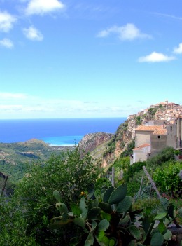
San Sosti is a charming village located in the Calabria region of southern Italy, nestled in the foothills of the Pollino National Park. This area is characterized by its stunning natural landscapes, rich biodiversity, and scenic hiking routes, making it a great destination for outdoor enthusiasts.
Hiking Trails and Areas
-
Pollino National Park: Just a short distance from San Sosti, this national park offers numerous hiking trails ranging from easy walks to more challenging hikes. The park is known for its rugged mountains, deep gorges, and ancient forests. Popular trails include the paths leading to the summit of Mount Pollino, the highest peak in southern Italy.
-
Historical and Cultural Trails: Many trails lead through picturesque villages and historical sites. You can hike through old olive groves, visit ancient churches, and experience the local culture.
-
River and Waterfall Trails: The area around San Sosti features several rivers and waterfalls. Hikes along these waterways can provide refreshing views and a tranquil atmosphere. The Fiume Mercure is one example, which offers beautiful scenery as you explore the riverbanks.
Things to Consider
-
Difficulty Levels: Trails vary in difficulty from leisurely strolls to strenuous hikes. It's essential to match your chosen trail with your fitness level and experience.
-
Weather: The best time for hiking in the San Sosti area is typically from late spring to early autumn when the weather is mild and the landscapes are lush. Summer can be hot, so it’s best to start hikes early or later in the day.
-
Safety: Ensure you have proper hiking gear, including sturdy footwear, plenty of water, and sun protection. It’s also wise to carry a map or GPS device as some areas may have limited signage.
-
Local Guidance: If you’re unfamiliar with the area, consider hiring a local guide who can enhance your experience and offer insights into the local flora, fauna, and cultural heritage.
-
Leave No Trace: Always practice Leave No Trace principles by respecting wildlife, sticking to trails, and carrying out all trash.
Conclusion
Hiking in and around San Sosti offers a wonderful opportunity to explore the natural beauty and cultural richness of Calabria. With its diverse trails and breathtaking landscapes, you’ll create lasting memories while enjoying the great outdoors. Whether you're a seasoned hiker or a casual walker, San Sosti has something to offer everyone.
- Country:

- Postal Code: 87010
- Local Dialing Code: 0981
- Licence Plate Code: CS
- Coordinates: 39° 40' 0" N, 16° 2' 0" E


- GPS tracks (wikiloc): [Link]
- AboveSeaLevel: 355 м m
- Area: 43.55 sq km
- Population: 2169
- Web site: http://www.comune.sansosti.cs.it
- Wikipedia en: wiki(en)
- Wikipedia: wiki(it)
- Wikidata storage: Wikidata: Q53981
- Wikipedia Commons Category: [Link]
- Freebase ID: [/m/04b8pf]
- GeoNames ID: Alt: [6537688]
- VIAF ID: Alt: [248791284]
- OSM relation ID: [40018]
- ISTAT ID: 078128
- Italian cadastre code: I165
Shares border with regions:


Altomonte
- Italian comune
Hiking in Altomonte
Altomonte, located in the Calabria region of southern Italy, is a charming town surrounded by beautiful landscapes that are ideal for hiking enthusiasts. The area offers a blend of scenic countryside, natural beauty, and historical features that makes it a unique destination for outdoor activities. Here are some highlights of hiking in and around Altomonte:...
- Country:
- Postal Code: 87042
- Local Dialing Code: 0981
- Licence Plate Code: CS
- Coordinates: 39° 42' 0" N, 16° 8' 0" E
- GPS tracks (wikiloc): [Link]
- AboveSeaLevel: 455 м m
- Area: 65.72 sq km
- Population: 4382
- Web site: [Link]
Buonvicino
- Italian comune
Hiking in Buonvicino
Buonvicino is a charming small town located in the Calabria region of southern Italy, known for its beautiful landscapes, mountainous terrain, and proximity to the Pollino National Park. Hiking in and around Buonvicino offers a variety of trails that cater to different skill levels, making it an ideal spot for both novice and experienced hikers. Here are some highlights for hiking in this area:...
- Country:
- Postal Code: 87020
- Local Dialing Code: 0985
- Licence Plate Code: CS
- Coordinates: 39° 41' 0" N, 15° 53' 0" E
- GPS tracks (wikiloc): [Link]
- AboveSeaLevel: 400 м m
- Area: 30.6 sq km
- Population: 2229
- Web site: [Link]

Grisolia
- Italian comune
Hiking in Grisolia
Grisolia is a beautiful location situated in the Calabria region of Italy, known for its stunning coastal views and mountainous terrain. Hiking in and around Grisolia offers a range of experiences suitable for various skill levels, with the opportunity to explore both nature and charming local culture....
- Country:
- Postal Code: 87020
- Local Dialing Code: 0985
- Licence Plate Code: CS
- Coordinates: 39° 43' 0" N, 15° 51' 0" E
- GPS tracks (wikiloc): [Link]
- AboveSeaLevel: 480 м m
- Area: 51.75 sq km
- Population: 2223
- Web site: [Link]


Malvito
- Italian comune
Hiking in Malvito
Malvito is a small village located in the Calabria region of Italy, known for its stunning landscapes and proximity to the Sila National Park. Hiking in this area offers a unique experience due to the beautiful natural surroundings, rich biodiversity, and the chance to explore traditional Calabrian culture....
- Country:
- Postal Code: 87010
- Local Dialing Code: 0984
- Licence Plate Code: CS
- Coordinates: 39° 36' 0" N, 16° 3' 0" E
- GPS tracks (wikiloc): [Link]
- AboveSeaLevel: 473 м m
- Area: 38.24 sq km
- Population: 1746
- Web site: [Link]
Mottafollone
- Italian comune
Hiking in Mottafollone
Mottafollone, located in the Calabria region of southern Italy, is a hidden gem for hiking enthusiasts. Nestled in the Sila National Park, this area offers stunning landscapes, diverse flora and fauna, and various hiking trails suitable for different skill levels. Here are some highlights for hiking in Mottafollone:...
- Country:
- Postal Code: 87010
- Local Dialing Code: 0981
- Licence Plate Code: CS
- Coordinates: 39° 39' 0" N, 16° 4' 0" E
- GPS tracks (wikiloc): [Link]
- AboveSeaLevel: 384 м m
- Area: 31.58 sq km
- Population: 1215
- Web site: [Link]
Roggiano Gravina
- Italian comune
Hiking in Roggiano Gravina
Roggiano Gravina is a charming town located in the Calabria region of southern Italy. It is surrounded by beautiful landscapes, offering a variety of hiking opportunities for both beginners and more experienced hikers. The area is characterized by its rugged terrain, picturesque views, and rich natural beauty....
- Country:
- Postal Code: 87017
- Local Dialing Code: 0984
- Licence Plate Code: CS
- Coordinates: 39° 37' 0" N, 16° 9' 0" E
- GPS tracks (wikiloc): [Link]
- AboveSeaLevel: 230 м m
- Area: 44.88 sq km
- Population: 7205
- Web site: [Link]
San Donato di Ninea
- Italian comune
Hiking in San Donato di Ninea
San Donato di Ninea is a picturesque town located in the Calabria region of southern Italy, known for its beautiful landscapes, rich history, and unique cultural heritage. Hiking in and around San Donato di Ninea offers a wonderful opportunity to explore the natural beauty of the area, as well as its historical sites....
- Country:
- Postal Code: 87010
- Local Dialing Code: 0981
- Licence Plate Code: CS
- Coordinates: 39° 43' 0" N, 16° 2' 0" E
- GPS tracks (wikiloc): [Link]
- AboveSeaLevel: 720 м m
- Area: 82.4 sq km
- Population: 1283
- Web site: [Link]