Burgkirchen an der Alz (Burgkirchen an der Alz)
- Municipality in Bavaria, Germany
 Hiking in Burgkirchen an der Alz
Burgkirchen an der Alz is a picturesque municipality located in Bavaria, Germany, and it's a great place for hiking enthusiasts. The region is characterized by its beautiful landscapes, rolling hills, and proximity to the Alz River, offering numerous trails that cater to different skill levels. Here are some highlights for hiking in and around Burgkirchen an der Alz:
Trails and Routes
-
Local Trails: There are several well-marked hiking trails in and around Burgkirchen that take you through lush forests, fields, and along the banks of the Alz River. These trails vary in length and difficulty, making them suitable for both beginners and more experienced hikers.
-
The Alz River Trail: This is a scenic route that follows the Alz River. It provides lovely views and the opportunity to enjoy the tranquil sounds of the flowing water. The trail is relatively flat and can be walked or cycled.
-
Nature and Cultural Trails: In addition to natural landscapes, some trails also allow you to explore local culture and history, taking you past historical sites and offering views of traditional Bavarian architecture.
Flora and Fauna
Hiking in this vicinity gives you a chance to appreciate the rich biodiversity of the region. Depending on the season, you may encounter various wildflowers, mushrooms, and wildlife. Birdwatching can also be rewarding here, so don’t forget your binoculars!
Tips for Hikers
- Seasonal Considerations: Spring and early summer are ideal for hiking, with pleasant temperatures and blooming flowers. Autumn offers stunning foliage, while winter can provide beautiful snowy trails if you're prepared for colder conditions.
- Trail Maps: It’s always a good idea to carry a detailed map of the trails, as some might not be extensively marked. Local tourist information centers can provide maps and additional guidance.
- Proper Gear: Ensure you wear sturdy hiking boots, and dress in layers to adjust to temperature changes. Always bring enough water and snacks, especially for longer hikes.
Nearby Attractions
After a day of hiking, you can explore Burgkirchen’s local amenities, including cafes and restaurants. Nearby towns might offer additional attractions, including historical sites or larger hiking networks.
Overall, hiking in Burgkirchen an der Alz can be a delightful experience, combining nature, exercise, and possibly some local culture along the way. Enjoy your hikes and the stunning Bavarian scenery!
- Country:

- Postal Code: 84508
- Local Dialing Code: 08679
- Coordinates: 48° 10' 0" N, 12° 43' 0" E


- GPS tracks (wikiloc): [Link]
- AboveSeaLevel: 443 м m
- Area: 46.21 sq km
- Population: 9194
- Web site: http://www.burgkirchen.de
- Wikipedia en: wiki(en)
- Wikipedia: wiki(de)
- Wikidata storage: Wikidata: Q252884
- Wikipedia Commons Category: [Link]
- Freebase ID: [/m/0dz71q]
- GeoNames ID: Alt: [2941216]
- VIAF ID: Alt: [138524656]
- OSM relation ID: [942047]
- GND ID: Alt: [4211383-0]
- archINFORM location ID: [14746]
- Library of Congress authority ID: Alt: [n93058954]
- Bavarikon ID: [ODB_A00000910]
- German municipality key: 09171113
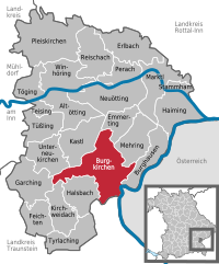
Shares border with regions:


Halsbach
- municipality of Germany
Halsbach is a small area in Germany that can be a great starting point for hiking adventures, particularly due to its proximity to natural landscapes and trails. Depending on your exact location, here are a few things you might consider:...
- Country:

- Postal Code: 84553
- Local Dialing Code: 08623
- Coordinates: 48° 7' 0" N, 12° 40' 0" E


- GPS tracks (wikiloc): [Link]
- AboveSeaLevel: 474 м m
- Area: 22.08 sq km
- Population: 866
- Web site: [Link]


Mehring
- place in Bavaria, Germany
Mehring, located in the Mosel Valley of Germany, is a charming village that offers beautiful scenery and a variety of hiking opportunities. The region is well-known for its picturesque landscapes, vineyards, and the Moselle River, making it an excellent destination for outdoor enthusiasts....
- Country:

- Postal Code: 84561
- Local Dialing Code: 08677
- Coordinates: 48° 11' 0" N, 12° 47' 0" E


- GPS tracks (wikiloc): [Link]
- AboveSeaLevel: 432 м m
- Area: 23.37 sq km
- Population: 1857
- Web site: [Link]


Kastl
- municipality of Germany
Kastl, located in Upper Bavaria, offers a charming mix of nature, culture, and history, making it a great destination for hiking enthusiasts. The surrounding landscape is characterized by rolling hills, picturesque forests, and scenic meadows that provide a variety of hiking trails suitable for different skill levels....
- Country:

- Postal Code: 84556
- Local Dialing Code: 08671
- Coordinates: 48° 12' 0" N, 12° 42' 0" E


- GPS tracks (wikiloc): [Link]
- AboveSeaLevel: 437 м m
- Area: 27.36 sq km
- Population: 1754
- Web site: [Link]


Garching an der Alz
- municipality of Germany
Garching an der Alz, located in Bavaria, Germany, is a picturesque town that offers some great opportunities for hiking and enjoying the natural beauty of the region. Here are some highlights and tips for hiking in and around Garching an der Alz:...
- Country:

- Postal Code: 84518
- Local Dialing Code: 08634
- Coordinates: 48° 7' 0" N, 12° 35' 0" E


- GPS tracks (wikiloc): [Link]
- AboveSeaLevel: 459 м m
- Area: 25.86 sq km
- Population: 7352
- Web site: [Link]


Burghausen
- town in Bavaria, Germany
Burghausen, a picturesque town in the Altötting district of Bavaria, Germany, is known for its stunning landscapes, historical sites, and extensive hiking opportunities. Situated along the Salzach River and close to the Austrian border, it offers a diverse range of hiking trails that cater to various skill levels and preferences....
- Postal Code: 84489
- Local Dialing Code: 08677
- Coordinates: 48° 10' 0" N, 12° 50' 0" E


- GPS tracks (wikiloc): [Link]
- AboveSeaLevel: 421 м m
- Area: 19.85 sq km
- Population: 16736
- Web site: [Link]


Tittmoning
- town in Bavaria, Germany
Tittmoning, located in Bavaria, Germany, is a charming town set against the backdrop of the picturesque Chiemgau Alps, making it an attractive destination for hikers. The region offers a variety of trails catering to different skill levels, from leisurely walks to more challenging hikes....
- Country:

- Postal Code: 84529
- Local Dialing Code: 08683
- Licence Plate Code: TS
- Coordinates: 48° 3' 47" N, 12° 46' 1" E


- GPS tracks (wikiloc): [Link]
- AboveSeaLevel: 388 м m
- Area: 72.01 sq km
- Population: 4947
- Web site: [Link]

Sankt Radegund
- municipality in Austria
Sankt Radegund, located in Austria near Graz, is a beautiful destination for hikers, offering a range of trails that showcase the stunning landscapes of the Styrian region. Here are some key points about hiking in Sankt Radegund:...
- Country:

- Postal Code: 5121
- Local Dialing Code: 06278
- Licence Plate Code: BR
- Coordinates: 48° 5' 48" N, 12° 45' 43" E


- GPS tracks (wikiloc): [Link]
- AboveSeaLevel: 480 м m
- Area: 17.97 sq km
- Population: 589
- Web site: [Link]


Emmerting
- municipality of Germany
Emmerting, located in Bavaria, Germany, is known for its picturesque countryside and accessibility to nature. While it may not have the extensive hiking trail networks found in larger national parks, there are opportunities for enjoyable hikes in and around the region....
- Country:

- Postal Code: 84547
- Local Dialing Code: 08679
- Coordinates: 48° 12' 0" N, 12° 46' 0" E


- GPS tracks (wikiloc): [Link]
- AboveSeaLevel: 387 м m
- Area: 14.08 sq km
- Population: 3285
- Web site: [Link]


Kirchweidach
- municipality of Germany
Kirchweidach is a charming village located in Bavaria, Germany, known for its scenic landscapes and proximity to various hiking routes. The area offers a mix of gentle hills, forests, and fields, making it ideal for hiking enthusiasts of all skill levels....
- Country:

- Postal Code: 84558
- Local Dialing Code: 08623
- Coordinates: 48° 5' 0" N, 12° 38' 0" E


- GPS tracks (wikiloc): [Link]
- AboveSeaLevel: 503 м m
- Area: 20.16 sq km
- Population: 1661
- Web site: [Link]


Unterneukirchen
- municipality of Germany
Unterneukirchen, located in Bavaria, Germany, is a picturesque area that is well-suited for hiking enthusiasts. The region is characterized by beautiful landscapes, rolling hills, and scenic views, making it a great destination for outdoor activities....
- Country:

- Postal Code: 84579
- Local Dialing Code: 08634
- Coordinates: 48° 9' 54" N, 12° 37' 7" E


- GPS tracks (wikiloc): [Link]
- AboveSeaLevel: 463 м m
- Area: 23.26 sq km
- Population: 2051
- Web site: [Link]
