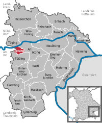
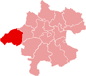
Altötting (Landkreis Altötting)

- district of Bavaria, Germany
 Hiking in Altötting
Altötting, located in Bavaria, Germany, is known for its historical significance as a pilgrimage site, but it also offers beautiful landscapes ideal for hiking enthusiasts. Here are some key highlights about hiking in the Altötting district:
Scenic Trails
- Trails: The region is home to a variety of marked hiking trails that cater to different skill levels. You can find routes that range from easy walks to more challenging hikes.
- Landscape: The area features rolling hills, forests, and picturesque countryside, making it a delightful setting for outdoor activities.
Notable Hiking Areas
- The Inn River Valley: This area provides trails along the river with beautiful views and opportunities for birdwatching and picnicking.
- The Altötting Forest: The nearby forests offer shaded trails that are particularly refreshing during warmer months.
Pilgrimage Paths
- As Altötting is a renowned pilgrimage site, some hiking trails connect to important religious and historical landmarks. Exploring these paths can give you a sense of the region's cultural heritage.
Nature and Wildlife
- Hikers may encounter diverse flora and fauna along the trails. Keep your eyes peeled for various bird species and local wildlife.
Hiking Season
- The best time to hike in Altötting is during the spring and early autumn when the weather is mild, and the scenery is vibrant. Summers can be warm, while winters may bring snow, which could impact trail accessibility.
Tips for Hikers
- Preparation: Carry plenty of water, snacks, and a map or GPS device to navigate the trails.
- Footwear: Wear sturdy hiking boots to ensure comfort and safety on varied terrains.
- Local Resources: Check with local hiking clubs or visitor centers for maps, guided hikes, and other resources to enhance your hiking experience.
Accessibility
- The district is accessible by public transport, making it easy to reach various trailheads.
Hiking in Altötting offers a perfect blend of natural beauty, cultural exploration, and a peaceful outdoor experience, making it a great destination for both casual walkers and serious hikers alike.
- Country:

- Capital: Altötting
- Licence Plate Code: AÖ
- Coordinates: 48° 15' 0" N, 12° 45' 0" E


- GPS tracks (wikiloc): [Link]
- AboveSeaLevel: 436 м m
- Area: 569.41 sq km
- Population: 94216
- Web site: http://www.landkreis-altoetting.de/
- Wikipedia en: wiki(en)
- Wikipedia: wiki(de)
- Wikidata storage: Wikidata: Q10533
- Wikipedia Commons Category: [Link]
- Wikipedia Commons Maps Category: [Link]
- Freebase ID: [/m/01bc30]
- GeoNames ID: Alt: [3220817]
- VIAF ID: Alt: [132534806]
- OSM relation ID: [62663]
- GND ID: Alt: [4001546-4]
- archINFORM location ID: [2309]
- Library of Congress authority ID: Alt: [n81093631]
- Quora topic ID: [Altötting]
- TGN ID: [7077301]
- Historical Gazetteer (GOV) ID: [adm_139171]
- Bavarikon ID: [ODB_A00000907]
- NUTS code: [DE214]
- BabelNet ID: [01197826n]
- German district key: 09171
Includes regions:


Erlbach
- municipality of Germany
Hiking in Erlbach
Erlbach, located in Bavaria, Germany, is a charming spot for hiking enthusiasts. Nestled in the scenic landscape of the Bavarian Forest, Erlbach offers a variety of trails that cater to different skill levels, making it ideal for both novices and experienced hikers....
- Country:
- Postal Code: 84567
- Local Dialing Code: 08670
- Coordinates: 48° 18' 0" N, 12° 47' 0" E
- GPS tracks (wikiloc): [Link]
- AboveSeaLevel: 451 м m
- Area: 28.14 sq km
- Population: 1200
- Web site: [Link]


Halsbach
- municipality of Germany
Hiking in Halsbach
Halsbach is a small area in Germany that can be a great starting point for hiking adventures, particularly due to its proximity to natural landscapes and trails. Depending on your exact location, here are a few things you might consider:...
- Country:
- Postal Code: 84553
- Local Dialing Code: 08623
- Coordinates: 48° 7' 0" N, 12° 40' 0" E
- GPS tracks (wikiloc): [Link]
- AboveSeaLevel: 474 м m
- Area: 22.08 sq km
- Population: 866
- Web site: [Link]


Tyrlaching
- municipality of Germany
Hiking in Tyrlaching
Tyrlaching is a small village located in the Upper Bavaria region of Germany, near the border with Austria. The surrounding area is characterized by beautiful landscapes, rolling hills, and scenic views that make it an appealing destination for hiking enthusiasts. While it may not be as well-known as other hiking destinations in Bavaria, it offers a peaceful and picturesque setting for outdoor activities....
- Country:
- Postal Code: 84558
- Local Dialing Code: 08623
- Coordinates: 48° 4' 0" N, 12° 40' 0" E
- GPS tracks (wikiloc): [Link]
- AboveSeaLevel: 523 м m
- Area: 20.54 sq km
- Population: 861
- Web site: [Link]

Pleiskirchen
- municipality of Germany
Hiking in Pleiskirchen
Pleiskirchen is a charming municipality located in Bavaria, Germany. The surrounding region offers some lovely hiking opportunities, characterized by rolling hills, picturesque landscapes, and beautiful natural scenery. Here are a few key points to consider when hiking in and around Pleiskirchen:...
- Country:
- Postal Code: 84568
- Local Dialing Code: 08635
- Coordinates: 48° 18' 0" N, 12° 36' 0" E
- GPS tracks (wikiloc): [Link]
- AboveSeaLevel: 450 м m
- Area: 52.59 sq km
- Population: 2127
- Web site: [Link]

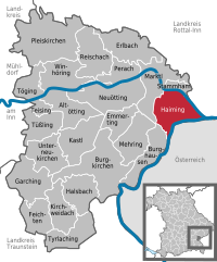
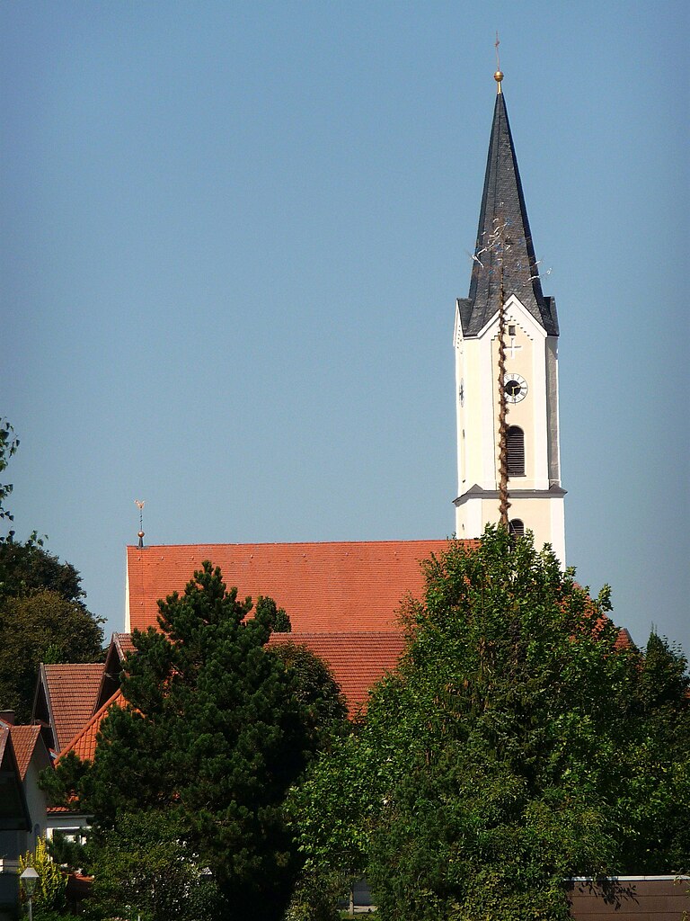
Haiming
- municipality of Germany
Hiking in Haiming
Haiming, located in Bavaria, Germany, is an excellent destination for hiking enthusiasts. Nestled close to the Alps, it offers picturesque landscapes, beautiful trails, and a variety of outdoor activities. Here are some highlights about hiking in and around Haiming:...
- Country:
- Postal Code: 84533
- Local Dialing Code: 08678
- Coordinates: 48° 12' 45" N, 12° 53' 16" E
- GPS tracks (wikiloc): [Link]
- AboveSeaLevel: 363 м m
- Area: 28.67 sq km
- Population: 2103
- Web site: [Link]

Mehring
- place in Bavaria, Germany
Hiking in Mehring
Mehring, located in the Mosel Valley of Germany, is a charming village that offers beautiful scenery and a variety of hiking opportunities. The region is well-known for its picturesque landscapes, vineyards, and the Moselle River, making it an excellent destination for outdoor enthusiasts....
- Country:
- Postal Code: 84561
- Local Dialing Code: 08677
- Coordinates: 48° 11' 0" N, 12° 47' 0" E
- GPS tracks (wikiloc): [Link]
- AboveSeaLevel: 432 м m
- Area: 23.37 sq km
- Population: 1857
- Web site: [Link]


Tüßling
- human settlement in Germany
Hiking in Tüßling
Tüßling is a charming town located in Bavaria, Germany, near the banks of the River Alz. The surrounding areas offer various opportunities for hiking and enjoying nature. Here are some aspects to consider when hiking in and around Tüßling:...
- Country:
- Postal Code: 84577
- Local Dialing Code: 08633
- Coordinates: 48° 13' 0" N, 12° 35' 0" E
- GPS tracks (wikiloc): [Link]
- AboveSeaLevel: 410 м m
- Area: 19.57 sq km
- Population: 2396
- Web site: [Link]

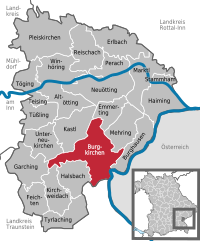
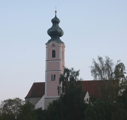
Burgkirchen an der Alz
- Municipality in Bavaria, Germany
Hiking in Burgkirchen an der Alz
Burgkirchen an der Alz is a picturesque municipality located in Bavaria, Germany, and it's a great place for hiking enthusiasts. The region is characterized by its beautiful landscapes, rolling hills, and proximity to the Alz River, offering numerous trails that cater to different skill levels. Here are some highlights for hiking in and around Burgkirchen an der Alz:...
- Country:
- Postal Code: 84508
- Local Dialing Code: 08679
- Coordinates: 48° 10' 0" N, 12° 43' 0" E
- GPS tracks (wikiloc): [Link]
- AboveSeaLevel: 443 м m
- Area: 46.21 sq km
- Population: 9194
- Web site: [Link]

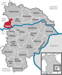
Töging am Inn
- town in Bavaria, Germany
Hiking in Töging am Inn
Töging am Inn, situated in Bavaria, Germany, is a charming town that offers various hiking opportunities for outdoor enthusiasts. The region is characterized by its scenic landscapes, rivers, and access to the surrounding areas of the Inn River Valley and the foothills of the Alps....
- Country:
- Postal Code: 84513
- Local Dialing Code: 08631
- Coordinates: 48° 15' 0" N, 12° 34' 0" E
- GPS tracks (wikiloc): [Link]
- AboveSeaLevel: 397 м m
- Area: 13.65 sq km
- Population: 8499
- Web site: [Link]


Reischach
- municipality of Germany
Hiking in Reischach
Reischach, a charming village located in the South Tyrol region of northern Italy, is a popular destination for hiking enthusiasts. Nestled in the beautiful Dolomites, it offers stunning scenery, diverse trails, and a variety of difficulty levels suitable for hikers of all ages and skill levels....
- Country:
- Postal Code: 84571
- Local Dialing Code: 08670
- Coordinates: 48° 17' 0" N, 12° 44' 0" E
- GPS tracks (wikiloc): [Link]
- AboveSeaLevel: 419 м m
- Area: 28.46 sq km
- Population: 2309
- Web site: [Link]


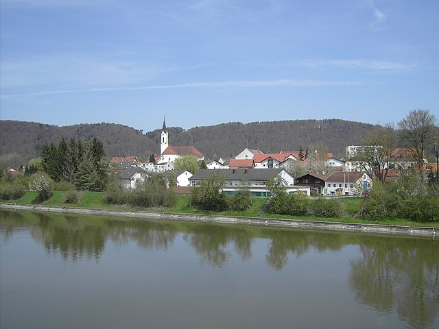
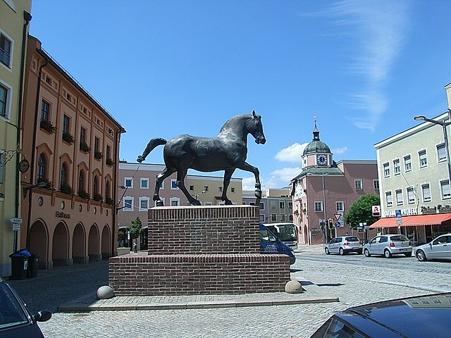
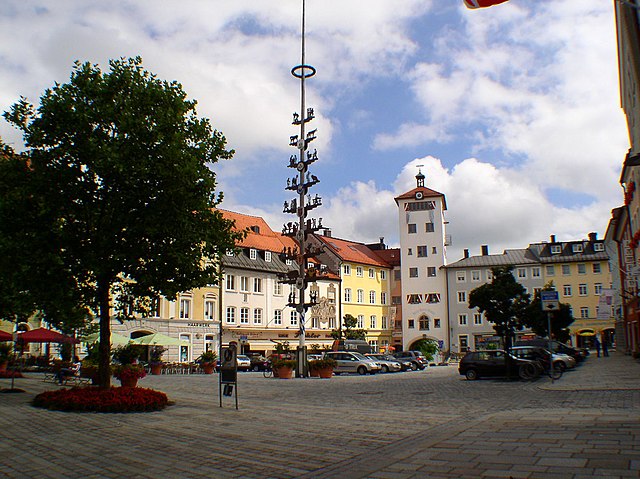
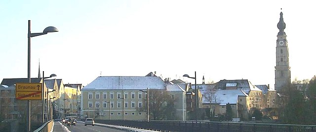
Altötting
- town in Bavaria, Germany
Hiking in Altötting
Altötting, located in Bavaria, Germany, is not only a significant pilgrimage site but also offers beautiful hiking opportunities in the surrounding areas. The landscape is characterized by rolling hills, lush forests, and scenic views, making it ideal for outdoor enthusiasts....
- Country:
- Postal Code: 84503
- Local Dialing Code: 08671
- Coordinates: 48° 13' 36" N, 12° 40' 42" E
- GPS tracks (wikiloc): [Link]
- AboveSeaLevel: 398 м m
- Area: 23.08 sq km
- Population: 12750
- Web site: [Link]

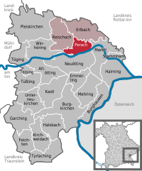
Perach
- municipality of Germany
Hiking in Perach
Perach is a small village in southern Israel, situated near the edge of the Negev Desert. While it's not traditionally known as a major hiking destination, the surrounding region offers some interesting trails and natural beauty. Here are a few highlights for hiking in and around Perach:...
- Country:
- Postal Code: 84567
- Local Dialing Code: 08670
- Coordinates: 48° 16' 0" N, 12° 46' 0" E
- GPS tracks (wikiloc): [Link]
- AboveSeaLevel: 380 м m
- Area: 14.13 sq km
- Population: 1085
- Web site: [Link]


Kastl
- municipality of Germany
Hiking in Kastl
Kastl, located in Upper Bavaria, offers a charming mix of nature, culture, and history, making it a great destination for hiking enthusiasts. The surrounding landscape is characterized by rolling hills, picturesque forests, and scenic meadows that provide a variety of hiking trails suitable for different skill levels....
- Country:
- Postal Code: 84556
- Local Dialing Code: 08671
- Coordinates: 48° 12' 0" N, 12° 42' 0" E
- GPS tracks (wikiloc): [Link]
- AboveSeaLevel: 437 м m
- Area: 27.36 sq km
- Population: 1754
- Web site: [Link]

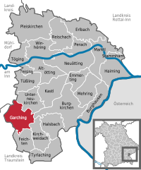
Garching an der Alz
- municipality of Germany
Hiking in Garching an der Alz
Garching an der Alz, located in Bavaria, Germany, is a picturesque town that offers some great opportunities for hiking and enjoying the natural beauty of the region. Here are some highlights and tips for hiking in and around Garching an der Alz:...
- Country:
- Postal Code: 84518
- Local Dialing Code: 08634
- Coordinates: 48° 7' 0" N, 12° 35' 0" E
- GPS tracks (wikiloc): [Link]
- AboveSeaLevel: 459 м m
- Area: 25.86 sq km
- Population: 7352
- Web site: [Link]


Burghausen
- town in Bavaria, Germany
Hiking in Burghausen
Burghausen, a picturesque town in the Altötting district of Bavaria, Germany, is known for its stunning landscapes, historical sites, and extensive hiking opportunities. Situated along the Salzach River and close to the Austrian border, it offers a diverse range of hiking trails that cater to various skill levels and preferences....
- Postal Code: 84489
- Local Dialing Code: 08677
- Coordinates: 48° 10' 0" N, 12° 50' 0" E
- GPS tracks (wikiloc): [Link]
- AboveSeaLevel: 421 м m
- Area: 19.85 sq km
- Population: 16736
- Web site: [Link]


Winhöring
- municipality of Germany
Hiking in Winhöring
Winhöring is a lovely area located in Bavaria, Germany, known for its picturesque landscapes and outdoor activities, including hiking. While it's a smaller region, it offers a variety of trails suitable for different skill levels, allowing hikers to enjoy the beautiful scenery of the Bavarian countryside....
- Country:
- Postal Code: 84543
- Local Dialing Code: 08671
- Coordinates: 48° 16' 0" N, 12° 39' 0" E
- GPS tracks (wikiloc): [Link]
- AboveSeaLevel: 389 м m
- Area: 24.58 sq km
- Population: 4500
- Web site: [Link]

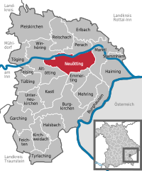
Neuötting
- town in Bavaria, Germany
Hiking in Neuötting
Neuötting, located in Bavaria, Germany, is not only rich in history but also offers some beautiful landscapes suitable for hiking. The area around Neuötting features a mix of flat terrains, gentle hills, and scenic views, making it accessible for hikers of all skill levels....
- Country:
- Postal Code: 84524
- Local Dialing Code: 08671
- Coordinates: 48° 13' 0" N, 12° 41' 0" E
- GPS tracks (wikiloc): [Link]
- AboveSeaLevel: 371 м m
- Area: 36.6 sq km
- Population: 7570
- Web site: [Link]

Marktl
- municipality of Germany
Hiking in Marktl
Marktl, a small town in Bavaria, Germany, is located near the banks of the River Alz. It's surrounded by picturesque landscapes that offer opportunities for hiking and enjoying nature....
- Country:
- Postal Code: 84533
- Local Dialing Code: 08678
- Coordinates: 48° 15' 12" N, 12° 50' 35" E
- GPS tracks (wikiloc): [Link]
- AboveSeaLevel: 362 м m
- Area: 27.84 sq km
- Population: 2665
- Web site: [Link]


Feichten
- municipality of Germany
Hiking in Feichten
Feichten is a charming village located in the Zillertal Valley of Austria, surrounded by beautiful alpine scenery. It serves as a fantastic base for hiking enthusiasts looking to explore the breathtaking landscapes of the Zillertal Alps. Here are some key points to consider when planning a hiking trip in Feichten:...
- Country:
- Postal Code: 84550
- Local Dialing Code: 08623
- Coordinates: 48° 5' 0" N, 12° 36' 0" E
- GPS tracks (wikiloc): [Link]
- AboveSeaLevel: 520 м m
- Area: 17.91 sq km
- Population: 948
- Web site: [Link]


Emmerting
- municipality of Germany
Hiking in Emmerting
Emmerting, located in Bavaria, Germany, is known for its picturesque countryside and accessibility to nature. While it may not have the extensive hiking trail networks found in larger national parks, there are opportunities for enjoyable hikes in and around the region....
- Country:
- Postal Code: 84547
- Local Dialing Code: 08679
- Coordinates: 48° 12' 0" N, 12° 46' 0" E
- GPS tracks (wikiloc): [Link]
- AboveSeaLevel: 387 м m
- Area: 14.08 sq km
- Population: 3285
- Web site: [Link]


Kirchweidach
- municipality of Germany
Hiking in Kirchweidach
Kirchweidach is a charming village located in Bavaria, Germany, known for its scenic landscapes and proximity to various hiking routes. The area offers a mix of gentle hills, forests, and fields, making it ideal for hiking enthusiasts of all skill levels....
- Country:
- Postal Code: 84558
- Local Dialing Code: 08623
- Coordinates: 48° 5' 0" N, 12° 38' 0" E
- GPS tracks (wikiloc): [Link]
- AboveSeaLevel: 503 м m
- Area: 20.16 sq km
- Population: 1661
- Web site: [Link]

Teising
- municipality of Germany
Hiking in Teising
Teising is a district in the town of Plattling, located in Bavaria, Germany. While it may not be as widely recognized as some major hiking destinations, the area surrounding Plattling and the Bavarian Forest offers beautiful landscapes and opportunities for hiking enthusiasts. Here are some highlights when it comes to hiking in and around Teising:...
- Country:
- Postal Code: 84576
- Local Dialing Code: 08633
- Coordinates: 48° 14' 0" N, 12° 37' 0" E
- GPS tracks (wikiloc): [Link]
- AboveSeaLevel: 405 м m
- Area: 5.38 sq km
- Population: 1477
- Web site: [Link]


Stammham
- human settlement in Germany
Hiking in Stammham
Stammham, located in the Altötting district of Bavaria, Germany, offers a variety of scenic hiking opportunities. The region is primarily characterized by its picturesque landscapes, charming villages, and mixed forests, making it ideal for outdoor activities....
- Country:
- Postal Code: 84533
- Local Dialing Code: 08678
- Coordinates: 48° 15' 0" N, 12° 53' 0" E
- GPS tracks (wikiloc): [Link]
- AboveSeaLevel: 369 м m
- Area: 5.67 sq km
- Population: 947
- Web site: [Link]


Unterneukirchen
- municipality of Germany
Hiking in Unterneukirchen
Unterneukirchen, located in Bavaria, Germany, is a picturesque area that is well-suited for hiking enthusiasts. The region is characterized by beautiful landscapes, rolling hills, and scenic views, making it a great destination for outdoor activities....
- Country:
- Postal Code: 84579
- Local Dialing Code: 08634
- Coordinates: 48° 9' 54" N, 12° 37' 7" E
- GPS tracks (wikiloc): [Link]
- AboveSeaLevel: 463 м m
- Area: 23.26 sq km
- Population: 2051
- Web site: [Link]
Shares border with regions:
Rottal-Inn
- district of Bavaria, Germany
Hiking in Rottal-Inn
Rottal-Inn, located in Bavaria, Germany, is a picturesque area known for its natural beauty and diverse landscapes, making it an excellent destination for hiking enthusiasts. The region is characterized by rolling hills, lush forests, and charming villages, providing a variety of hiking trails suitable for all skill levels. Here are some highlights to consider when hiking in Rottal-Inn:...
- Country:
- Capital: Pfarrkirchen
- Licence Plate Code: PAN; VIB; GRI; EG
- Coordinates: 48° 25' 12" N, 12° 55' 12" E
- GPS tracks (wikiloc): [Link]
- AboveSeaLevel: 461 м m
- Area: 1.28 sq km
- Population: 104013
- Web site: [Link]
Traunstein
- district of Bavaria, Germany
Hiking in Traunstein
Traunstein, located in Bavaria, Germany, is a beautiful area known for its picturesque landscapes, charming villages, and a variety of hiking opportunities. The region is characterized by its rolling hills, mountains, and lakes, making it ideal for outdoor enthusiasts. Here are some highlights for hiking in Traunstein:...
- Country:
- Capital: Traunstein
- Licence Plate Code: TS
- Coordinates: 47° 53' 24" N, 12° 34' 48" E
- GPS tracks (wikiloc): [Link]
- AboveSeaLevel: 560 м m
- Area: 1533.92 sq km
- Population: 145408
- Web site: [Link]

Mühldorf
- district of Bavaria, Germany
Hiking in Mühldorf
Mühldorf District, located in Bavaria, Germany, offers a range of hiking opportunities that cater to different skill levels and preferences. The area features scenic landscapes, including rolling hills, forests, and rivers, making it an attractive destination for nature lovers and outdoor enthusiasts....
- Country:
- Capital: Mühldorf
- Licence Plate Code: MÜ
- Coordinates: 48° 15' 0" N, 12° 25' 12" E
- GPS tracks (wikiloc): [Link]
- AboveSeaLevel: 447 м m
- Area: 805.32 sq km
- Population: 92882
Braunau am Inn District
- district of Austria
Hiking in Braunau am Inn District
Braunau am Inn District, located in Austria near the border with Germany, offers a variety of hiking opportunities that cater to different skill levels and preferences. The landscape is characterized by rolling hills, lush greenery, and scenic views, making it an attractive destination for nature lovers and outdoor enthusiasts....
- Country:

- Capital: Braunau am Inn
- Licence Plate Code: BR
- Coordinates: 48° 7' 52" N, 13° 6' 32" E
- GPS tracks (wikiloc): [Link]
- AboveSeaLevel: 451 м m
- Area: 1040.38 sq km
- Web site: [Link]