Tittmoning (Tittmoning)

- town in Bavaria, Germany
 Hiking in Tittmoning
Tittmoning, located in Bavaria, Germany, is a charming town set against the backdrop of the picturesque Chiemgau Alps, making it an attractive destination for hikers. The region offers a variety of trails catering to different skill levels, from leisurely walks to more challenging hikes.
Popular Hiking Trails:
-
Tittmoning to the Chiemsee:
- This trail leads you to the stunning Chiemsee, where you can enjoy beautiful lake views. The route is mostly flat and suitable for families and beginners.
-
Hiking to the Salzach River:
- A scenic trail along the Salzach River provides a peaceful environment for walking. You can appreciate the natural beauty and observe local wildlife along the way.
-
Local Nature Trails:
- There are several local nature trails that provide educational signage about the flora and fauna of the region. These trails are generally well-marked and appropriate for all ages.
-
Alpine Hikes:
- For more experienced hikers, nearby trails lead into the Alps, offering more strenuous hikes with rewarding panoramic views. These trails may have elevation gain and uneven terrain, so proper gear and preparation are recommended.
Hiking Tips:
- Weather: Always check the weather forecast before heading out, as conditions can change rapidly in the mountains.
- Gear: Wear appropriate hiking shoes and bring layers, as temperatures can vary significantly.
- Hydration and Snacks: Carry enough water and snacks, especially for longer hikes.
- Trail Maps: Consider bringing a local trail map or using a hiking app for navigation, as some trails might not be well-marked.
Additional Activities:
- After hiking, Tittmoning has lovely cafes and restaurants where you can sample local Bavarian cuisine.
- The historic town center features quaint architecture and possibly some cultural events or festivals, especially in the summer months.
Hiking in Tittmoning, with its stunning natural scenery and well-maintained trails, provides a fantastic outdoor experience for nature lovers and adventure seekers alike!
- Country:

- Postal Code: 84529
- Local Dialing Code: 08683
- Licence Plate Code: TS
- Coordinates: 48° 3' 47" N, 12° 46' 1" E


- GPS tracks (wikiloc): [Link]
- AboveSeaLevel: 388 м m
- Area: 72.01 sq km
- Population: 4947
- Web site: http://www.tittmoning.de
- Wikipedia en: wiki(en)
- Wikipedia: wiki(de)
- Wikidata storage: Wikidata: Q505158
- Wikipedia Commons Category: [Link]
- Freebase ID: [/m/0fk1cz]
- GeoNames ID: Alt: [2822075]
- VIAF ID: Alt: [235030423]
- OSM relation ID: [941656]
- GND ID: Alt: [4060258-8]
- archINFORM location ID: [13363]
- Quora topic ID: [Tittmoning]
- Bavarikon ID: [ODB_A00001380]
- German municipality key: 09189152
Shares border with regions:


Halsbach
- municipality of Germany
Hiking in Halsbach
Halsbach is a small area in Germany that can be a great starting point for hiking adventures, particularly due to its proximity to natural landscapes and trails. Depending on your exact location, here are a few things you might consider:...
- Country:
- Postal Code: 84553
- Local Dialing Code: 08623
- Coordinates: 48° 7' 0" N, 12° 40' 0" E
- GPS tracks (wikiloc): [Link]
- AboveSeaLevel: 474 м m
- Area: 22.08 sq km
- Population: 866
- Web site: [Link]

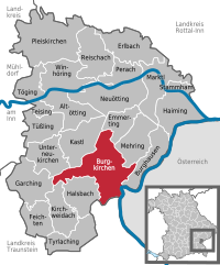
Burgkirchen an der Alz
- Municipality in Bavaria, Germany
Hiking in Burgkirchen an der Alz
Burgkirchen an der Alz is a picturesque municipality located in Bavaria, Germany, and it's a great place for hiking enthusiasts. The region is characterized by its beautiful landscapes, rolling hills, and proximity to the Alz River, offering numerous trails that cater to different skill levels. Here are some highlights for hiking in and around Burgkirchen an der Alz:...
- Country:
- Postal Code: 84508
- Local Dialing Code: 08679
- Coordinates: 48° 10' 0" N, 12° 43' 0" E
- GPS tracks (wikiloc): [Link]
- AboveSeaLevel: 443 м m
- Area: 46.21 sq km
- Population: 9194
- Web site: [Link]

Taching am See
- municipality of Germany
Hiking in Taching am See
Taching am See is a picturesque village located in Bavaria, Germany, near the shores of Lake Tachinger See. It offers beautiful landscapes, lush greenery, and opportunities for outdoor activities, making it an ideal destination for hiking enthusiasts....
- Country:
- Postal Code: 83373
- Local Dialing Code: 08681
- Licence Plate Code: TS
- Coordinates: 47° 57' 34" N, 12° 43' 46" E
- GPS tracks (wikiloc): [Link]
- AboveSeaLevel: 478 м m
- Area: 26.76 sq km
- Population: 1657
- Web site: [Link]

Fridolfing
- municipality of Germany
Hiking in Fridolfing
Fridolfing is a small municipality located in Bavaria, Germany, near the border with Austria. While it may not be as widely known as other hiking destinations, it offers some charming natural landscapes and opportunities for outdoor activities. Here are some points to consider when hiking in and around Fridolfing:...
- Country:
- Postal Code: 83413
- Local Dialing Code: 08684
- Licence Plate Code: TS
- Coordinates: 48° 0' 0" N, 12° 49' 0" E
- GPS tracks (wikiloc): [Link]
- AboveSeaLevel: 388 м m
- Area: 44.22 sq km
- Population: 3326
- Web site: [Link]

Palling
- municipality of Germany
Hiking in Palling
Palling, located in Bavaria, Germany, offers some beautiful hiking opportunities amidst stunning natural landscapes. While not as well-known as some other hiking destinations in Germany, it provides a peaceful environment that is perfect for outdoor enthusiasts looking for less crowded trails....
- Country:
- Postal Code: 83349
- Local Dialing Code: 08629
- Licence Plate Code: TS
- Coordinates: 48° 0' 0" N, 12° 38' 0" E
- GPS tracks (wikiloc): [Link]
- AboveSeaLevel: 531 м m
- Area: 53.83 sq km
- Population: 2905
- Web site: [Link]

Sankt Radegund
- municipality in Austria
Hiking in Sankt Radegund
Sankt Radegund, located in Austria near Graz, is a beautiful destination for hikers, offering a range of trails that showcase the stunning landscapes of the Styrian region. Here are some key points about hiking in Sankt Radegund:...
- Country:

- Postal Code: 5121
- Local Dialing Code: 06278
- Licence Plate Code: BR
- Coordinates: 48° 5' 48" N, 12° 45' 43" E
- GPS tracks (wikiloc): [Link]
- AboveSeaLevel: 480 м m
- Area: 17.97 sq km
- Population: 589
- Web site: [Link]

Ostermiething
- municipality in Austria
Hiking in Ostermiething
Ostermiething, a charming municipality located in Upper Austria, offers beautiful landscapes and a variety of hiking opportunities for nature lovers. The region is characterized by its scenic countryside, rolling hills, and lush forests, making it a great destination for both casual walkers and more experienced hikers....
- Country:
- Postal Code: 5121
- Local Dialing Code: 06278
- Licence Plate Code: BR
- Coordinates: 48° 2' 50" N, 12° 49' 50" E
- GPS tracks (wikiloc): [Link]
- AboveSeaLevel: 423 м m
- Area: 21.76 sq km
- Population: 3296
- Web site: [Link]