Burnhaupt-le-Bas (Burnhaupt-le-Bas)

- commune in Haut-Rhin, France
 Hiking in Burnhaupt-le-Bas
Burnhaupt-le-Bas is a charming village located in the Alsace region of northeastern France, known for its rich natural scenery and beautiful hiking opportunities. While it may not be as widely recognized as some of the larger hiking destinations in the region, it offers several attractive trails and is a great starting point for outdoor activities.
Hiking Trails:
-
Local Trails: The area around Burnhaupt-le-Bas features various local hiking paths that wind through scenic landscapes, including forests, fields, and vineyards. These trails are generally well-marked and suitable for all skill levels.
-
Nearby Natural Parks: The nearby Ballons des Vosges Regional Natural Park offers a broader range of hiking opportunities, including more challenging hikes with stunning views of the Vosges Mountains. The park features numerous well-maintained trails, and you can find routes that lead to panoramic viewpoints and picturesque sites.
-
Historical and Cultural Routes: Some trails may incorporate historical or cultural elements, allowing hikers to experience the local heritage, such as old farms, chapels, and traditional Alsatian architecture.
Important Considerations:
-
Seasonal Considerations: The best time for hiking in this area is generally spring through autumn when the weather is mild and the trails are accessible. Winter hiking can also be enjoyable, but you should be prepared for different weather conditions and trail conditions.
-
Equipment: Depending on the season and terrain, proper hiking boots, weather-appropriate clothing, and sufficient water and snacks are essential. If you plan to hike in the regional park, consider carrying a detailed map or a GPS device.
-
Local Guidance: If you are unfamiliar with the area, consider joining a guided hike or checking in with local hiking clubs or tourist information centers for maps and recommendations.
Accessibility:
Burnhaupt-le-Bas is relatively accessible by car or public transport, making it a convenient base for exploring the surrounding area. As you hike, enjoy the lovely scenery, the peaceful environment, and the unique charm of the Alsace region.
Whether you're looking for a leisurely stroll or a more strenuous hike, Burnhaupt-le-Bas offers a variety of options that highlight the natural beauty of Alsace.
- Country:

- Postal Code: 68520
- Coordinates: 47° 43' 4" N, 7° 9' 42" E


- GPS tracks (wikiloc): [Link]
- Area: 11.77 sq km
- Population: 1849
- Web site: http://burnhaupt.free.fr
- Wikipedia en: wiki(en)
- Wikipedia: wiki(fr)
- Wikidata storage: Wikidata: Q367694
- Wikipedia Commons Category: [Link]
- Freebase ID: [/m/03nss2f]
- Freebase ID: [/m/03nss2f]
- GeoNames ID: Alt: [3029499]
- GeoNames ID: Alt: [3029499]
- SIREN number: [216800599]
- SIREN number: [216800599]
- BnF ID: [152717611]
- BnF ID: [152717611]
- VIAF ID: Alt: [264449625]
- VIAF ID: Alt: [264449625]
- PACTOLS thesaurus ID: [pcrtrw7xItYjYn]
- PACTOLS thesaurus ID: [pcrtrw7xItYjYn]
- SUDOC authorities ID: [112023088]
- SUDOC authorities ID: [112023088]
- INSEE municipality code: 68059
- INSEE municipality code: 68059
Shares border with regions:
Ammertzwiller
- former commune in Haut-Rhin, France
Hiking in Ammertzwiller
Ammertzwiller is a small commune located in the Alsace region of France, near the border with Switzerland. While it may not be as famous as some of the more well-known hiking destinations, there are opportunities for hiking in and around Ammertzwiller that can be quite enjoyable....
- Country:
- Postal Code: 68210
- Coordinates: 47° 41' 20" N, 7° 10' 2" E
- GPS tracks (wikiloc): [Link]
- Area: 3.05 sq km
- Population: 469

Reiningue
- commune in Haut-Rhin, France
Hiking in Reiningue
Reiningue is a small commune in the Grand Est region of France, close to the border with Germany. While it may not be as widely recognized as a hiking destination, the surrounding region offers some beautiful natural landscapes and hiking opportunities....
- Country:
- Postal Code: 68950
- Coordinates: 47° 45' 2" N, 7° 13' 53" E
- GPS tracks (wikiloc): [Link]
- Area: 18.54 sq km
- Population: 1965
- Web site: [Link]

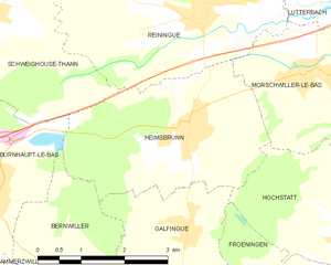
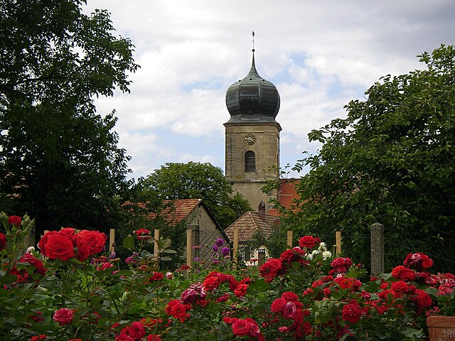
Heimsbrunn
- commune in Haut-Rhin, France
Hiking in Heimsbrunn
Heimsbrunn is a small commune located in the Grand Est region of France, specifically in the Haut-Rhin department. It offers some beautiful hiking opportunities, particularly for those looking to explore the scenic landscapes of the Vosges region. While Heimsbrunn itself is a quieter area, it is well-situated near more extensive hiking trails and natural attractions....
- Country:
- Postal Code: 68990
- Coordinates: 47° 43' 35" N, 7° 13' 35" E
- GPS tracks (wikiloc): [Link]
- Area: 10.59 sq km
- Population: 1302


Gildwiller
- commune in Haut-Rhin, France
Hiking in Gildwiller
Gildwiller is a small village in the Alsace region of France. While it may not be as well-known for hiking as some larger areas, it offers a picturesque landscape and a peaceful environment that can delight outdoor enthusiasts....
- Country:
- Postal Code: 68210
- Coordinates: 47° 41' 22" N, 7° 8' 3" E
- GPS tracks (wikiloc): [Link]
- AboveSeaLevel: 295 м m
- Area: 5.02 sq km
- Population: 283

Bernwiller
- commune in Haut-Rhin, France
Hiking in Bernwiller
Bernwiller is a charming village located in the Alsace region of France, near Mulhouse. The surrounding area is known for its picturesque landscapes, rolling hills, and vineyards, making it an appealing destination for hiking enthusiasts....
- Country:
- Postal Code: 68210
- Coordinates: 47° 41' 29" N, 7° 11' 27" E
- GPS tracks (wikiloc): [Link]
- Area: 10.65 sq km
- Population: 687


Burnhaupt-le-Haut
- commune in Haut-Rhin, France
Hiking in Burnhaupt-le-Haut
Burnhaupt-le-Haut is a small commune located in the Alsace region of northeastern France. It offers picturesque landscapes and opportunities for hiking enthusiasts to explore the surrounding natural beauty....
- Country:
- Postal Code: 68520
- Coordinates: 47° 43' 49" N, 7° 8' 43" E
- GPS tracks (wikiloc): [Link]
- Area: 12.49 sq km
- Population: 1807


Soppe-le-Bas
- commune in Haut-Rhin, France
Hiking in Soppe-le-Bas
Soppe-le-Bas is a small commune located in the Haute-Saône department in the Bourgogne-Franche-Comté region of eastern France. While it may not be one of the most famous hiking destinations in France, it offers opportunities for outdoor enthusiasts to explore the beautiful rural landscapes of the region....
- Country:
- Postal Code: 68780
- Coordinates: 47° 43' 2" N, 7° 5' 22" E
- GPS tracks (wikiloc): [Link]
- Area: 5.68 sq km
- Population: 770


Schweighouse-Thann
- commune in Haut-Rhin, France
Hiking in Schweighouse-Thann
Schweighouse-Thann is located in the Alsace region of France, near the Vosges Mountains. It's a beautiful area that offers a variety of hiking opportunities catering to different skill levels, from leisurely walks to more challenging hikes....
- Country:
- Postal Code: 68520
- Coordinates: 47° 45' 10" N, 7° 10' 15" E
- GPS tracks (wikiloc): [Link]
- AboveSeaLevel: 380 м m
- Area: 10.78 sq km
- Population: 778