Busnes (Busnes)

- commune in Pas-de-Calais, France
- Country:

- Postal Code: 62350
- Coordinates: 50° 35' 16" N, 2° 31' 6" E


- GPS tracks (wikiloc): [Link]
- Area: 9.55 sq km
- Population: 1289
- Web site: http://www.villagedebusnes.fr
- Wikipedia en: wiki(en)
- Wikipedia: wiki(fr)
- Wikidata storage: Wikidata: Q853004
- Wikipedia Commons Category: [Link]
- Freebase ID: [/m/02x822s]
- GeoNames ID: Alt: [6439417]
- SIREN number: [216201905]
- BnF ID: [15268632n]
- INSEE municipality code: 62190
Shares border with regions:


Saint-Venant
- commune in Pas-de-Calais, France
- Country:
- Postal Code: 62350
- Coordinates: 50° 37' 20" N, 2° 32' 40" E
- GPS tracks (wikiloc): [Link]
- Area: 14.24 sq km
- Population: 2978
- Web site: [Link]


Lillers
- commune in Pas-de-Calais, France
- Country:
- Postal Code: 62190
- Coordinates: 50° 33' 49" N, 2° 28' 55" E
- GPS tracks (wikiloc): [Link]
- Area: 26.9 sq km
- Population: 10196
- Web site: [Link]


Robecq
- commune in Pas-de-Calais, France
- Country:
- Postal Code: 62350
- Coordinates: 50° 35' 45" N, 2° 33' 48" E
- GPS tracks (wikiloc): [Link]
- Area: 10.56 sq km
- Population: 1359
- Web site: [Link]

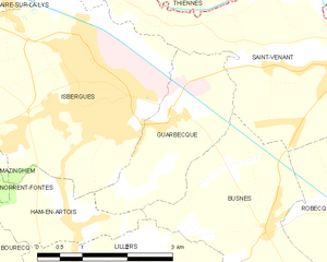
Guarbecque
- commune in Pas-de-Calais, France
- Country:
- Postal Code: 62330
- Coordinates: 50° 36' 39" N, 2° 29' 22" E
- GPS tracks (wikiloc): [Link]
- Area: 5.46 sq km
- Population: 1443
- Web site: [Link]


Ham-en-Artois
- commune in Pas-de-Calais, France
- Country:
- Postal Code: 62190
- Coordinates: 50° 35' 20" N, 2° 27' 29" E
- GPS tracks (wikiloc): [Link]
- Area: 3.2 sq km
- Population: 1015
- Web site: [Link]

Gonnehem
- commune in Pas-de-Calais, France
- Country:
- Postal Code: 62920
- Coordinates: 50° 33' 42" N, 2° 34' 26" E
- GPS tracks (wikiloc): [Link]
- Area: 15.31 sq km
- Population: 2559