Cagnano Varano (Cagnano Varano)
.svg)
- Italian comune
 Hiking in Cagnano Varano
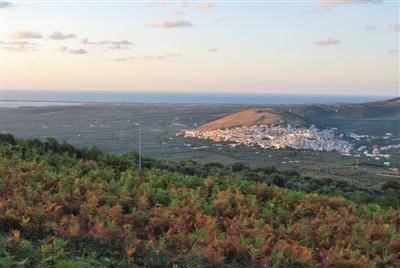
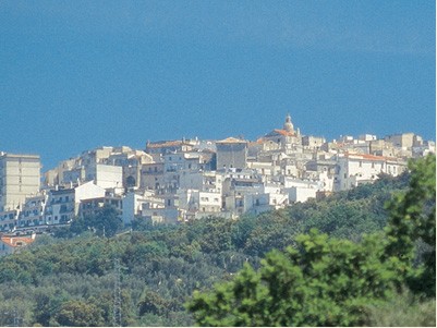
Cagnano Varano is a picturesque town located in the province of Foggia, in the Apulia region of Italy. Nestled near the Gargano National Park, this area offers excellent opportunities for hiking enthusiasts, with stunning landscapes that include coastal views, forests, and the unique karst formations typical of the region.
Hiking Paths and Trails
-
Gargano National Park Trails: The park surrounding Cagnano Varano boasts numerous hiking trails that cater to different skill levels. Trails vary in length and difficulty, allowing for both leisurely walks and more challenging hikes.
-
Foresta Umbra: An essential part of the Gargano National Park, this ancient forest is filled with beech trees, oaks, and diverse wildlife. Hiking here allows you to immerse yourself in nature while enjoying shaded trails and the sounds of birds and other creatures.
-
Coastal Routes: The proximity to the Adriatic Sea means there are also beautiful coastal hiking routes. These paths offer breathtaking views of the sea and beaches, perfect for capturing the sunset or enjoying a picnic with a view.
Flora and Fauna
Cagnano Varano and its surroundings are rich in biodiversity. While hiking, you can expect to see various plant species, from wildflowers in the spring to the dense foliage of the forests. Birdwatching is also popular here, as the area is home to various bird species.
Tips for Hiking in Cagnano Varano
-
Best Time to Visit: Spring (April to June) and early autumn (September to October) are ideal for hiking, as the weather is mild and the landscapes are vibrant with flora.
-
Prepare for Varying Terrain: The trails can vary significantly, so wear appropriate footwear and bring plenty of water, especially during the warmer months.
-
Local Guidance: Consider hiring a local guide for a deeper understanding of the area's ecology and history, as well as to ensure safety while exploring more challenging routes.
-
Respect Nature: Follow the Leave No Trace principles. Make sure to take your litter with you and stick to marked trails to protect the local environment.
Local Attractions
After a day of hiking, Cagnano Varano offers charming local eateries where you can try regional cuisine, including fresh seafood and traditional Apulian dishes. Don't forget to explore the town itself, which has a rich history and beautiful architecture.
Overall, hiking in Cagnano Varano provides a fantastic opportunity to experience Italy's natural beauty, with diverse landscapes and a tranquil atmosphere. Enjoy your outdoor adventures!
- Country:

- Postal Code: 71010
- Local Dialing Code: 0884
- Licence Plate Code: FG
- Coordinates: 41° 50' 0" N, 15° 46' 0" E


- GPS tracks (wikiloc): [Link]
- AboveSeaLevel: 175 м m
- Area: 166.84 sq km
- Population: 7194
- Web site: http://www.comune.cagnanovarano.fg.it
- Wikipedia en: wiki(en)
- Wikipedia: wiki(it)
- Wikidata storage: Wikidata: Q51896
- Wikipedia Commons Category: [Link]
- Freebase ID: [/m/0fygb6]
- GeoNames ID: Alt: [6541935]
- VIAF ID: Alt: [234815148]
- OSM relation ID: [41550]
- WOEID: [711668]
- ISTAT ID: 071008
- Italian cadastre code: B357
Shares border with regions:

Carpino
- Italian comune
Hiking in Carpino
Carpino, a charming town located in the Apulia region of Italy, offers a variety of hiking opportunities that cater to outdoor enthusiasts. The surrounding landscape features beautiful Mediterranean flora, rolling hills, and scenic views of the Adriatic Sea, making it an ideal location for hikers....
- Country:
- Postal Code: 71010
- Local Dialing Code: 0884
- Licence Plate Code: FG
- Coordinates: 41° 45' 0" N, 15° 50' 30" E
- GPS tracks (wikiloc): [Link]
- AboveSeaLevel: 147 м m
- Area: 80.05 sq km
- Population: 4101
- Web site: [Link]

Ischitella
- Italian comune
Hiking in Ischitella
Ischitella is a charming town located in the Apulia region of Italy, known for its stunning landscapes, historical sites, and proximity to beautiful coastal areas. Though it may not be as widely recognized as some other hiking destinations, it offers several opportunities for outdoor enthusiasts and nature lovers. Here are a few details to consider when hiking in and around Ischitella:...
- Country:
- Postal Code: 71010
- Local Dialing Code: 0884
- Licence Plate Code: FG
- Coordinates: 41° 54' 16" N, 15° 53' 58" E
- GPS tracks (wikiloc): [Link]
- AboveSeaLevel: 310 м m
- Area: 85.46 sq km
- Population: 4411
- Web site: [Link]

Monte Sant'Angelo
- Italian comune
Hiking in Monte Sant'Angelo
Monte Sant'Angelo is a scenic town located in the Apulia region of southern Italy, situated on the Gargano Peninsula. It offers a variety of hiking opportunities, characterized by stunning landscapes, rich historical sites, and diverse flora and fauna....
- Country:
- Postal Code: 71037
- Local Dialing Code: 0884
- Licence Plate Code: FG
- Coordinates: 41° 42' 0" N, 15° 58' 0" E
- GPS tracks (wikiloc): [Link]
- AboveSeaLevel: 796 м m
- Area: 245.13 sq km
- Population: 12342
- Web site: [Link]


San Marco in Lamis
- Italian comune
Hiking in San Marco in Lamis
San Marco in Lamis, located in the Apulia region of Italy, offers a variety of hiking opportunities amidst beautiful natural landscapes and historical sites. Here are some key points about hiking in this area:...
- Country:
- Postal Code: 71014
- Local Dialing Code: 0882
- Licence Plate Code: FG
- Coordinates: 41° 42' 42" N, 15° 38' 6" E
- GPS tracks (wikiloc): [Link]
- AboveSeaLevel: 550 м m
- Area: 234.2 sq km
- Population: 13583
- Web site: [Link]

San Nicandro Garganico
- Italian comune
Hiking in San Nicandro Garganico
San Nicandro Garganico, located in the Apulia region of southern Italy, is a charming town situated on the Gargano Promontory. This area is known for its stunning natural landscapes, rich biodiversity, and various outdoor activities, making it a fantastic destination for hiking enthusiasts. Here are some key points to consider for hiking in and around San Nicandro Garganico:...
- Country:
- Postal Code: 71015
- Local Dialing Code: 0882
- Licence Plate Code: FG
- Coordinates: 41° 50' 0" N, 15° 34' 0" E
- GPS tracks (wikiloc): [Link]
- AboveSeaLevel: 224 м m
- Area: 173.36 sq km
- Population: 15224
- Web site: [Link]