
Cahors (Cahors)


- commune in Lot, France
- Country:

- Postal Code: 46000
- Coordinates: 44° 26' 51" N, 1° 26' 26" E


- GPS tracks (wikiloc): [Link]
- AboveSeaLevel: 130 м m
- Area: 64.72 sq km
- Population: 19340
- Web site: http://www.mairie-cahors.fr
- Wikipedia en: wiki(en)
- Wikipedia: wiki(fr)
- Wikidata storage: Wikidata: Q23047
- Wikipedia Commons Gallery: [Link]
- Wikipedia Commons Category: [Link]
- Freebase ID: [/m/030dtv]
- Freebase ID: [/m/030dtv]
- Freebase ID: [/m/030dtv]
- GeoNames ID: Alt: [3029213]
- GeoNames ID: Alt: [3029213]
- GeoNames ID: Alt: [3029213]
- SIREN number: [214600421]
- SIREN number: [214600421]
- SIREN number: [214600421]
- BnF ID: [15260783w]
- BnF ID: [15260783w]
- BnF ID: [15260783w]
- VIAF ID: Alt: [126679060]
- VIAF ID: Alt: [126679060]
- VIAF ID: Alt: [126679060]
- OSM relation ID: [122324]
- OSM relation ID: [122324]
- OSM relation ID: [122324]
- GND ID: Alt: [4009297-5]
- GND ID: Alt: [4009297-5]
- GND ID: Alt: [4009297-5]
- archINFORM location ID: [7414]
- archINFORM location ID: [7414]
- archINFORM location ID: [7414]
- Library of Congress authority ID: Alt: [n81071971]
- Library of Congress authority ID: Alt: [n81071971]
- Library of Congress authority ID: Alt: [n81071971]
- MusicBrainz area ID: [817de950-b8cb-41fc-a337-ceae6f2b507f]
- MusicBrainz area ID: [817de950-b8cb-41fc-a337-ceae6f2b507f]
- MusicBrainz area ID: [817de950-b8cb-41fc-a337-ceae6f2b507f]
- Quora topic ID: [Cahors]
- Quora topic ID: [Cahors]
- Quora topic ID: [Cahors]
- SUDOC authorities ID: [183567277]
- SUDOC authorities ID: [183567277]
- SUDOC authorities ID: [183567277]
- Encyclopædia Britannica Online ID: [place/Cahors]
- Encyclopædia Britannica Online ID: [place/Cahors]
- Encyclopædia Britannica Online ID: [place/Cahors]
- Gran Enciclopèdia Catalana ID: [0014567]
- Gran Enciclopèdia Catalana ID: [0014567]
- Gran Enciclopèdia Catalana ID: [0014567]
- Encyclopædia Universalis ID: [cahors]
- Encyclopædia Universalis ID: [cahors]
- Encyclopædia Universalis ID: [cahors]
- Great Russian Encyclopedia Online ID: [2042708]
- Great Russian Encyclopedia Online ID: [2042708]
- Great Russian Encyclopedia Online ID: [2042708]
- Digital Atlas of the Roman Empire ID: [150]
- Digital Atlas of the Roman Empire ID: [150]
- Digital Atlas of the Roman Empire ID: [150]
- INSEE municipality code: 46042
- INSEE municipality code: 46042
- INSEE municipality code: 46042
Shares border with regions:


Arcambal
- commune in Lot, France
- Country:
- Postal Code: 46090
- Coordinates: 44° 27' 23" N, 1° 30' 51" E
- GPS tracks (wikiloc): [Link]
- Area: 23.11 sq km
- Population: 999
Calamane
- commune in Lot, France
- Country:
- Postal Code: 46150
- Coordinates: 44° 31' 33" N, 1° 23' 27" E
- GPS tracks (wikiloc): [Link]
- Area: 7.6 sq km
- Population: 458


Laroque-des-Arcs
- former commune in Lot, France
- Country:
- Postal Code: 46090
- Coordinates: 44° 28' 33" N, 1° 28' 4" E
- GPS tracks (wikiloc): [Link]
- Area: 7.69 sq km
- Population: 507

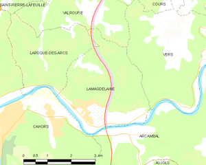
Lamagdelaine
- commune in Lot, France
- Country:
- Postal Code: 46090
- Coordinates: 44° 28' 3" N, 1° 29' 22" E
- GPS tracks (wikiloc): [Link]
- Area: 10.58 sq km
- Population: 715


Pradines
- commune in Lot, France
- Country:
- Postal Code: 46090
- Coordinates: 44° 28' 44" N, 1° 24' 15" E
- GPS tracks (wikiloc): [Link]
- Area: 16.49 sq km
- Population: 3424
- Web site: [Link]


Mercuès
- commune in Lot, France
- Country:
- Postal Code: 46090
- Coordinates: 44° 29' 50" N, 1° 23' 8" E
- GPS tracks (wikiloc): [Link]
- Area: 7.24 sq km
- Population: 1055
Flaujac-Poujols
- commune in Lot, France
- Country:
- Postal Code: 46090
- Coordinates: 44° 24' 21" N, 1° 29' 58" E
- GPS tracks (wikiloc): [Link]
- Area: 12.64 sq km
- Population: 732


Le Montat
- commune in Lot, France
- Country:
- Postal Code: 46090
- Coordinates: 44° 22' 48" N, 1° 26' 56" E
- GPS tracks (wikiloc): [Link]
- Area: 22.54 sq km
- Population: 1044


Labastide-Marnhac
- commune in Lot, France
- Country:
- Postal Code: 46090
- Coordinates: 44° 23' 19" N, 1° 23' 59" E
- GPS tracks (wikiloc): [Link]
- Area: 28.87 sq km
- Population: 1215

Saint-Pierre-Lafeuille
- commune in Lot, France
- Country:
- Postal Code: 46090
- Coordinates: 44° 31' 25" N, 1° 27' 14" E
- GPS tracks (wikiloc): [Link]
- Area: 8.52 sq km
- Population: 370
Trespoux-Rassiels
- commune in Lot, France
- Country:
- Postal Code: 46090
- Coordinates: 44° 24' 50" N, 1° 22' 14" E
- GPS tracks (wikiloc): [Link]
- Area: 20.7 sq km
- Population: 809