Laroque-des-Arcs (Laroque-des-Arcs)

- former commune in Lot, France
- Country:

- Postal Code: 46090
- Coordinates: 44° 28' 33" N, 1° 28' 4" E


- GPS tracks (wikiloc): [Link]
- Area: 7.69 sq km
- Population: 507
- Wikipedia en: wiki(en)
- Wikipedia: wiki(fr)
- Wikidata storage: Wikidata: Q1112872
- Wikipedia Commons Category: [Link]
- Freebase ID: [/m/03nwnj6]
- GeoNames ID: Alt: [6434812]
- BnF ID: [15260897v]
- WOEID: [12664507]
- INSEE municipality code: 46156
Shares border with regions:

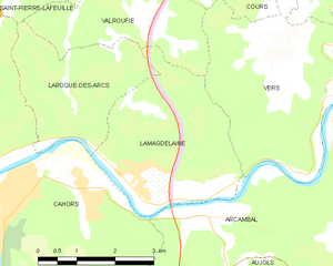
Lamagdelaine
- commune in Lot, France
- Country:
- Postal Code: 46090
- Coordinates: 44° 28' 3" N, 1° 29' 22" E
- GPS tracks (wikiloc): [Link]
- Area: 10.58 sq km
- Population: 715
Valroufié
- former commune in Lot, France
- Country:
- Postal Code: 46090
- Coordinates: 44° 31' 8" N, 1° 29' 16" E
- GPS tracks (wikiloc): [Link]
- Area: 13.48 sq km
- Population: 440


Cahors
- commune in Lot, France
- Country:
- Postal Code: 46000
- Coordinates: 44° 26' 51" N, 1° 26' 26" E
- GPS tracks (wikiloc): [Link]
- AboveSeaLevel: 130 м m
- Area: 64.72 sq km
- Population: 19340
- Web site: [Link]

Saint-Pierre-Lafeuille
- commune in Lot, France
- Country:
- Postal Code: 46090
- Coordinates: 44° 31' 25" N, 1° 27' 14" E
- GPS tracks (wikiloc): [Link]
- Area: 8.52 sq km
- Population: 370