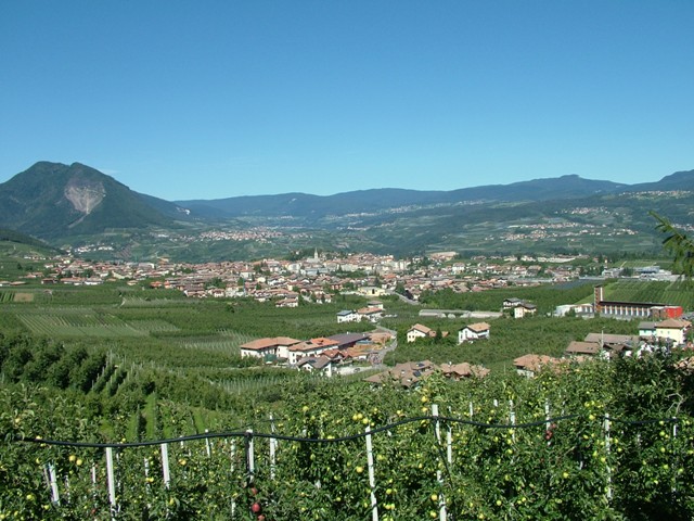
Caldes (Caldes)
%202018.svg)
- Italian comune
 Hiking in Caldes
Caldes, a picturesque area in northern Italy, particularly known for its thermal springs, offers a variety of hiking opportunities that cater to different skill levels. Situated near the stunning Dolomites and surrounded by beautiful landscapes, hiking in Caldes allows you to experience both natural beauty and cultural heritage.
Key Hiking Trails in Caldes:
-
Sentiero del Sole (Sun Trail): This is one of the most popular trails in the area. It takes you through scenic views of the Val di Non, with paths that weave through apple orchards, forests, and meadows. The trail is suitable for families and beginner hikers.
-
Val di Non Loop: This loop offers a mix of terrain and landscapes, allowing hikers to experience the unique flora and fauna of the region. The route provides breathtaking views of the surrounding mountains and valleys.
-
Piz Galin: For more experienced hikers, the trail to Piz Galin presents a challenging ascent with rewarding panoramic views of the Dolomites and the nearby lakes. This trail requires good physical fitness and navigation skills.
-
Cascate di Nardis: A beautiful hike that leads to the stunning Nardis Waterfalls. This trail is moderately difficult and showcases the area's natural beauty and the sound of rushing water.
Tips for Hiking in Caldes:
-
Best Time to Hike: The best seasons for hiking in Caldes are late spring through early autumn (May to October), when trails are more accessible, and the weather is generally favorable.
-
Weather Considerations: Be sure to check local weather conditions before heading out, as temperatures can vary greatly in the mountains.
-
Equipment: Proper hiking boots with good traction, weather-appropriate clothing, and a daypack with water and snacks are essential for an enjoyable hike.
-
Maps and Guidance: If you’re not familiar with the area, consider obtaining maps or hiring a local guide. The trails are generally well-marked, but having detailed navigation can enhance your experience.
-
Respect Nature: Practice Leave No Trace principles to protect the environment, stay on marked paths, and take your trash with you.
Local Attractions:
After hiking, you can relax in the thermal baths in Caldes, which offer a variety of wellness treatments. Exploring the local culture, including traditional cuisine and historical sites, can further enhance your visit.
Whether you're a seasoned hiker or a novice looking to enjoy nature, Caldes has a range of trails and stunning scenery to explore!
- Country:

- Postal Code: 38022
- Local Dialing Code: 0463
- Licence Plate Code: TN
- Coordinates: 46° 22' 0" N, 10° 57' 0" E


- GPS tracks (wikiloc): [Link]
- AboveSeaLevel: 697 м m
- Area: 20.81 sq km
- Population: 1089
- Web site: http://www.comune.caldes.tn.it
- Wikipedia en: wiki(en)
- Wikipedia: wiki(it)
- Wikidata storage: Wikidata: Q257221
- Wikipedia Commons Category: [Link]
- Freebase ID: [/m/0g9y69]
- GeoNames ID: Alt: [6536230]
- VIAF ID: Alt: [247402426]
- OSM relation ID: [47144]
- ISTAT ID: 022033
- Italian cadastre code: B400
Shares border with regions:
Bresimo
- Italian comune
Hiking in Bresimo
Bresimo, located in the Province of Trento in Northern Italy, is a hidden gem for hiking enthusiasts. Nestled in the Val di Non region, it offers stunning landscapes, diverse trails, and a deep connection with nature....
- Country:
- Postal Code: 38020
- Local Dialing Code: 0463
- Licence Plate Code: TN
- Coordinates: 46° 25' 0" N, 10° 58' 0" E
- GPS tracks (wikiloc): [Link]
- AboveSeaLevel: 900 м m
- Area: 41.01 sq km
- Population: 249
- Web site: [Link]
Cavizzana
- Italian comune
Hiking in Cavizzana
Cavizzana is a charming village located in the Trentino region of northern Italy, nestled in the beautiful Val di Sole, which is known for its stunning natural landscapes and outdoor recreational opportunities. Hiking in and around Cavizzana offers a mix of scenic views, varied terrain, and the chance to experience the rich flora and fauna of the area....
- Country:
- Postal Code: 38022
- Local Dialing Code: 0463
- Licence Plate Code: TN
- Coordinates: 46° 22' 3" N, 10° 57' 29" E
- GPS tracks (wikiloc): [Link]
- AboveSeaLevel: 710 м m
- Area: 3.38 sq km
- Population: 242
- Web site: [Link]


Cis, Trentino
- Italian comune
Hiking in Cis, Trentino
Cis is a charming village located in the Trentino region of northern Italy, nestled in the scenic Val di Non. It's an ideal location for hiking, offering stunning landscapes, diverse flora and fauna, and a glimpse into the rich cultural heritage of the area. Here are some highlights for hiking in and around Cis:...
- Country:
- Postal Code: 38020
- Local Dialing Code: 0463
- Licence Plate Code: TN
- Coordinates: 46° 23' 59" N, 11° 0' 6" E
- GPS tracks (wikiloc): [Link]
- AboveSeaLevel: 732 м m
- Area: 5.5 sq km
- Population: 302
- Web site: [Link]

Cles
- Italian comune
Hiking in Cles
Cles, located in the Trentino region of northern Italy, is a beautiful destination for hiking enthusiasts. Nestled in the Val di Non, it offers a variety of trails that cater to different skill levels, from easy walks to more challenging hikes. Here are some highlights of hiking in and around Cles:...
- Country:
- Postal Code: 38023
- Local Dialing Code: 0463
- Licence Plate Code: TN
- Coordinates: 46° 22' 0" N, 11° 2' 0" E
- GPS tracks (wikiloc): [Link]
- AboveSeaLevel: 656 м m
- Area: 39.17 sq km
- Population: 7009
- Web site: [Link]


Malé
- Italian comune
Hiking in Malé
Malé, located in the Val di Sole region of Trentino, Italy, is a charming town that serves as a gateway to various hiking opportunities in the surrounding mountains. The area is known for its stunning landscapes, rich flora and fauna, and a mix of trails suitable for different skill levels, making it a popular destination for hikers....
- Country:
- Postal Code: 38027
- Local Dialing Code: 0463
- Licence Plate Code: TN
- Coordinates: 46° 21' 13" N, 10° 54' 45" E
- GPS tracks (wikiloc): [Link]
- AboveSeaLevel: 737 м m
- Area: 26.53 sq km
- Population: 2145
- Web site: [Link]


Terzolas
- Italian comune
Hiking in Terzolas
Terzolas is a charming village located in the Trentino region of northern Italy, surrounded by beautiful landscapes and offering a variety of hiking opportunities. Situated near the Val di Non, Terzolas provides access to several trails that cater to different skill levels....
- Country:
- Postal Code: 38027
- Local Dialing Code: 0463
- Licence Plate Code: TN
- Coordinates: 46° 21' 41" N, 10° 55' 34" E
- GPS tracks (wikiloc): [Link]
- AboveSeaLevel: 755 м m
- Area: 5.59 sq km
- Population: 638
- Web site: [Link]