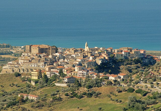
Caloveto (Caloveto)
.svg)
- Italian comune
 Hiking in Caloveto
Caloveto is a charming town located in the Calabria region of southern Italy. It offers beautiful landscapes and a rich natural environment which makes it a great place for hiking enthusiasts. Here are some highlights of hiking in and around Caloveto:
-
Scenic Trails: The area around Caloveto features various trails that take you through stunning landscapes, including coastal views, rolling hills, and rugged terrain. The proximity to the Tyrrhenian Sea means you can enjoy hikes with spectacular sea views.
-
Natural Parks: The nearby Sila National Park and Aspromonte National Park provide extensive hiking opportunities. You can explore diverse ecosystems, unique flora and fauna, and dramatic mountain scenery.
-
Cultural Insights: Hiking in Caloveto not only immerses you in nature but also allows you to discover cultural and historical landmarks such as old monasteries and traditional stone villages along the way.
-
Local Coasts: The coastline near Caloveto offers unique hiking experiences with trails that lead to secluded beaches and rocky cliffs. These trails can be combined with swimming or relaxation time on the beach.
-
Seasonal Considerations: The best time for hiking in Caloveto tends to be in the spring and fall when temperatures are more moderate. Summer can be hot, while winter might bring some snowfall in higher elevations.
-
Wildlife: Keep an eye out for local wildlife, including various bird species, deer, and other indigenous animals. The biodiversity in this region is quite rich.
Before you head out, it's important to research and choose trails that match your skill level and to check local maps and guides for safety and terrain details. Always carry plenty of water and appropriate gear, as well as local advice on trail conditions. Happy hiking!
- Country:

- Postal Code: 87060
- Local Dialing Code: 0983
- Licence Plate Code: CS
- Coordinates: 39° 30' 0" N, 16° 46' 0" E


- GPS tracks (wikiloc): [Link]
- AboveSeaLevel: 385 м m
- Area: 24.96 sq km
- Population: 1215
- Web site: http://www.comune.caloveto.cs.it
- Wikipedia en: wiki(en)
- Wikipedia: wiki(it)
- Wikidata storage: Wikidata: Q53847
- Wikipedia Commons Category: [Link]
- Freebase ID: [/m/0f_n3n]
- GeoNames ID: Alt: [6541284]
- OSM relation ID: [39955]
- ISTAT ID: 078022
- Italian cadastre code: B426
Shares border with regions:

Calopezzati
- Italian comune
Hiking in Calopezzati
Calopezzati is a charming town located in the Calabria region of southern Italy. While it may not be as widely recognized as some of the more popular hiking destinations, it offers beautiful landscapes and a rich cultural experience for those who venture into its surrounding areas....
- Country:
- Postal Code: 87060
- Local Dialing Code: 0983
- Licence Plate Code: CS
- Coordinates: 39° 34' 0" N, 16° 48' 0" E
- GPS tracks (wikiloc): [Link]
- AboveSeaLevel: 217 м m
- Area: 22.57 sq km
- Population: 1361
- Web site: [Link]
Cropalati
- Italian comune
Hiking in Cropalati
Cropalati is a small municipality in the Calabria region of southern Italy, located in the province of Cosenza. This area is known for its stunning natural landscapes, which can provide some unique hiking opportunities. While Cropalati itself may not be as widely recognized as a hiking destination as other parts of Calabria, it serves as a great starting point for exploring the surrounding areas....
- Country:
- Postal Code: 87060
- Local Dialing Code: 0983
- Licence Plate Code: CS
- Coordinates: 39° 31' 0" N, 16° 43' 36" E
- GPS tracks (wikiloc): [Link]
- AboveSeaLevel: 384 м m
- Area: 33.7 sq km
- Population: 1064
- Web site: [Link]


Longobucco
- Italian comune
Hiking in Longobucco
Longobucco, located in the Calabria region of southern Italy, offers a unique hiking experience with its stunning natural landscapes, rich biodiversity, and cultural heritage. The area is characterized by its mountainous terrain, lush forests, and picturesque views, making it an appealing destination for outdoor enthusiasts....
- Country:
- Postal Code: 87066
- Local Dialing Code: 0983
- Licence Plate Code: CS
- Coordinates: 39° 27' 0" N, 16° 37' 0" E
- GPS tracks (wikiloc): [Link]
- AboveSeaLevel: 800 м m
- Area: 212.26 sq km
- Population: 3008
- Web site: [Link]
Pietrapaola
- Italian comune
Hiking in Pietrapaola
Pietrapaola, a charming village in Calabria, Italy, is surrounded by beautiful landscapes that make it an appealing destination for hiking enthusiasts. Nestled near the Tyrrhenian Sea and the rugged mountains, the area offers a variety of trails with stunning views, diverse flora and fauna, and cultural sites....
- Country:
- Postal Code: 87060
- Local Dialing Code: 0983
- Licence Plate Code: CS
- Coordinates: 39° 29' 0" N, 16° 49' 0" E
- GPS tracks (wikiloc): [Link]
- AboveSeaLevel: 50 м m
- Area: 52.82 sq km
- Population: 1109
- Web site: [Link]