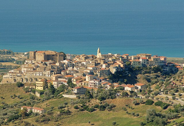
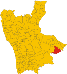
Pietrapaola (Pietrapaola)
.svg)
- Italian comune
 Hiking in Pietrapaola
Pietrapaola, a charming village in Calabria, Italy, is surrounded by beautiful landscapes that make it an appealing destination for hiking enthusiasts. Nestled near the Tyrrhenian Sea and the rugged mountains, the area offers a variety of trails with stunning views, diverse flora and fauna, and cultural sites.
Hiking Trails
-
Coastal Trails: The proximity to the coastline allows for picturesque hikes along the Mediterranean Sea. Coastal paths often provide breathtaking views of the sea and opportunities to explore hidden beaches and coves.
-
Mountain Trails: The Aspromonte National Park and nearby mountainous regions offer challenging hikes through rugged terrain, featuring waterfalls, steep inclines, and panoramic views from the mountain tops.
-
Cultural Routes: Some trails lead through historical sites, ancient ruins, and charming villages, allowing hikers to experience the rich cultural heritage of the region. These paths can often be combined with visits to local attractions, such as churches and local eateries.
Best Times to Hike
- Spring (March to June): With mild temperatures and blooming flora, spring is a fantastic time to hike in the area. The pleasant weather makes the trails more accessible and enjoyable.
- Fall (September to November): Similar to spring, fall offers comfortable weather and beautiful autumn colors, enhancing the landscape.
Important Considerations
- Preparation: Always check trail conditions before heading out, as some trails may be affected by weather or maintenance work.
- Safety: Wear appropriate hiking gear, bring enough water and snacks, and let someone know your plans. Cellular service may be limited in remote areas.
- Guided Tours: If you're unfamiliar with the terrain, consider joining a guided hiking tour to learn about the local ecology and history while ensuring safety.
Hiking in Pietrapaola provides an excellent opportunity to explore the natural beauty and cultural richness of Calabria, making it a memorable experience for hikers of all levels.
- Country:

- Postal Code: 87060
- Local Dialing Code: 0983
- Licence Plate Code: CS
- Coordinates: 39° 29' 0" N, 16° 49' 0" E


- GPS tracks (wikiloc): [Link]
- AboveSeaLevel: 50 м m
- Area: 52.82 sq km
- Population: 1109
- Web site: http://www.comunepietrapaola.it
- Wikipedia en: wiki(en)
- Wikipedia: wiki(it)
- Wikidata storage: Wikidata: Q53936
- Wikipedia Commons Category: [Link]
- Freebase ID: [/m/0f_nlk]
- GeoNames ID: Alt: [6537680]
- VIAF ID: Alt: [313476459]
- OSM relation ID: [39941]
- TGN ID: [1045994]
- Digital Atlas of the Roman Empire ID: [30450]
- ISTAT ID: 078099
- Italian cadastre code: G622
Shares border with regions:


Bocchigliero
- Italian comune
Hiking in Bocchigliero
Bocchigliero is a charming village located in the Calabria region of southern Italy, nestled in the Sila National Park area. Known for its picturesque landscapes, Bocchigliero offers several opportunities for hiking enthusiasts to explore the natural beauty of the region....
- Country:
- Postal Code: 87060
- Local Dialing Code: 0983
- Licence Plate Code: CS
- Coordinates: 39° 25' 0" N, 16° 45' 0" E
- GPS tracks (wikiloc): [Link]
- AboveSeaLevel: 1100 м m
- Area: 98.82 sq km
- Population: 1250
- Web site: [Link]

Calopezzati
- Italian comune
Hiking in Calopezzati
Calopezzati is a charming town located in the Calabria region of southern Italy. While it may not be as widely recognized as some of the more popular hiking destinations, it offers beautiful landscapes and a rich cultural experience for those who venture into its surrounding areas....
- Country:
- Postal Code: 87060
- Local Dialing Code: 0983
- Licence Plate Code: CS
- Coordinates: 39° 34' 0" N, 16° 48' 0" E
- GPS tracks (wikiloc): [Link]
- AboveSeaLevel: 217 м m
- Area: 22.57 sq km
- Population: 1361
- Web site: [Link]
Caloveto
- Italian comune
Hiking in Caloveto
Caloveto is a charming town located in the Calabria region of southern Italy. It offers beautiful landscapes and a rich natural environment which makes it a great place for hiking enthusiasts. Here are some highlights of hiking in and around Caloveto:...
- Country:
- Postal Code: 87060
- Local Dialing Code: 0983
- Licence Plate Code: CS
- Coordinates: 39° 30' 0" N, 16° 46' 0" E
- GPS tracks (wikiloc): [Link]
- AboveSeaLevel: 385 м m
- Area: 24.96 sq km
- Population: 1215
- Web site: [Link]

Campana
- Italian comune
Hiking in Campana
Campana, located in the Calabria region of southern Italy, offers a range of beautiful landscapes and hiking opportunities for outdoor enthusiasts. The area is characterized by its stunning mountainous terrain, lush greenery, and picturesque views of the surrounding countryside. Here’s an overview of what you can expect when hiking in and around Campana:...
- Country:
- Postal Code: 87061
- Local Dialing Code: 0983
- Licence Plate Code: CS
- Coordinates: 39° 25' 0" N, 16° 49' 0" E
- GPS tracks (wikiloc): [Link]
- AboveSeaLevel: 617 м m
- Area: 104.65 sq km
- Population: 1723
- Web site: [Link]


Longobucco
- Italian comune
Hiking in Longobucco
Longobucco, located in the Calabria region of southern Italy, offers a unique hiking experience with its stunning natural landscapes, rich biodiversity, and cultural heritage. The area is characterized by its mountainous terrain, lush forests, and picturesque views, making it an appealing destination for outdoor enthusiasts....
- Country:
- Postal Code: 87066
- Local Dialing Code: 0983
- Licence Plate Code: CS
- Coordinates: 39° 27' 0" N, 16° 37' 0" E
- GPS tracks (wikiloc): [Link]
- AboveSeaLevel: 800 м m
- Area: 212.26 sq km
- Population: 3008
- Web site: [Link]
Mandatoriccio
- Italian comune
Hiking in Mandatoriccio
Mandatoriccio is a charming village located in Calabria, Italy, known for its natural beauty and picturesque landscapes. While it might not be one of the most famous hiking destinations, it offers several opportunities for outdoor enthusiasts to explore its scenic trails and enjoy the coastal views....
- Country:
- Postal Code: 87060
- Local Dialing Code: 0983
- Licence Plate Code: CS
- Coordinates: 39° 28' 0" N, 16° 50' 0" E
- GPS tracks (wikiloc): [Link]
- AboveSeaLevel: 561 м m
- Area: 37.32 sq km
- Population: 2765
- Web site: [Link]