Camembert (Camembert)

- commune in canton of Vimoutiers, department of Orne, Normandy, France
- Country:

- Postal Code: 61120
- Coordinates: 48° 53' 35" N, 0° 10' 39" E


- GPS tracks (wikiloc): [Link]
- Area: 10.3 sq km
- Population: 187
- Web site: http://www.camembert.eu
- Wikipedia en: wiki(en)
- Wikipedia: wiki(fr)
- Wikidata storage: Wikidata: Q217077
- Wikipedia Commons Category: [Link]
- Freebase ID: [/m/02dg3s]
- Freebase ID: [/m/02dg3s]
- GeoNames ID: Alt: [6450208]
- GeoNames ID: Alt: [6450208]
- SIREN number: [216100719]
- SIREN number: [216100719]
- BnF ID: [15268006f]
- BnF ID: [15268006f]
- INSEE municipality code: 61071
- INSEE municipality code: 61071
Shares border with regions:


Champosoult
- commune in Orne, France
- Country:
- Postal Code: 61120
- Coordinates: 48° 51' 58" N, 0° 10' 58" E
- GPS tracks (wikiloc): [Link]
- Area: 7.01 sq km
- Population: 96


Crouttes
- commune in Orne, France
- Country:
- Postal Code: 61120
- Coordinates: 48° 55' 25" N, 0° 8' 19" E
- GPS tracks (wikiloc): [Link]
- Area: 13.47 sq km
- Population: 315

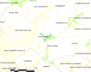
Coudehard
- commune in Orne, France
- Country:
- Postal Code: 61160
- Coordinates: 48° 50' 37" N, 0° 8' 5" E
- GPS tracks (wikiloc): [Link]
- Area: 8.52 sq km
- Population: 83
Guerquesalles
- commune in Orne, France
- Country:
- Postal Code: 61120
- Coordinates: 48° 54' 23" N, 0° 12' 26" E
- GPS tracks (wikiloc): [Link]
- Area: 8.66 sq km
- Population: 133
Fresnay-le-Samson
- commune in Orne, France
- Country:
- Postal Code: 61120
- Coordinates: 48° 53' 0" N, 0° 12' 34" E
- GPS tracks (wikiloc): [Link]
- Area: 6.76 sq km
- Population: 97


Les Champeaux
- commune in Orne, France
- Country:
- Postal Code: 61120
- Coordinates: 48° 53' 35" N, 0° 7' 58" E
- GPS tracks (wikiloc): [Link]
- Area: 9.65 sq km
- Population: 121

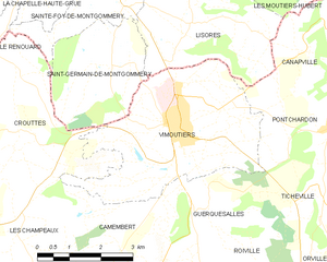
Vimoutiers
- commune in Orne, France
- Country:
- Postal Code: 61120
- Coordinates: 48° 55' 39" N, 0° 11' 52" E
- GPS tracks (wikiloc): [Link]
- AboveSeaLevel: 134 м m
- Area: 16.15 sq km
- Population: 3436
- Web site: [Link]