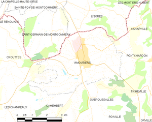
Vimoutiers (Vimoutiers)
- commune in Orne, France
- Country:

- Postal Code: 61120
- Coordinates: 48° 55' 39" N, 0° 11' 52" E


- GPS tracks (wikiloc): [Link]
- AboveSeaLevel: 134 м m
- Area: 16.15 sq km
- Population: 3436
- Web site: http://www.vimoutiers.fr
- Wikipedia en: wiki(en)
- Wikipedia: wiki(fr)
- Wikidata storage: Wikidata: Q729239
- Wikipedia Commons Category: [Link]
- Freebase ID: [/m/06km8m]
- Freebase ID: [/m/06km8m]
- GeoNames ID: Alt: [2968072]
- GeoNames ID: Alt: [2968072]
- SIREN number: [216105080]
- SIREN number: [216105080]
- BnF ID: [15268437t]
- BnF ID: [15268437t]
- VIAF ID: Alt: [237394645]
- VIAF ID: Alt: [237394645]
- WOEID: [632314]
- WOEID: [632314]
- INSEE municipality code: 61508
- INSEE municipality code: 61508
Shares border with regions:


Lisores
- commune in Calvados, France
- Country:

- Postal Code: 14140
- Coordinates: 48° 57' 42" N, 0° 12' 14" E


- GPS tracks (wikiloc): [Link]
- Area: 11.91 sq km
- Population: 271


Crouttes
- commune in Orne, France
- Country:

- Postal Code: 61120
- Coordinates: 48° 55' 25" N, 0° 8' 19" E


- GPS tracks (wikiloc): [Link]
- Area: 13.47 sq km
- Population: 315
Guerquesalles
- commune in Orne, France
- Country:

- Postal Code: 61120
- Coordinates: 48° 54' 23" N, 0° 12' 26" E


- GPS tracks (wikiloc): [Link]
- Area: 8.66 sq km
- Population: 133


Canapville
- commune in Orne, France
- Country:

- Postal Code: 61120
- Coordinates: 48° 56' 49" N, 0° 16' 12" E


- GPS tracks (wikiloc): [Link]
- Area: 8.22 sq km
- Population: 215


Camembert
- commune in canton of Vimoutiers, department of Orne, Normandy, France
- Country:

- Postal Code: 61120
- Coordinates: 48° 53' 35" N, 0° 10' 39" E


- GPS tracks (wikiloc): [Link]
- Area: 10.3 sq km
- Population: 187
- Web site: [Link]


Pontchardon
- commune in Orne, France
- Country:

- Postal Code: 61120
- Coordinates: 48° 55' 45" N, 0° 15' 58" E


- GPS tracks (wikiloc): [Link]
- Area: 4.83 sq km
- Population: 224


Ticheville
- commune in Orne, France
- Country:

- Postal Code: 61120
- Coordinates: 48° 54' 30" N, 0° 15' 53" E


- GPS tracks (wikiloc): [Link]
- Area: 9.93 sq km
- Population: 213
Saint-Germain-de-Montgommery
- former commune in Calvados, France
- Country:

- Postal Code: 14140
- Coordinates: 48° 56' 36" N, 0° 10' 22" E


- GPS tracks (wikiloc): [Link]
- AboveSeaLevel: 174 м m
- Area: 8.13 sq km
- Population: 170
