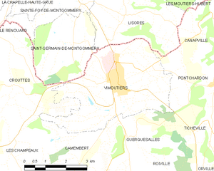
Crouttes (Crouttes)

- commune in Orne, France
- Country:

- Postal Code: 61120
- Coordinates: 48° 55' 25" N, 0° 8' 19" E


- GPS tracks (wikiloc): [Link]
- Area: 13.47 sq km
- Population: 315
- Wikipedia en: wiki(en)
- Wikipedia: wiki(fr)
- Wikidata storage: Wikidata: Q1095057
- Wikipedia Commons Category: [Link]
- Freebase ID: [/m/03qgs5d]
- Freebase ID: [/m/03qgs5d]
- GeoNames ID: Alt: [6439075]
- GeoNames ID: Alt: [6439075]
- SIREN number: [216101394]
- SIREN number: [216101394]
- BnF ID: [15268071w]
- BnF ID: [15268071w]
- VIAF ID: Alt: [242211285]
- VIAF ID: Alt: [242211285]
- INSEE municipality code: 61139
- INSEE municipality code: 61139
Shares border with regions:


Camembert
- commune in canton of Vimoutiers, department of Orne, Normandy, France
- Country:
- Postal Code: 61120
- Coordinates: 48° 53' 35" N, 0° 10' 39" E
- GPS tracks (wikiloc): [Link]
- Area: 10.3 sq km
- Population: 187
- Web site: [Link]
Saint-Germain-de-Montgommery
- former commune in Calvados, France
- Country:
- Postal Code: 14140
- Coordinates: 48° 56' 36" N, 0° 10' 22" E
- GPS tracks (wikiloc): [Link]
- AboveSeaLevel: 174 м m
- Area: 8.13 sq km
- Population: 170


Sainte-Foy-de-Montgommery
- former commune in Calvados, France
- Country:
- Postal Code: 14140
- Coordinates: 48° 57' 38" N, 0° 10' 31" E
- GPS tracks (wikiloc): [Link]
- Area: 4.59 sq km
- Population: 184


Les Champeaux
- commune in Orne, France
- Country:
- Postal Code: 61120
- Coordinates: 48° 53' 35" N, 0° 7' 58" E
- GPS tracks (wikiloc): [Link]
- Area: 9.65 sq km
- Population: 121

Vimoutiers
- commune in Orne, France
- Country:
- Postal Code: 61120
- Coordinates: 48° 55' 39" N, 0° 11' 52" E
- GPS tracks (wikiloc): [Link]
- AboveSeaLevel: 134 м m
- Area: 16.15 sq km
- Population: 3436
- Web site: [Link]


Le Renouard
- commune in Orne, France
- Country:
- Postal Code: 61120
- Coordinates: 48° 55' 16" N, 0° 6' 4" E
- GPS tracks (wikiloc): [Link]
- Area: 14.48 sq km
- Population: 193

Les Autels-Saint-Bazile
- former commune in Calvados, France
- Country:
- Postal Code: 14140
- Coordinates: 48° 56' 26" N, 0° 4' 59" E
- GPS tracks (wikiloc): [Link]
- Area: 5.53 sq km
- Population: 50