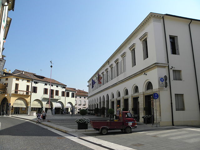
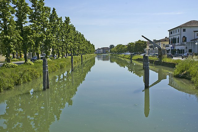
Campagna Lupia (Campagna Lupia)
.svg)
- Italian comune
 Hiking in Campagna Lupia
Campagna Lupia is a charming area located in the province of Venice, Italy. While it's not a large or widely recognized hiking destination, it can offer some pleasant outdoor experiences in the Veneto region. Here are some aspects to consider if you're thinking about hiking in and around Campagna Lupia:
Landscape and Environment
- Rural Setting: Campagna Lupia features picturesque countryside, including fields, wetlands, and waterways. The natural beauty of the area can be quite enjoyable for a leisurely hike.
- Flora and Fauna: Being near the wetlands, hikers can expect to see various plant species and potentially spot local wildlife, particularly birds that thrive in such environments.
Hiking Opportunities
- Local Trails: While specific marked hiking trails might be limited, the countryside around Campagna Lupia can be traversed on foot. You can explore country roads, farm lanes, and paths connecting nearby villages.
- Nearby Nature Parks: Consider venturing slightly further afield to explore more established hiking paths in surrounding natural parks, such as the Regional Park of the Sile River and the Veneto Regional Park.
Preparation Tips
- Weather: The Veneto region can have variable weather, so check forecasts and dress in layers. Spring and early autumn are generally the best times for hiking.
- Footwear: Good hiking boots or sturdy walking shoes are essential, especially if your path takes you through uneven terrain or wet areas.
- Hydration and Snacks: Always bring enough water and some snacks, as options may be sparse in more rural areas.
Cultural Aspects
- Local Villages: Hiking can also be an opportunity to experience local culture. Stop by small hamlets or engage with locals to learn more about the region.
- Culinary Delights: After a hike, you may enjoy local Venetian cuisine in nearby towns. Sampling regional dishes could be a rewarding way to end your hiking adventure.
Conclusion
While Campagna Lupia may not be known for extensive hiking trails, it offers a peaceful setting for leisurely walks amidst nature. For a more robust hiking experience, exploring the wider Veneto region or nearby nature parks could be beneficial. Always remember to check local maps and guides for the best routes and ensure your safety while enjoying the outdoors.
- Country:

- Postal Code: 30010
- Local Dialing Code: 041
- Licence Plate Code: VE
- Coordinates: 45° 21' 0" N, 12° 6' 0" E


- GPS tracks (wikiloc): [Link]
- AboveSeaLevel: 4 м m
- Area: 87.59 sq km
- Population: 7225
- Web site: http://www.comune.campagnalupia.ve.it/
- Wikipedia en: wiki(en)
- Wikipedia: wiki(it)
- Wikidata storage: Wikidata: Q46810
- Wikipedia Commons Category: [Link]
- Freebase ID: [/m/0g9dvs]
- GeoNames ID: Alt: [6536657]
- VIAF ID: Alt: [157377161]
- OSM relation ID: [44681]
- UN/LOCODE: [ITCL3]
- ISTAT ID: 027002
- Italian cadastre code: B493
Shares border with regions:
Piove di Sacco
- Italian comune
Hiking in Piove di Sacco
Piove di Sacco, a charming town in the Veneto region of Italy, is not typically known as a hiking destination in the same way that larger national parks or mountainous areas are. However, there are certainly opportunities for hiking and enjoying the natural scenery in and around the area....
- Country:
- Postal Code: 35028
- Local Dialing Code: 049
- Licence Plate Code: PD
- Coordinates: 45° 17' 48" N, 12° 2' 13" E
- GPS tracks (wikiloc): [Link]
- AboveSeaLevel: 5 м m
- Area: 35.73 sq km
- Population: 19902
- Web site: [Link]

Codevigo
- Italian comune
Hiking in Codevigo
Codevigo is a charming municipality located in the province of Padua, within the Veneto region of Italy. While it may not be as renowned for hiking as some of Italy's more mountainous areas, it offers opportunities for outdoor activities and exploring the picturesque landscape typical of the Venetian Plain....
- Country:
- Postal Code: 35020
- Local Dialing Code: 049
- Licence Plate Code: PD
- Coordinates: 45° 16' 2" N, 12° 6' 5" E
- GPS tracks (wikiloc): [Link]
- AboveSeaLevel: 3 м m
- Area: 70.02 sq km
- Population: 6463
- Web site: [Link]
Campolongo Maggiore
- Italian comune
Hiking in Campolongo Maggiore
Campolongo Maggiore is a municipality located in the Veneto region of Italy, not far from Venice. While it might not be as well-known for hiking as some of the more mountainous areas in Italy, there are still opportunities for outdoor activities in and around this region, particularly for those who enjoy gentler walks and exploring the local countryside....
- Country:
- Postal Code: 30010
- Local Dialing Code: 049
- Licence Plate Code: VE
- Coordinates: 45° 20' 1" N, 12° 3' 16" E
- GPS tracks (wikiloc): [Link]
- AboveSeaLevel: 4 м m
- Area: 23.61 sq km
- Population: 10678
- Web site: [Link]


Camponogara
- Italian comune
Hiking in Camponogara
Camponogara is a quaint town in the Veneto region of Italy, situated near Venice. While it may not be as widely recognized for hiking as other regions in Italy, there are still opportunities for outdoor enthusiasts to explore the surrounding landscapes....
- Country:
- Postal Code: 30010
- Local Dialing Code: 041
- Licence Plate Code: VE
- Coordinates: 45° 22' 46" N, 12° 5' 11" E
- GPS tracks (wikiloc): [Link]
- AboveSeaLevel: 5 м m
- Area: 21.3 sq km
- Population: 13117
- Web site: [Link]


Dolo
- Italian comune
Hiking in Dolo
Dolo, often referred to in the context of hiking, typically relates to areas in Italy, such as the Dolomites (Dolomiti), which are a mountain range in northern Italy. These mountains are renowned for their breathtaking landscapes, unique rock formations, and a variety of hiking trails suitable for both novice and experienced hikers....
- Country:
- Postal Code: 30031
- Local Dialing Code: 041
- Licence Plate Code: VE
- Coordinates: 45° 25' 30" N, 12° 4' 33" E
- GPS tracks (wikiloc): [Link]
- AboveSeaLevel: 7 м m
- Area: 24.28 sq km
- Population: 15022
- Web site: [Link]
Mira
- Italian comune
Hiking in Mira
Mira, located in the Veneto region of Italy, is known for its beautiful landscapes, historical sites, and the scenic Brenta Riviera. While it may not be as famous for hiking as some areas in the Dolomites, there are still some outdoor opportunities in and around Mira, especially for those looking to combine nature with cultural exploration....
- Country:
- Postal Code: 30034
- Local Dialing Code: 041
- Licence Plate Code: VE
- Coordinates: 45° 26' 15" N, 12° 7' 58" E
- GPS tracks (wikiloc): [Link]
- AboveSeaLevel: 6 м m
- Area: 99.14 sq km
- Population: 38573
- Web site: [Link]
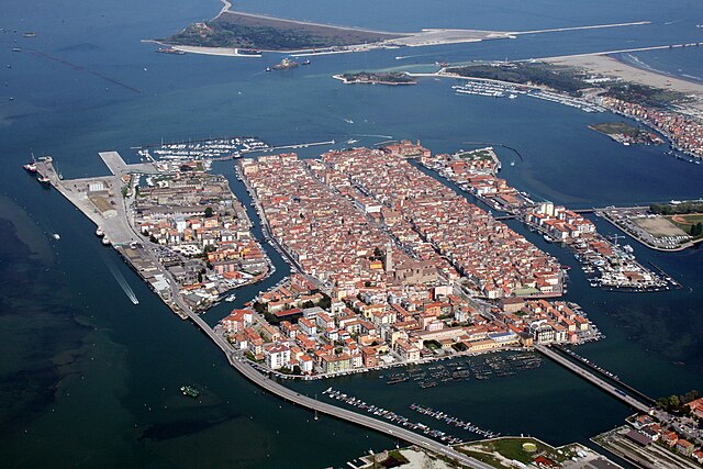

Chioggia
- Italian comune
Hiking in Chioggia
Chioggia, located on the Venetian Lagoon in Italy, is primarily known for its charming canals, colorful buildings, and rich fishing heritage rather than hiking trails. However, if you're looking to combine some outdoor exploration with the scenic beauty of the area, there are a few options nearby....
- Country:
- Postal Code: 30015
- Local Dialing Code: 041
- Licence Plate Code: VE
- Coordinates: 45° 13' 8" N, 12° 16' 43" E
- GPS tracks (wikiloc): [Link]
- AboveSeaLevel: 2 м m
- Area: 187.91 sq km
- Population: 49430
- Web site: [Link]


Venice
- city in northeastern Italy, sited on a group of 118 small islands
Hiking in Venice
Hiking in Venice might initially sound like an unusual combination, given that the city is renowned for its canals, waterways, and historic architecture rather than traditional hiking trails. However, there are several ways you can enjoy the outdoors and explore the surrounding natural beauty while still being in or near Venice:...
- Country:
- Postal Code: 30121–30176
- Local Dialing Code: 041
- Licence Plate Code: VE
- Coordinates: 45° 26' 23" N, 12° 19' 55" E
- GPS tracks (wikiloc): [Link]
- AboveSeaLevel: 2.56 м m
- Area: 415.9 sq km
- Population: 261905
- Web site: [Link]