Campoli Appennino (Campoli Appennino)
.svg)
- Italian comune
 Hiking in Campoli Appennino
Campoli Appennino is a picturesque village located in the heart of the Apennine Mountains in Italy. It offers a variety of hiking opportunities with stunning landscapes, diverse flora and fauna, and rich cultural heritage. Here are some highlights and tips for hiking in this area:
Trails and Routes
-
Natural Park of Abruzzo, Lazio, and Molise: Campoli serves as a gateway to this vast national park, which boasts numerous trails ranging from easy walks to challenging hikes. Here, you can enjoy breathtaking views of mountains, valleys, and the chance to spot wildlife like deer and golden eagles.
-
Local Trails: There are several local trails that connect Campoli Appennino to picturesque settings, such as:
- Valle di Campoli: A scenic route that takes you through lush valleys, dotted with wildflowers and streams.
- Monti Simbruini Trail: A more challenging hike that rewards with panoramic views of the surrounding ranges.
What to Expect
- Scenic Views: Hikes in the area provide dramatic vistas of the Apennine Mountains and the Lazio region. Look forward to encountering charming mountain villages along the way.
- Diverse Ecosystems: The region is home to a variety of ecosystems, including forests, meadows, and rocky terrains. Depending on the season, you may see a rich array of wildflowers or vibrant autumn foliage.
- Cultural Heritage: Besides natural beauty, many trails pass by historical landmarks and traditional Italian architecture, adding a cultural dimension to your hike.
Tips for Hiking in Campoli Appennino
- Preparation: Ensure you have a good map or GPS device, as trails can sometimes be less marked. Familiarize yourself with the route before setting out.
- Appropriate Gear: Wear sturdy hiking boots and appropriate clothing for changing weather conditions. Even in summer, be prepared for sudden changes in temperature.
- Water and Snacks: Carry plenty of water and snacks, as some trails can be quite remote without access to services.
- Timing Your Hike: Early morning hikes are ideal for avoiding crowds and enjoying cooler temperatures. Sunset hikes can provide stunning views, so plan accordingly.
Local Resources
- Guided Tours: Consider seeking out local hiking guides or organizations. They can offer invaluable insights into the area's natural history and ensure a safe and educational experience.
- Visitor Centers: Stop by local visitor centers for updated trail information and recommendations based on your skill level.
Overall, hiking in and around Campoli Appennino is a rewarding experience for outdoor enthusiasts and nature lovers alike, offering an unforgettable exploration of Italy's natural beauty.
- Country:

- Postal Code: 03030
- Local Dialing Code: 0776
- Licence Plate Code: FR
- Coordinates: 41° 44' 0" N, 13° 41' 0" E


- GPS tracks (wikiloc): [Link]
- AboveSeaLevel: 650 м m
- Area: 32.43 sq km
- Population: 1686
- Web site: http://www.comune.castrocielo.fr.it/
- Wikipedia en: wiki(en)
- Wikipedia: wiki(it)
- Wikidata storage: Wikidata: Q116564
- Wikipedia Commons Category: [Link]
- Freebase ID: [/m/0gm95c]
- GeoNames ID: Alt: [6536979]
- VIAF ID: Alt: [304920986]
- OSM relation ID: [41503]
- ISTAT ID: 060016
- Italian cadastre code: B543
Shares border with regions:
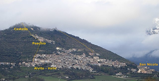

Alvito
- Italian comune
Hiking in Alvito
Alvito, located in the province of Frosinone in the Lazio region of Italy, is surrounded by beautiful natural landscapes, including the Abruzzo, Lazio, and Molise National Park. Hiking in this area offers a wonderful experience of both stunning scenery and cultural heritage....
- Country:
- Postal Code: 03041
- Local Dialing Code: 0776
- Licence Plate Code: FR
- Coordinates: 41° 41' 24" N, 13° 44' 53" E
- GPS tracks (wikiloc): [Link]
- AboveSeaLevel: 475 м m
- Area: 51.72 sq km
- Population: 2650
- Web site: [Link]
Broccostella
- Italian comune
Hiking in Broccostella
Broccostella is a charming town nestled in the province of Frosinone, Italy, and it's surrounded by beautiful natural landscapes that make it a great destination for hiking enthusiasts. While it may not be as widely known as other hiking locations in Italy, it offers a variety of trails that cater to different skill levels....
- Country:
- Postal Code: 03030
- Local Dialing Code: 0776
- Licence Plate Code: FR
- Coordinates: 41° 42' 0" N, 13° 38' 0" E
- GPS tracks (wikiloc): [Link]
- AboveSeaLevel: 293 м m
- Area: 11.79 sq km
- Population: 2708
- Web site: [Link]
Pescosolido
- Italian comune
Hiking in Pescosolido
Pescosolido is a small town located in the province of Frosinone in the Lazio region of Italy. Nestled in the Apennine Mountains, it offers beautiful landscapes and opportunities for hiking enthusiasts. Here’s some information to consider if you’re planning to hike in the area:...
- Country:
- Postal Code: 03030
- Local Dialing Code: 0776
- Licence Plate Code: FR
- Coordinates: 41° 44' 57" N, 13° 39' 27" E
- GPS tracks (wikiloc): [Link]
- AboveSeaLevel: 630 м m
- Area: 44.9 sq km
- Population: 1518
- Web site: [Link]

Posta Fibreno
- Italian comune
Hiking in Posta Fibreno
Posta Fibreno, located in the province of Frosinone in Italy's Lazio region, is a stunning destination for hiking enthusiasts. This area is celebrated for its picturesque landscapes, rich biodiversity, and the striking Fibreno Lake, which is a UNESCO-protected wetland. Here are some highlights and tips for hiking in Posta Fibreno:...
- Country:
- Postal Code: 03030
- Local Dialing Code: 0776
- Licence Plate Code: FR
- Coordinates: 41° 42' 0" N, 13° 42' 0" E
- GPS tracks (wikiloc): [Link]
- AboveSeaLevel: 430 м m
- Area: 9.8 sq km
- Population: 1101
- Web site: [Link]
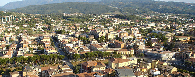

Sora, Lazio
- Italian comune
Hiking in Sora, Lazio
Sora, located in the Lazio region of Italy, is a wonderful destination for hikers and nature enthusiasts. Nestled in the Valle di Comino and surrounded by the Apennine Mountains, Sora offers various trails that cater to different skill levels, all set against stunning landscapes featuring lush forests, rivers, and picturesque views....
- Country:
- Postal Code: 03039
- Local Dialing Code: 0776
- Licence Plate Code: FR
- Coordinates: 41° 43' 0" N, 13° 37' 0" E
- GPS tracks (wikiloc): [Link]
- AboveSeaLevel: 300 м m
- Area: 72.13 sq km
- Population: 25972
- Web site: [Link]


Pescasseroli
- Italian comune
Hiking in Pescasseroli
Pescasseroli is a charming town located in the Abruzzo region of Italy, nestled within the heart of the Parco Nazionale d'Abruzzo, Lazio e Molise. This area is known for its stunning landscapes, diverse wildlife, and a variety of hiking trails that cater to different levels of experience....
- Country:
- Postal Code: 67032
- Local Dialing Code: 0863
- Licence Plate Code: AQ
- Coordinates: 41° 48' 18" N, 13° 47' 23" E
- GPS tracks (wikiloc): [Link]
- AboveSeaLevel: 1167 м m
- Area: 91.17 sq km
- Population: 2203
- Web site: [Link]


Villavallelonga
- Italian comune
Hiking in Villavallelonga
Villavallelonga is a charming village located in the Abruzzo region of Italy, nestled within the scenic landscape of the Apennine Mountains. Known for its natural beauty, Villavallelonga offers a variety of hiking opportunities suitable for all levels of experience....
- Country:
- Postal Code: 67050
- Local Dialing Code: 0863
- Licence Plate Code: AQ
- Coordinates: 41° 52' 21" N, 13° 37' 20" E
- GPS tracks (wikiloc): [Link]
- AboveSeaLevel: 1005 м m
- Area: 73.74 sq km
- Population: 879
- Web site: [Link]