Sora, Lazio (Sora)
.svg)
- Italian comune
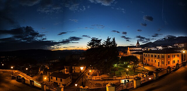
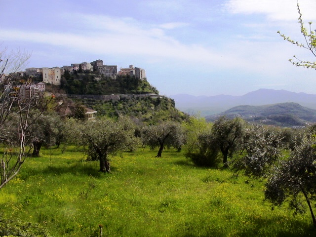
 Hiking in Sora, Lazio
Sora, located in the Lazio region of Italy, is a wonderful destination for hikers and nature enthusiasts. Nestled in the Valle di Comino and surrounded by the Apennine Mountains, Sora offers various trails that cater to different skill levels, all set against stunning landscapes featuring lush forests, rivers, and picturesque views.
Key Hiking Areas and Trails:
-
Monti Simbruini National Park: This large park is a short drive from Sora and features numerous trails that range from easy walks to challenging hikes. You can explore diverse flora and fauna as well as stunning geological formations.
-
Valle di Comino: The valley itself offers various trails, including those that follow ancient pathways used by locals for centuries. The routes often include historical landmarks, churches, and scenic viewpoints.
-
Trail to Mount Meta: This is a popular route for experienced hikers. The ascent is challenging but rewards you with breathtaking panoramic views of the surrounding Apennines.
-
Natural Reserves: Explore the nearby nature reserves like the Riserva Naturale di Monte Cavo, where you can find well-marked paths and learn about regional wildlife.
Tips for Hiking in Sora:
-
Weather and Gear: Check the weather conditions before your hike, as they can change rapidly in the mountains. Wear appropriate footwear and carry necessary supplies, including water, snacks, and a first aid kit.
-
Local Guides: Consider hiring a local guide or joining a guided tour, especially if you’re not familiar with the terrain. They can offer valuable insights into the area's history and ecology.
-
Respect Nature: Follow the Leave No Trace principles, ensuring that you minimize your impact on the environment. Stick to marked trails and don't disturb wildlife.
-
Seasonal Considerations: Spring and autumn are ideal times for hiking in Sora, as the weather is generally mild, and the landscapes are beautiful with blooming flowers or vibrant fall colors. Summer can get hot, and winter hikes can be challenging due to snow and icy conditions.
Conclusion:
Hiking in Sora, Lazio, can be a rewarding experience, offering beautiful natural scenery and an opportunity to connect with the region's rich history and culture. Whether you're an experienced hiker or a beginner seeking a day out in nature, Sora has a variety of options to explore.
- Country:

- Postal Code: 03039
- Local Dialing Code: 0776
- Licence Plate Code: FR
- Coordinates: 41° 43' 0" N, 13° 37' 0" E


- GPS tracks (wikiloc): [Link]
- AboveSeaLevel: 300 м m
- Area: 72.13 sq km
- Population: 25972
- Web site: http://www.comune.sora.fr.it/
- Wikipedia en: wiki(en)
- Wikipedia: wiki(it)
- Wikidata storage: Wikidata: Q117382
- Wikipedia Commons Gallery: [Link]
- Wikipedia Commons Category: [Link]
- Freebase ID: [/m/018htz]
- GeoNames ID: Alt: [6536997]
- OSM relation ID: [41487]
- archINFORM location ID: [45357]
- MusicBrainz area ID: [9dc7e993-c651-4b46-bff4-80c801aa1733]
- WOEID: [724334]
- UN/LOCODE: [ITRAO]
- Gran Enciclopèdia Catalana ID: [0063662]
- Digital Atlas of the Roman Empire ID: [21311]
- ISTAT ID: 060074
- Italian cadastre code: I838
Shares border with regions:


Arpino
- Italian comune
Hiking in Arpino
Arpino is a picturesque town located in the province of Frosinone, in the Lazio region of Italy. Surrounded by the breathtaking landscapes of the Italian countryside, it offers various hiking opportunities for outdoor enthusiasts. Here are some highlights of hiking in and around Arpino:...
- Country:
- Postal Code: 03033
- Local Dialing Code: 0776
- Licence Plate Code: FR
- Coordinates: 41° 38' 49" N, 13° 36' 42" E
- GPS tracks (wikiloc): [Link]
- AboveSeaLevel: 450 м m
- Area: 56.24 sq km
- Population: 7150
- Web site: [Link]
Broccostella
- Italian comune
Hiking in Broccostella
Broccostella is a charming town nestled in the province of Frosinone, Italy, and it's surrounded by beautiful natural landscapes that make it a great destination for hiking enthusiasts. While it may not be as widely known as other hiking locations in Italy, it offers a variety of trails that cater to different skill levels....
- Country:
- Postal Code: 03030
- Local Dialing Code: 0776
- Licence Plate Code: FR
- Coordinates: 41° 42' 0" N, 13° 38' 0" E
- GPS tracks (wikiloc): [Link]
- AboveSeaLevel: 293 м m
- Area: 11.79 sq km
- Population: 2708
- Web site: [Link]
Campoli Appennino
- Italian comune
Hiking in Campoli Appennino
Campoli Appennino is a picturesque village located in the heart of the Apennine Mountains in Italy. It offers a variety of hiking opportunities with stunning landscapes, diverse flora and fauna, and rich cultural heritage. Here are some highlights and tips for hiking in this area:...
- Country:
- Postal Code: 03030
- Local Dialing Code: 0776
- Licence Plate Code: FR
- Coordinates: 41° 44' 0" N, 13° 41' 0" E
- GPS tracks (wikiloc): [Link]
- AboveSeaLevel: 650 м m
- Area: 32.43 sq km
- Population: 1686
- Web site: [Link]

Castelliri
- Italian comune
Hiking in Castelliri
Castelliri is a small town located in the province of Frosinone in the Lazio region of Italy. Nestled in the picturesque Apennine Mountains, the area offers a variety of hiking opportunities, ranging from easy walks to more challenging trails, with stunning views of the surrounding countryside....
- Country:
- Postal Code: 03030
- Local Dialing Code: 0776
- Licence Plate Code: FR
- Coordinates: 41° 41' 0" N, 13° 33' 0" E
- GPS tracks (wikiloc): [Link]
- AboveSeaLevel: 261 м m
- Area: 15.32 sq km
- Population: 3411
- Web site: [Link]


Isola del Liri
- Italian comune
Hiking in Isola del Liri
Isola del Liri is a charming town in the province of Frosinone, in the Lazio region of Italy. Known for its beautiful waterfalls and rich history, it offers a variety of hiking opportunities for outdoor enthusiasts. Here are some key points you might consider when hiking in this area:...
- Country:
- Postal Code: 03036
- Local Dialing Code: 0776
- Licence Plate Code: FR
- Coordinates: 41° 41' 0" N, 13° 34' 0" E
- GPS tracks (wikiloc): [Link]
- AboveSeaLevel: 217 м m
- Area: 16.01 sq km
- Population: 11482
- Web site: [Link]


Monte San Giovanni Campano
- Italian comune
Hiking in Monte San Giovanni Campano
Monte San Giovanni Campano is a charming town located in the province of Frosinone, in the Lazio region of Italy. It is set in a picturesque landscape characterized by rolling hills, lush vegetation, and historical sites. Hiking in and around Monte San Giovanni Campano can provide an excellent opportunity for both nature lovers and those interested in exploring the historical backdrop of the region....
- Country:
- Postal Code: 03025
- Local Dialing Code: 0775
- Licence Plate Code: FR
- Coordinates: 41° 38' 0" N, 13° 31' 0" E
- GPS tracks (wikiloc): [Link]
- AboveSeaLevel: 420 м m
- Area: 48.71 sq km
- Population: 12706
- Web site: [Link]
Pescosolido
- Italian comune
Hiking in Pescosolido
Pescosolido is a small town located in the province of Frosinone in the Lazio region of Italy. Nestled in the Apennine Mountains, it offers beautiful landscapes and opportunities for hiking enthusiasts. Here’s some information to consider if you’re planning to hike in the area:...
- Country:
- Postal Code: 03030
- Local Dialing Code: 0776
- Licence Plate Code: FR
- Coordinates: 41° 44' 57" N, 13° 39' 27" E
- GPS tracks (wikiloc): [Link]
- AboveSeaLevel: 630 м m
- Area: 44.9 sq km
- Population: 1518
- Web site: [Link]

Veroli
- Italian comune
Hiking in Veroli
Veroli, a charming town situated in the province of Frosinone in the Lazio region of Italy, offers excellent opportunities for hiking enthusiasts. Nestled in the beautiful hills of the Ciociaria area, Veroli boasts stunning landscapes, rich history, and a variety of trails suitable for different experience levels....
- Country:
- Postal Code: 03029
- Local Dialing Code: 0775
- Licence Plate Code: FR
- Coordinates: 41° 41' 0" N, 13° 25' 0" E
- GPS tracks (wikiloc): [Link]
- AboveSeaLevel: 594 м m
- Area: 119.65 sq km
- Population: 20414
- Web site: [Link]


Balsorano
- Italian comune
Hiking in Balsorano
Balsorano, located in the Abruzzo region of Italy, is a charming destination that offers a variety of hiking opportunities amid scenic landscapes. The area is characterized by its mountainous terrain, dense forests, and picturesque valleys, making it a great spot for outdoor enthusiasts....
- Country:
- Postal Code: 67052
- Local Dialing Code: 0863
- Licence Plate Code: AQ
- Coordinates: 41° 48' 35" N, 13° 33' 35" E
- GPS tracks (wikiloc): [Link]
- AboveSeaLevel: 340 м m
- Area: 58.85 sq km
- Population: 3455
- Web site: [Link]