Campomarino (Campomarino)
.svg)
- Italian comune
 Hiking in Campomarino
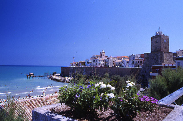
Campomarino is a charming coastal town located in the Molise region of Italy, known for its beautiful beaches, historical sites, and proximity to nature. While it may not be as famous for hiking as other regions in Italy, there are certainly opportunities for outdoor enthusiasts to explore the surrounding areas. Here are some aspects to consider if you're thinking about hiking in and around Campomarino:
Trails and Natural Attractions:
-
Beaches and Coastal Paths: The coastline near Campomarino offers scenic walking paths along the shore. Walking along the beach can provide both a relaxing and invigorating experience, with stunning views of the Adriatic Sea.
-
Nearby Nature Reserves: The nearby Parco Nazionale del Gargano and Parco Regionale del Matese offer more extensive hiking opportunities with various trails ranging from easy walks to more challenging hikes. These parks are home to diverse flora and fauna, as well as picturesque landscapes.
-
Countryside and Vineyards: The area around Campomarino features agricultural land, vineyards, and olive groves. Some trails may take you through charming rural landscapes where you can enjoy the local culture and cuisine.
Best Practices:
-
Preparation: Ensure you prepare for your hike by checking the weather, wearing appropriate footwear, and bringing sufficient water and snacks.
-
Guided Tours: Consider joining local guided hiking tours, as they often provide insights about the area’s history, culture, and natural features that you may not learn on your own.
-
Respect Nature: When hiking, follow the Leave No Trace principles to preserve the environment. Stay on marked paths and avoid disturbing wildlife.
Seasonal Considerations:
-
Spring and Fall: These seasons are typically the best times for hiking in this area, with mild temperatures and beautiful natural scenery.
-
Summer: While summer can be hot, early morning or late afternoon hikes can provide a pleasant experience before the sun gets too intense.
Recommendations:
If you're planning to hike in Campomarino, consider exploring the nearby mountains or reserves for a more diverse hiking experience. Additionally, engaging with local outdoor clubs or visitor centers can provide more updated information on trail conditions and recommendations.
Overall, hiking around Campomarino can be a rewarding experience with a blend of nature, culture, and beautiful scenery!
- Country:

- Postal Code: 86042
- Local Dialing Code: 0875
- Licence Plate Code: CB
- Coordinates: 41° 57' 24" N, 15° 2' 4" E


- GPS tracks (wikiloc): [Link]
- AboveSeaLevel: 52 м m
- Area: 76.68 sq km
- Population: 8074
- Web site: http://www.comune.campomarino.cb.it/
- Wikipedia en: wiki(en)
- Wikipedia: wiki(it)
- Wikidata storage: Wikidata: Q277418
- Wikipedia Commons Category: [Link]
- Freebase ID: [/m/0gnnm8]
- GeoNames ID: Alt: [6538900]
- OSM relation ID: [41624]
- UN/LOCODE: [ITMPR]
- Digital Atlas of the Roman Empire ID: [29128]
- ISTAT ID: 070010
- Italian cadastre code: B550
Shares border with regions:

Termoli
- Italian comune
Hiking in Termoli
Termoli is a charming coastal town located in the Molise region of Italy, known for its beautiful beaches, historic architecture, and stunning views of the Adriatic Sea. While Termoli itself may not be renowned specifically for hiking, there are several opportunities for outdoor enthusiasts in the surrounding areas and nearby countryside. Here are some highlights for hiking in and around Termoli:...
- Country:
- Postal Code: 86039
- Local Dialing Code: 0875
- Licence Plate Code: CB
- Coordinates: 42° 0' 10" N, 14° 59' 41" E
- GPS tracks (wikiloc): [Link]
- AboveSeaLevel: 15 м m
- Area: 55.64 sq km
- Population: 33583
- Web site: [Link]


Guglionesi
- Italian comune
Hiking in Guglionesi
Guglionesi is a charming village located in the Molise region of Italy, surrounded by beautiful countryside and rolling hills, making it a great destination for hiking enthusiasts. Here's what you can expect when hiking in and around Guglionesi:...
- Country:
- Postal Code: 86034
- Local Dialing Code: 0875
- Licence Plate Code: CB
- Coordinates: 41° 55' 0" N, 14° 55' 0" E
- GPS tracks (wikiloc): [Link]
- AboveSeaLevel: 369 м m
- Area: 100.95 sq km
- Population: 5246
- Web site: [Link]
Portocannone
- Italian comune
Hiking in Portocannone
Portocannone is a small town located in the Molise region of Italy, known for its picturesque landscapes and proximity to both the Adriatic coast and the Apennine Mountains. While it may not be as well-known as some other hiking destinations in Italy, the area offers opportunities for outdoor enthusiasts to enjoy hiking amidst natural beauty and local culture....
- Country:
- Postal Code: 86045
- Local Dialing Code: 0875
- Licence Plate Code: CB
- Coordinates: 41° 55' 0" N, 15° 1' 0" E
- GPS tracks (wikiloc): [Link]
- AboveSeaLevel: 148 м m
- Area: 13.11 sq km
- Population: 2490
- Web site: [Link]


San Martino in Pensilis
- Italian comune
Hiking in San Martino in Pensilis
San Martino in Pensilis is a charming municipality located in the Molise region of Italy. While it may not be as widely known for hiking as some other Italian destinations, it offers a variety of options for those looking to explore its picturesque landscapes....
- Country:
- Postal Code: 86046
- Local Dialing Code: 0875
- Licence Plate Code: CB
- Coordinates: 41° 52' 0" N, 15° 1' 0" E
- GPS tracks (wikiloc): [Link]
- AboveSeaLevel: 15 м m
- Area: 100.66 sq km
- Population: 4752
- Web site: [Link]
Chieuti
- Italian comune
Hiking in Chieuti
Chieuti, a small town in the Apulia region of Italy, offers a unique hiking experience, especially for those who enjoy exploring rural landscapes and coastal areas. While Chieuti itself is not widely known as a hiking hotspot, it is situated near the northern part of the Gargano National Park and the stunning Adriatic coastline, which provides numerous opportunities for outdoor enthusiasts....
- Country:
- Postal Code: 71010
- Local Dialing Code: 0882
- Licence Plate Code: FG
- Coordinates: 41° 51' 0" N, 15° 9' 0" E
- GPS tracks (wikiloc): [Link]
- AboveSeaLevel: 221 м m
- Area: 61.52 sq km
- Population: 1675
- Web site: [Link]