canton of Betz (canton de Betz)
- canton of France (until March 2015)
- Country:

- Capital: Betz
- Coordinates: 49° 8' 53" N, 2° 59' 35" E


- GPS tracks (wikiloc): [Link]
- Wikidata storage: Wikidata: Q620925
- INSEE canton code: [6005]
Includes regions:


Étavigny
- commune in Oise, France
- Country:
- Postal Code: 60620
- Coordinates: 49° 7' 13" N, 2° 58' 44" E
- GPS tracks (wikiloc): [Link]
- Area: 7.17 sq km
- Population: 154


Cuvergnon
- commune in Oise, France
- Country:
- Postal Code: 60620
- Coordinates: 49° 10' 26" N, 2° 59' 21" E
- GPS tracks (wikiloc): [Link]
- Area: 7.33 sq km
- Population: 292

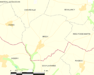
Brégy
- commune in Oise, France
- Country:
- Postal Code: 60440
- Coordinates: 49° 4' 58" N, 2° 51' 55" E
- GPS tracks (wikiloc): [Link]
- Area: 13.17 sq km
- Population: 606


Boursonne
- commune in Oise, France
- Country:
- Postal Code: 60141
- Coordinates: 49° 12' 9" N, 3° 2' 43" E
- GPS tracks (wikiloc): [Link]
- Area: 3.44 sq km
- Population: 300

Antilly
- commune in Oise, France
- Country:
- Postal Code: 60620
- Coordinates: 49° 9' 8" N, 2° 59' 1" E
- GPS tracks (wikiloc): [Link]
- Area: 3.64 sq km
- Population: 279


Boullarre
- commune in Oise, France
- Country:
- Postal Code: 60620
- Coordinates: 49° 7' 51" N, 3° 0' 15" E
- GPS tracks (wikiloc): [Link]
- Area: 7.58 sq km
- Population: 226


Bouillancy
- commune in Oise, France
- Country:
- Postal Code: 60620
- Coordinates: 49° 6' 45" N, 2° 55' 2" E
- GPS tracks (wikiloc): [Link]
- Area: 13.59 sq km
- Population: 379


Autheuil-en-Valois
- commune in Oise, France
- Country:
- Postal Code: 60890
- Coordinates: 49° 10' 19" N, 3° 3' 39" E
- GPS tracks (wikiloc): [Link]
- Area: 9.24 sq km
- Population: 278
- Web site: [Link]


Acy-en-Multien
- commune in Oise, France
- Country:
- Postal Code: 60620
- Coordinates: 49° 6' 18" N, 2° 57' 17" E
- GPS tracks (wikiloc): [Link]
- Area: 11.47 sq km
- Population: 834
- Web site: [Link]


La Villeneuve-sous-Thury
- commune in Oise, France
- Country:
- Postal Code: 60890
- Coordinates: 49° 9' 21" N, 3° 3' 43" E
- GPS tracks (wikiloc): [Link]
- AboveSeaLevel: 134 м m
- Area: 4.32 sq km
- Population: 163

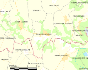
Rosoy-en-Multien
- commune in Oise, France
- Country:
- Postal Code: 60620
- Coordinates: 49° 5' 48" N, 2° 59' 38" E
- GPS tracks (wikiloc): [Link]
- Area: 8.49 sq km
- Population: 495


Villers-Saint-Genest
- commune in Oise, France
- Country:
- Postal Code: 60620
- Coordinates: 49° 8' 32" N, 2° 54' 21" E
- GPS tracks (wikiloc): [Link]
- Area: 9.66 sq km
- Population: 377


Réez-Fosse-Martin
- commune in Oise, France
- Country:
- Postal Code: 60620
- Coordinates: 49° 6' 43" N, 2° 55' 5" E
- GPS tracks (wikiloc): [Link]
- Area: 7.11 sq km
- Population: 153


Rouvres-en-Multien
- commune in Oise, France
- Country:
- Postal Code: 60620
- Coordinates: 49° 6' 39" N, 3° 1' 26" E
- GPS tracks (wikiloc): [Link]
- AboveSeaLevel: 141 м m
- Area: 8.12 sq km
- Population: 456


Thury-en-Valois
- commune in Oise, France
- Country:
- Postal Code: 60890
- Coordinates: 49° 9' 26" N, 3° 1' 28" E
- GPS tracks (wikiloc): [Link]
- Area: 11.26 sq km
- Population: 485


Varinfroy
- commune in Oise, France
- Country:
- Postal Code: 60890
- Coordinates: 49° 5' 57" N, 3° 2' 39" E
- GPS tracks (wikiloc): [Link]
- Area: 2.95 sq km
- Population: 277


Neufchelles
- commune in Oise, France
- Country:
- Postal Code: 60890
- Coordinates: 49° 6' 59" N, 3° 3' 42" E
- GPS tracks (wikiloc): [Link]
- Area: 6.46 sq km
- Population: 370
- Web site: [Link]


Marolles
- commune in Oise, France
- Country:
- Postal Code: 60890
- Coordinates: 49° 10' 12" N, 3° 6' 18" E
- GPS tracks (wikiloc): [Link]
- Area: 13.22 sq km
- Population: 690


Ivors
- commune in Oise, France
- Country:
- Postal Code: 60141
- Coordinates: 49° 12' 5" N, 3° 0' 59" E
- GPS tracks (wikiloc): [Link]
- Area: 8.35 sq km
- Population: 251


Bargny
- commune in Oise, France
- Country:
- Postal Code: 60620
- Coordinates: 49° 10' 42" N, 2° 57' 22" E
- GPS tracks (wikiloc): [Link]
- Area: 7.54 sq km
- Population: 325


Lévignen
- commune in Oise, France
- Country:
- Postal Code: 60800
- Coordinates: 49° 11' 49" N, 2° 54' 52" E
- GPS tracks (wikiloc): [Link]
- Area: 13.9 sq km
- Population: 915


Mareuil-sur-Ourcq
- commune in Oise, France
- Country:
- Postal Code: 60890
- Coordinates: 49° 8' 11" N, 3° 4' 38" E
- GPS tracks (wikiloc): [Link]
- Area: 10.14 sq km
- Population: 1617
- Web site: [Link]


Gondreville
- commune in Oise, France
- Country:
- Postal Code: 60117
- Coordinates: 49° 12' 58" N, 2° 57' 17" E
- GPS tracks (wikiloc): [Link]
- Area: 7.09 sq km
- Population: 212


Betz
- commune in Oise, France
- Country:
- Postal Code: 60620
- Coordinates: 49° 9' 24" N, 2° 57' 20" E
- GPS tracks (wikiloc): [Link]
- Area: 15.39 sq km
- Population: 1156


Ormoy-le-Davien
- commune in Oise, France
- Country:
- Postal Code: 60620
- Coordinates: 49° 11' 44" N, 2° 57' 32" E
- GPS tracks (wikiloc): [Link]
- Area: 3.95 sq km
- Population: 355