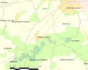
Lévignen (Lévignen)
- commune in Oise, France
- Country:

- Postal Code: 60800
- Coordinates: 49° 11' 49" N, 2° 54' 52" E


- GPS tracks (wikiloc): [Link]
- Area: 13.9 sq km
- Population: 915
- Wikipedia en: wiki(en)
- Wikipedia: wiki(fr)
- Wikidata storage: Wikidata: Q1346959
- Wikipedia Commons Category: [Link]
- Freebase ID: [/m/03qg4w3]
- GeoNames ID: Alt: [2998797]
- SIREN number: [216003558]
- BnF ID: [146349046]
- PACTOLS thesaurus ID: [pcrtv208bbrIlP]
- INSEE municipality code: 60358
Shares border with regions:


Boissy-Fresnoy
- commune in Oise, France
- Country:

- Postal Code: 60440
- Coordinates: 49° 9' 49" N, 2° 52' 14" E


- GPS tracks (wikiloc): [Link]
- Area: 15.87 sq km
- Population: 1039


Rouville
- commune in Oise, France
- Country:

- Postal Code: 60800
- Coordinates: 49° 12' 28" N, 2° 52' 21" E


- GPS tracks (wikiloc): [Link]
- Area: 7 sq km
- Population: 263
- Web site: [Link]


Bargny
- commune in Oise, France
- Country:

- Postal Code: 60620
- Coordinates: 49° 10' 42" N, 2° 57' 22" E


- GPS tracks (wikiloc): [Link]
- Area: 7.54 sq km
- Population: 325


Ormoy-Villers
- commune in Oise, France
- Country:

- Postal Code: 60800
- Coordinates: 49° 11' 47" N, 2° 50' 25" E


- GPS tracks (wikiloc): [Link]
- Area: 10.37 sq km
- Population: 633


Crépy-en-Valois
- commune in Oise, France
- Country:

- Postal Code: 60800
- Coordinates: 49° 14' 4" N, 2° 53' 15" E


- GPS tracks (wikiloc): [Link]
- AboveSeaLevel: 93 м m
- Area: 16.28 sq km
- Population: 15049
- Web site: [Link]


Gondreville
- commune in Oise, France
- Country:

- Postal Code: 60117
- Coordinates: 49° 12' 58" N, 2° 57' 17" E


- GPS tracks (wikiloc): [Link]
- Area: 7.09 sq km
- Population: 212


Betz
- commune in Oise, France
- Country:

- Postal Code: 60620
- Coordinates: 49° 9' 24" N, 2° 57' 20" E


- GPS tracks (wikiloc): [Link]
- Area: 15.39 sq km
- Population: 1156


Ormoy-le-Davien
- commune in Oise, France
- Country:

- Postal Code: 60620
- Coordinates: 49° 11' 44" N, 2° 57' 32" E


- GPS tracks (wikiloc): [Link]
- Area: 3.95 sq km
- Population: 355
