canton of Chalabre (canton de Chalabre)
- canton of France (until March 2015)
- Country:

- Capital: Chalabre
- Coordinates: 42° 59' 5" N, 2° 0' 25" E


- GPS tracks (wikiloc): [Link]
- Area: 201.98 sq km
- Population: 3257
- Wikidata storage: Wikidata: Q948473
- Wikipedia Commons Category: [Link]
- INSEE canton code: [1111]
Includes regions:


Caudeval
- former commune in Aude, France
- Country:
- Postal Code: 11230
- Coordinates: 43° 4' 32" N, 1° 58' 32" E
- GPS tracks (wikiloc): [Link]
- Area: 7.19 sq km
- Population: 163


Rivel
- commune in Aude, France
- Country:
- Postal Code: 11230
- Coordinates: 42° 56' 40" N, 2° 0' 1" E
- GPS tracks (wikiloc): [Link]
- Area: 24.3 sq km
- Population: 196
Courtauly
- commune in Aude, France
- Country:
- Postal Code: 11230
- Coordinates: 43° 2' 25" N, 2° 2' 35" E
- GPS tracks (wikiloc): [Link]
- Area: 7.72 sq km
- Population: 70
Saint-Benoît
- commune in Aude, France
- Country:
- Postal Code: 11230
- Coordinates: 43° 1' 4" N, 2° 3' 43" E
- GPS tracks (wikiloc): [Link]
- Area: 21.31 sq km
- Population: 103


Sainte-Colombe-sur-l'Hers
- commune in Aude, France
- Country:
- Postal Code: 11230
- Coordinates: 42° 57' 9" N, 1° 57' 58" E
- GPS tracks (wikiloc): [Link]
- Area: 10.61 sq km
- Population: 447

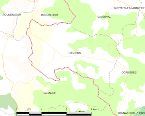
Tréziers
- commune in Aude, France
- Country:
- Postal Code: 11230
- Coordinates: 43° 3' 25" N, 1° 57' 15" E
- GPS tracks (wikiloc): [Link]
- Area: 6.41 sq km
- Population: 102


Peyrefitte-du-Razès
- commune in Aude, France
- Country:
- Postal Code: 11230
- Coordinates: 43° 3' 39" N, 2° 1' 23" E
- GPS tracks (wikiloc): [Link]
- Area: 6.72 sq km
- Population: 43
Montjardin
- commune in Aude, France
- Country:
- Postal Code: 11230
- Coordinates: 42° 58' 58" N, 2° 1' 39" E
- GPS tracks (wikiloc): [Link]
- Area: 14.11 sq km
- Population: 89


Saint-Jean-de-Paracol
- commune in Aude, France
- Country:
- Postal Code: 11260
- Coordinates: 42° 56' 9" N, 2° 6' 50" E
- GPS tracks (wikiloc): [Link]
- Area: 7.08 sq km
- Population: 117

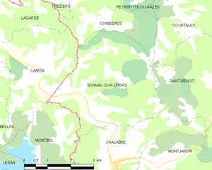
Sonnac-sur-l'Hers
- commune in Aude, France
- Country:
- Postal Code: 11230
- Coordinates: 43° 0' 14" N, 1° 59' 35" E
- GPS tracks (wikiloc): [Link]
- Area: 13.74 sq km
- Population: 146


Gueytes-et-Labastide
- former commune in Aude, France
- Country:
- Postal Code: 11230
- Coordinates: 43° 4' 8" N, 2° 0' 22" E
- GPS tracks (wikiloc): [Link]
- Area: 4.81 sq km
- Population: 44
Villefort
- commune in Aude, France
- Country:
- Postal Code: 11230
- Coordinates: 42° 57' 13" N, 2° 1' 57" E
- GPS tracks (wikiloc): [Link]
- Area: 12.67 sq km
- Population: 92
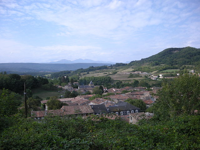

Chalabre
- commune in Aude, France
- Country:
- Postal Code: 11230
- Coordinates: 42° 59' 2" N, 2° 0' 23" E
- GPS tracks (wikiloc): [Link]
- Area: 15.49 sq km
- Population: 1111

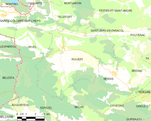
Puivert
- commune in Aude, France
- Country:
- Postal Code: 11230
- Coordinates: 42° 55' 14" N, 2° 2' 49" E
- GPS tracks (wikiloc): [Link]
- Area: 41.29 sq km
- Population: 522


Corbières
- commune in Aude, France
- Country:
- Postal Code: 11230
- Coordinates: 43° 2' 25" N, 1° 59' 24" E
- GPS tracks (wikiloc): [Link]
- Area: 8.53 sq km
- Population: 31