canton of Méry-sur-Seine (canton de Méry-sur-Seine)
- canton of France
- Country:

- Capital: Méry-sur-Seine
- Coordinates: 48° 30' 30" N, 3° 53' 25" E


- GPS tracks (wikiloc): [Link]
- Wikidata storage: Wikidata: Q1726429
- INSEE canton code: [1014]
Includes regions:

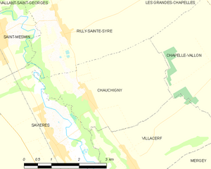
Chauchigny
- commune in Aube, France
- Country:
- Postal Code: 10170
- Coordinates: 48° 25' 24" N, 3° 58' 4" E
- GPS tracks (wikiloc): [Link]
- Area: 9.72 sq km
- Population: 264


Droupt-Saint-Basle
- commune in Aube, France
- Country:
- Postal Code: 10170
- Coordinates: 48° 28' 32" N, 3° 56' 26" E
- GPS tracks (wikiloc): [Link]
- Area: 18.61 sq km
- Population: 352
Charny-le-Bachot
- commune in Aube, France
- Country:
- Postal Code: 10380
- Coordinates: 48° 33' 10" N, 3° 56' 38" E
- GPS tracks (wikiloc): [Link]
- Area: 13.64 sq km
- Population: 248


Droupt-Sainte-Marie
- commune in Aube, France
- Country:
- Postal Code: 10170
- Coordinates: 48° 29' 40" N, 3° 55' 27" E
- GPS tracks (wikiloc): [Link]
- Area: 14.4 sq km
- Population: 235


Chapelle-Vallon
- commune in Aube, France
- Country:
- Postal Code: 10700
- Coordinates: 48° 26' 8" N, 4° 2' 24" E
- GPS tracks (wikiloc): [Link]
- Area: 19.24 sq km
- Population: 246


Vallant-Saint-Georges
- commune in Aube, France
- Country:
- Postal Code: 10170
- Coordinates: 48° 28' 10" N, 3° 54' 11" E
- GPS tracks (wikiloc): [Link]
- Area: 17.86 sq km
- Population: 376


Saint-Mesmin
- commune in Aube, France
- Country:
- Postal Code: 10280
- Coordinates: 48° 26' 38" N, 3° 55' 32" E
- GPS tracks (wikiloc): [Link]
- Area: 16.15 sq km
- Population: 831


Étrelles-sur-Aube
- commune in Aube, France
- Country:
- Postal Code: 10170
- Coordinates: 48° 33' 37" N, 3° 52' 19" E
- GPS tracks (wikiloc): [Link]
- Area: 10.43 sq km
- Population: 155
Châtres
- commune in Aube, France
- Country:
- Postal Code: 10510
- Coordinates: 48° 30' 8" N, 3° 50' 55" E
- GPS tracks (wikiloc): [Link]
- Area: 15.76 sq km
- Population: 705


Fontaine-les-Grès
- commune in Aube, France
- Country:
- Postal Code: 10280
- Coordinates: 48° 25' 25" N, 3° 54' 29" E
- GPS tracks (wikiloc): [Link]
- Area: 12.16 sq km
- Population: 872


Salon
- commune in Aube, France
- Country:
- Postal Code: 10700
- Coordinates: 48° 38' 24" N, 4° 0' 14" E
- GPS tracks (wikiloc): [Link]
- Area: 21.67 sq km
- Population: 125


Plancy-l'Abbaye
- commune in Aube, France
- Country:
- Postal Code: 10380
- Coordinates: 48° 34' 12" N, 3° 58' 6" E
- GPS tracks (wikiloc): [Link]
- AboveSeaLevel: 82 м m
- Area: 41.38 sq km
- Population: 984
- Web site: [Link]


Prémierfait
- commune in Aube, France
- Country:
- Postal Code: 10170
- Coordinates: 48° 30' 9" N, 4° 1' 39" E
- GPS tracks (wikiloc): [Link]
- Area: 14.79 sq km
- Population: 94

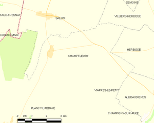
Champfleury
- commune in Aube, France
- Country:
- Postal Code: 10700
- Coordinates: 48° 37' 1" N, 4° 0' 22" E
- GPS tracks (wikiloc): [Link]
- AboveSeaLevel: 119 м m
- Area: 17.98 sq km
- Population: 114

Savières
- commune in Aube, France
- Country:
- Postal Code: 10600
- Coordinates: 48° 24' 26" N, 3° 57' 6" E
- GPS tracks (wikiloc): [Link]
- Area: 18.54 sq km
- Population: 1018
- Web site: [Link]


Viâpres-le-Petit
- commune in Aube, France
- Country:
- Postal Code: 10380
- Coordinates: 48° 33' 45" N, 4° 2' 32" E
- GPS tracks (wikiloc): [Link]
- Area: 11.13 sq km
- Population: 117


Saint-Oulph
- commune in Aube, France
- Country:
- Postal Code: 10170
- Coordinates: 48° 31' 7" N, 3° 52' 1" E
- GPS tracks (wikiloc): [Link]
- Area: 10.94 sq km
- Population: 268
Bessy
- commune in Aube, France
- Country:
- Postal Code: 10170
- Coordinates: 48° 32' 50" N, 4° 1' 23" E
- GPS tracks (wikiloc): [Link]
- AboveSeaLevel: 87 м m
- Area: 7.03 sq km
- Population: 138


Rhèges
- commune in Aube, France
- Country:
- Postal Code: 10170
- Coordinates: 48° 32' 51" N, 3° 59' 50" E
- GPS tracks (wikiloc): [Link]
- Area: 14.8 sq km
- Population: 245
Mesgrigny
- commune in Aube, France
- Country:
- Postal Code: 10170
- Coordinates: 48° 29' 13" N, 3° 52' 57" E
- GPS tracks (wikiloc): [Link]
- Area: 7.27 sq km
- Population: 309


Les Grandes-Chapelles
- commune in Aube, France
- Country:
- Postal Code: 10170
- Coordinates: 48° 28' 0" N, 4° 0' 58" E
- GPS tracks (wikiloc): [Link]
- Area: 22.1 sq km
- Population: 394
Longueville-sur-Aube
- commune in Aube, France
- Country:
- Postal Code: 10170
- Coordinates: 48° 33' 17" N, 3° 54' 47" E
- GPS tracks (wikiloc): [Link]
- Area: 11.64 sq km
- Population: 126
Rilly-Sainte-Syre
- commune in Aube, France
- Country:
- Postal Code: 10280
- Coordinates: 48° 26' 38" N, 3° 57' 27" E
- GPS tracks (wikiloc): [Link]
- Area: 14.16 sq km
- Population: 230


Méry-sur-Seine
- commune in Aube, France
- Country:
- Postal Code: 10170
- Coordinates: 48° 30' 38" N, 3° 53' 22" E
- GPS tracks (wikiloc): [Link]
- Area: 12.42 sq km
- Population: 1499
- Web site: [Link]
Boulages
- commune in Aube, France
- Country:
- Postal Code: 10380
- Coordinates: 48° 34' 42" N, 3° 54' 54" E
- GPS tracks (wikiloc): [Link]
- Area: 11.54 sq km
- Population: 235
- Web site: [Link]