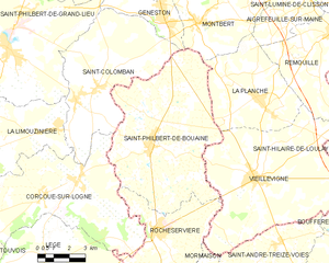
canton of Rocheservière (canton de Rocheservière)
- canton of France
- Country:

- Capital: Rocheservière
- Coordinates: 46° 55' 41" N, 1° 26' 56" E


- GPS tracks (wikiloc): [Link]
- Wikidata storage: Wikidata: Q1726976
- INSEE canton code: [8522]
Includes regions:


L'Herbergement
- commune in Vendée, France
- Country:

- Postal Code: 85260
- Coordinates: 46° 54' 33" N, 1° 22' 37" E


- GPS tracks (wikiloc): [Link]
- Area: 16.75 sq km
- Population: 3119
- Web site: [Link]


Saint-Sulpice-le-Verdon
- former commune in Vendée, France
- Country:

- Postal Code: 85260
- Coordinates: 46° 53' 36" N, 1° 25' 15" E


- GPS tracks (wikiloc): [Link]
- Area: 14.07 sq km
- Population: 1036
- Web site: [Link]


Mormaison
- former commune in Vendée, France
- Country:

- Postal Code: 85260
- Coordinates: 46° 54' 25" N, 1° 27' 0" E


- GPS tracks (wikiloc): [Link]
- AboveSeaLevel: 55 м m
- Area: 15.44 sq km
- Population: 1122


Saint-Philbert-de-Bouaine
- commune in Vendée, France
- Country:

- Postal Code: 85660
- Coordinates: 46° 59' 7" N, 1° 31' 15" E


- GPS tracks (wikiloc): [Link]
- Area: 50.16 sq km
- Population: 3326
- Web site: [Link]


Rocheservière
- commune in Vendée, France
- Country:

- Postal Code: 85620
- Coordinates: 46° 56' 20" N, 1° 30' 33" E


- GPS tracks (wikiloc): [Link]
- Area: 28.15 sq km
- Population: 3221
- Web site: [Link]


Saint-André-Treize-Voies
- former commune in Vendée, France
- Country:

- Postal Code: 85260
- Coordinates: 46° 56' 4" N, 1° 24' 44" E


- GPS tracks (wikiloc): [Link]
- Area: 18.96 sq km
- Population: 1422