Rocheservière (Rocheservière)

- commune in Vendée, France
- Country:

- Postal Code: 85620
- Coordinates: 46° 56' 20" N, 1° 30' 33" E


- GPS tracks (wikiloc): [Link]
- Area: 28.15 sq km
- Population: 3221
- Web site: http://www.rocheserviere.fr/
- Wikipedia en: wiki(en)
- Wikipedia: wiki(fr)
- Wikidata storage: Wikidata: Q617864
- Wikipedia Commons Category: [Link]
- Freebase ID: [/m/03qhkjb]
- SIREN number: [218501906]
- BnF ID: [152783143]
- MusicBrainz area ID: [217a026d-1cd7-4525-a861-187cdff685ab]
- WOEID: [619693]
- INSEE municipality code: 85190
Shares border with regions:


Corcoué-sur-Logne
- commune in Loire-Atlantique, France
- Country:
- Postal Code: 44650
- Coordinates: 46° 57' 56" N, 1° 34' 37" E
- GPS tracks (wikiloc): [Link]
- AboveSeaLevel: 47 м m
- Area: 50.39 sq km
- Population: 2825
- Web site: [Link]

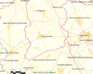
Vieillevigne
- commune in Loire-Atlantique, France
- Country:
- Postal Code: 44116
- Coordinates: 46° 58' 16" N, 1° 26' 0" E
- GPS tracks (wikiloc): [Link]
- Area: 51.76 sq km
- Population: 3964
- Web site: [Link]


Mormaison
- former commune in Vendée, France
- Country:
- Postal Code: 85260
- Coordinates: 46° 54' 25" N, 1° 27' 0" E
- GPS tracks (wikiloc): [Link]
- AboveSeaLevel: 55 м m
- Area: 15.44 sq km
- Population: 1122


Les Lucs-sur-Boulogne
- commune in Vendée, France
- Country:
- Postal Code: 85170
- Coordinates: 46° 50' 38" N, 1° 29' 37" E
- GPS tracks (wikiloc): [Link]
- Area: 53.15 sq km
- Population: 3392
- Web site: [Link]

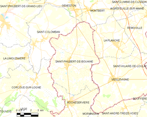
Saint-Philbert-de-Bouaine
- commune in Vendée, France
- Country:
- Postal Code: 85660
- Coordinates: 46° 59' 7" N, 1° 31' 15" E
- GPS tracks (wikiloc): [Link]
- Area: 50.16 sq km
- Population: 3326
- Web site: [Link]

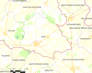
Legé
- commune in Loire-Atlantique, France
- Country:
- Postal Code: 44650
- Coordinates: 46° 53' 8" N, 1° 35' 56" E
- GPS tracks (wikiloc): [Link]
- Area: 63.32 sq km
- Population: 4491
- Web site: [Link]