canton of Saint-Flour-Sud (canton de Saint-Flour-Sud)
- canton of France (until March 2015)
- Country:

- Capital: Saint-Flour
- Coordinates: 45° 2' 4" N, 3° 5' 37" E


- GPS tracks (wikiloc): [Link]
- Wikidata storage: Wikidata: Q247718
- INSEE canton code: [1520]
Includes regions:


Les Ternes
- commune in Cantal, France
- Country:
- Postal Code: 15100
- Coordinates: 44° 59' 54" N, 3° 0' 49" E
- GPS tracks (wikiloc): [Link]
- AboveSeaLevel: 949 м m
- Area: 19.13 sq km
- Population: 589


Lavastrie
- former commune in Cantal, France
- Country:
- Postal Code: 15260
- Coordinates: 44° 56' 7" N, 3° 2' 32" E
- GPS tracks (wikiloc): [Link]
- Area: 24.14 sq km
- Population: 259


Villedieu
- commune in Cantal, France
- Country:
- Postal Code: 15100
- Coordinates: 44° 59' 56" N, 3° 3' 51" E
- GPS tracks (wikiloc): [Link]
- Area: 18.99 sq km
- Population: 542


Neuvéglise
- former commune in Cantal, France
- Country:
- Postal Code: 15260
- Coordinates: 44° 55' 41" N, 2° 59' 0" E
- GPS tracks (wikiloc): [Link]
- Area: 54.7 sq km
- Population: 1113
- Web site: [Link]

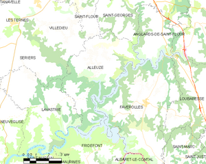
Alleuze
- commune in Cantal, France
- Country:
- Postal Code: 15100
- Coordinates: 44° 57' 44" N, 3° 5' 9" E
- GPS tracks (wikiloc): [Link]
- Area: 22.85 sq km
- Population: 212


Sériers
- former commune in Cantal, France
- Country:
- Postal Code: 15100
- Coordinates: 44° 58' 35" N, 3° 2' 22" E
- GPS tracks (wikiloc): [Link]
- Area: 12.62 sq km
- Population: 133

Valuéjols
- commune in Cantal, France
- Country:
- Postal Code: 15300
- Coordinates: 45° 3' 11" N, 2° 56' 2" E
- GPS tracks (wikiloc): [Link]
- Area: 38.51 sq km
- Population: 563
- Web site: [Link]


Tanavelle
- commune in Cantal, France
- Country:
- Postal Code: 15100
- Coordinates: 45° 1' 22" N, 2° 59' 54" E
- GPS tracks (wikiloc): [Link]
- Area: 13.58 sq km
- Population: 242
- Web site: [Link]
Cussac
- commune in Cantal, France
- Country:
- Postal Code: 15430
- Coordinates: 44° 59' 1" N, 2° 55' 57" E
- GPS tracks (wikiloc): [Link]
- Area: 13.68 sq km
- Population: 130

Paulhac
- commune in Cantal, France
- Country:
- Postal Code: 15430
- Coordinates: 45° 0' 23" N, 2° 54' 15" E
- GPS tracks (wikiloc): [Link]
- AboveSeaLevel: 1117 м m
- Area: 46.92 sq km
- Population: 408
- Web site: [Link]


Ussel
- commune in Cantal, France
- Country:
- Postal Code: 15300
- Coordinates: 45° 4' 52" N, 2° 56' 8" E
- GPS tracks (wikiloc): [Link]
- Area: 10.34 sq km
- Population: 478