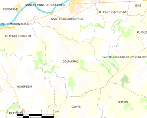
canton of Sainte-Livrade-sur-Lot (canton de Sainte-Livrade-sur-Lot)
- canton of France (until March 2015)
- Country:

- Capital: Sainte-Livrade-sur-Lot
- Coordinates: 44° 24' 0" N, 0° 36' 0" E


- GPS tracks (wikiloc): [Link]
- Wikidata storage: Wikidata: Q1348080
- INSEE canton code: [4730]
Includes regions:
Allez-et-Cazeneuve
- commune in Lot-et-Garonne, France
- Country:
- Postal Code: 47110
- Coordinates: 44° 23' 17" N, 0° 37' 47" E
- GPS tracks (wikiloc): [Link]
- Area: 10.69 sq km
- Population: 590


Le Temple-sur-Lot
- commune in Lot-et-Garonne, France
- Country:
- Postal Code: 47110
- Coordinates: 44° 22' 47" N, 0° 31' 29" E
- GPS tracks (wikiloc): [Link]
- Area: 16.91 sq km
- Population: 1004
- Web site: [Link]


Sainte-Livrade-sur-Lot
- commune in Lot-et-Garonne, France
- Country:
- Postal Code: 47110
- Coordinates: 44° 23' 53" N, 0° 35' 22" E
- GPS tracks (wikiloc): [Link]
- Area: 30.94 sq km
- Population: 6298
- Web site: [Link]

Dolmayrac
- commune in Lot-et-Garonne, France
- Country:
- Postal Code: 47110
- Coordinates: 44° 21' 44" N, 0° 35' 22" E
- GPS tracks (wikiloc): [Link]
- Area: 19.4 sq km
- Population: 710