canton of Selommes (canton de Selommes)
- canton of France (until March 2015)
- Country:

- Capital: Selommes
- Coordinates: 47° 46' 10" N, 1° 11' 11" E


- GPS tracks (wikiloc): [Link]
- Wikidata storage: Wikidata: Q684541
- INSEE canton code: [4123]
Includes regions:
La Chapelle-Enchérie
- commune in Loir-et-Cher, France
- Country:
- Postal Code: 41290
- Coordinates: 47° 49' 28" N, 1° 12' 16" E
- GPS tracks (wikiloc): [Link]
- Area: 10.76 sq km
- Population: 208


Villetrun
- commune in Loir-et-Cher, France
- Country:
- Postal Code: 41100
- Coordinates: 47° 47' 11" N, 1° 9' 37" E
- GPS tracks (wikiloc): [Link]
- Area: 6.83 sq km
- Population: 322
Villemardy
- commune in Loir-et-Cher, France
- Country:
- Postal Code: 41100
- Coordinates: 47° 44' 0" N, 1° 11' 26" E
- GPS tracks (wikiloc): [Link]
- Area: 12.17 sq km
- Population: 280


Rhodon
- commune in Loir-et-Cher, France
- Country:
- Postal Code: 41290
- Coordinates: 47° 45' 12" N, 1° 16' 2" E
- GPS tracks (wikiloc): [Link]
- Area: 7.12 sq km
- Population: 122
Sainte-Gemmes
- former commune in Loir-et-Cher, France
- Country:
- Postal Code: 41290
- Coordinates: 47° 47' 36" N, 1° 16' 15" E
- GPS tracks (wikiloc): [Link]
- Area: 8.56 sq km
- Population: 101


Coulommiers-la-Tour
- commune in Loir-et-Cher, France
- Country:
- Postal Code: 41100
- Coordinates: 47° 46' 59" N, 1° 8' 36" E
- GPS tracks (wikiloc): [Link]
- Area: 12.12 sq km
- Population: 537
Périgny
- commune in Loir-et-Cher, France
- Country:
- Postal Code: 41100
- Coordinates: 47° 44' 25" N, 1° 9' 1" E
- GPS tracks (wikiloc): [Link]
- Area: 10.41 sq km
- Population: 183


Épiais
- commune in Loir-et-Cher, France
- Country:
- Postal Code: 41290
- Coordinates: 47° 48' 27" N, 1° 15' 5" E
- GPS tracks (wikiloc): [Link]
- Area: 8.7 sq km
- Population: 138
Villeromain
- commune in Loir-et-Cher, France
- Country:
- Postal Code: 41100
- Coordinates: 47° 43' 44" N, 1° 8' 35" E
- GPS tracks (wikiloc): [Link]
- Area: 13.08 sq km
- Population: 245
Faye
- commune in Loir-et-Cher, France
- Country:
- Postal Code: 41100
- Coordinates: 47° 48' 8" N, 1° 10' 36" E
- GPS tracks (wikiloc): [Link]
- Area: 8.7 sq km
- Population: 244


Selommes
- commune in Loir-et-Cher, France
- Country:
- Postal Code: 41100
- Coordinates: 47° 45' 21" N, 1° 11' 31" E
- GPS tracks (wikiloc): [Link]
- Area: 28.01 sq km
- Population: 823

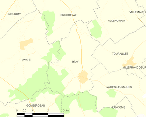
Pray
- commune in Loir-et-Cher, France
- Country:
- Postal Code: 41190
- Coordinates: 47° 40' 34" N, 1° 7' 1" E
- GPS tracks (wikiloc): [Link]
- Area: 10.48 sq km
- Population: 297


Tourailles
- commune in Loir-et-Cher, France
- Country:
- Postal Code: 41190
- Coordinates: 47° 41' 6" N, 1° 9' 31" E
- GPS tracks (wikiloc): [Link]
- Area: 7.46 sq km
- Population: 133
Rocé
- commune in Loir-et-Cher, France
- Country:
- Postal Code: 41100
- Coordinates: 47° 48' 26" N, 1° 8' 51" E
- GPS tracks (wikiloc): [Link]
- Area: 10.27 sq km
- Population: 223
Renay
- commune in Loir-et-Cher, France
- Country:
- Postal Code: 41100
- Coordinates: 47° 50' 34" N, 1° 9' 58" E
- GPS tracks (wikiloc): [Link]
- Area: 12.05 sq km
- Population: 160
Baigneaux
- former commune in Loir-et-Cher, France
- Country:
- Postal Code: 41290
- Coordinates: 47° 46' 56" N, 1° 15' 14" E
- GPS tracks (wikiloc): [Link]
- Area: 6.58 sq km
- Population: 47