canton of Targon (canton de Targon)
- canton in France
- Country:

- Capital: Targon
- Coordinates: 44° 43' 25" N, 0° 12' 39" E


- GPS tracks (wikiloc): [Link]
- Wikidata storage: Wikidata: Q27280
- INSEE canton code: [3348]
Includes regions:

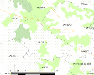
Montignac
- commune in Gironde, France
- Country:
- Postal Code: 33760
- Coordinates: 44° 42' 43" N, 0° 13' 29" E
- GPS tracks (wikiloc): [Link]
- Area: 6.48 sq km
- Population: 154


Lugasson
- commune in Gironde, France
- Country:
- Postal Code: 33760
- Coordinates: 44° 45' 4" N, 0° 9' 37" E
- GPS tracks (wikiloc): [Link]
- Area: 6.32 sq km
- Population: 292

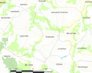
Romagne
- commune in Gironde, France
- Country:
- Postal Code: 33760
- Coordinates: 44° 45' 36" N, 0° 11' 49" E
- GPS tracks (wikiloc): [Link]
- Area: 5.15 sq km
- Population: 450

Frontenac
- commune in Gironde, France
- Country:
- Postal Code: 33760
- Coordinates: 44° 44' 17" N, 0° 9' 44" E
- GPS tracks (wikiloc): [Link]
- Area: 14.4 sq km
- Population: 757
- Web site: [Link]

Martres
- commune in Gironde, France
- Country:
- Postal Code: 33760
- Coordinates: 44° 42' 36" N, 0° 10' 6" E
- GPS tracks (wikiloc): [Link]
- Area: 3.03 sq km
- Population: 116


Saint-Pierre-de-Bat
- commune in Gironde, France
- Country:
- Postal Code: 33760
- Coordinates: 44° 40' 24" N, 0° 13' 48" E
- GPS tracks (wikiloc): [Link]
- Area: 8.95 sq km
- Population: 318
- Web site: [Link]


Courpiac
- commune in Gironde, France
- Country:
- Postal Code: 33760
- Coordinates: 44° 45' 18" N, 0° 10' 56" E
- GPS tracks (wikiloc): [Link]
- Area: 2.21 sq km
- Population: 121
- Web site: [Link]

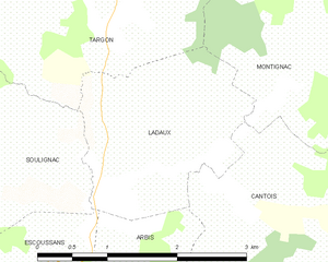
Ladaux
- commune in Gironde, France
- Country:
- Postal Code: 33760
- Coordinates: 44° 42' 2" N, 0° 14' 40" E
- GPS tracks (wikiloc): [Link]
- Area: 4.29 sq km
- Population: 195


Soulignac
- commune in Gironde, France
- Country:
- Postal Code: 33760
- Coordinates: 44° 41' 53" N, 0° 17' 0" E
- GPS tracks (wikiloc): [Link]
- Area: 11.49 sq km
- Population: 435

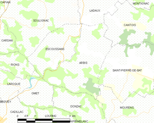
Arbis
- commune in Gironde, France
- Country:
- Postal Code: 33760
- Coordinates: 44° 40' 43" N, 0° 14' 45" E
- GPS tracks (wikiloc): [Link]
- Area: 8.74 sq km
- Population: 277

Targon
- commune in Gironde, France
- Country:
- Postal Code: 33760
- Coordinates: 44° 44' 5" N, 0° 15' 49" E
- GPS tracks (wikiloc): [Link]
- Area: 25.88 sq km
- Population: 2047
- Web site: [Link]


Bellefond
- commune in Gironde, France
- Country:
- Postal Code: 33760
- Coordinates: 44° 45' 58" N, 0° 10' 14" E
- GPS tracks (wikiloc): [Link]
- Area: 3.19 sq km
- Population: 229

Baigneaux
- commune in Gironde, France
- Country:
- Postal Code: 33760
- Coordinates: 44° 43' 22" N, 0° 11' 49" E
- GPS tracks (wikiloc): [Link]
- Area: 7.93 sq km
- Population: 410

Bellebat
- commune in Gironde, France
- Country:
- Postal Code: 33760
- Coordinates: 44° 44' 21" N, 0° 13' 0" E
- GPS tracks (wikiloc): [Link]
- Area: 4.87 sq km
- Population: 235


Faleyras
- commune in Gironde, France
- Country:
- Postal Code: 33760
- Coordinates: 44° 46' 16" N, 0° 13' 37" E
- GPS tracks (wikiloc): [Link]
- Area: 10.44 sq km
- Population: 412


Escoussans
- commune in Gironde, France
- Country:
- Postal Code: 33760
- Coordinates: 44° 40' 58" N, 0° 15' 55" E
- GPS tracks (wikiloc): [Link]
- Area: 5.11 sq km
- Population: 322
- Web site: [Link]

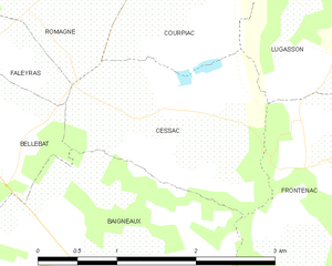
Cessac
- commune in Gironde, France
- Country:
- Postal Code: 33760
- Coordinates: 44° 44' 34" N, 0° 10' 41" E
- GPS tracks (wikiloc): [Link]
- Area: 3.65 sq km
- Population: 189


Cantois
- commune in Gironde, France
- Country:
- Postal Code: 33760
- Coordinates: 44° 41' 35" N, 0° 13' 53" E
- GPS tracks (wikiloc): [Link]
- Area: 8 sq km
- Population: 236

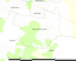
Saint-Genis-du-Bois
- commune in Gironde, France
- Country:
- Postal Code: 33760
- Coordinates: 44° 42' 6" N, 0° 10' 30" E
- GPS tracks (wikiloc): [Link]
- Area: 2.34 sq km
- Population: 91