canton of Tuffé (canton de Tuffé)
- canton of France
- Country:

- Capital: Tuffé
- Coordinates: 48° 6' 37" N, 0° 32' 11" E


- GPS tracks (wikiloc): [Link]
- Wikidata storage: Wikidata: Q1727704
- INSEE canton code: [7232]
Includes regions:
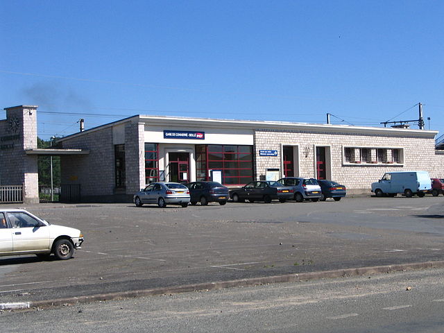

Beillé
- commune in Sarthe, France
- Country:
- Postal Code: 72160
- Coordinates: 48° 4' 59" N, 0° 30' 36" E
- GPS tracks (wikiloc): [Link]
- Area: 8.48 sq km
- Population: 546


Tuffé
- former commune in Sarthe, France
- Country:
- Postal Code: 72160
- Coordinates: 48° 6' 48" N, 0° 30' 52" E
- GPS tracks (wikiloc): [Link]
- Area: 24.66 sq km
- Population: 1531
- Web site: [Link]


Sceaux-sur-Huisne
- commune in Sarthe, France
- Country:
- Postal Code: 72160
- Coordinates: 48° 6' 17" N, 0° 35' 0" E
- GPS tracks (wikiloc): [Link]
- Area: 11.76 sq km
- Population: 570


Vouvray-sur-Huisne
- commune in Sarthe, France
- Country:
- Postal Code: 72160
- Coordinates: 48° 5' 15" N, 0° 33' 2" E
- GPS tracks (wikiloc): [Link]
- Area: 3.34 sq km
- Population: 120
- Web site: [Link]


Prévelles
- commune in Sarthe, France
- Country:
- Postal Code: 72110
- Coordinates: 48° 9' 10" N, 0° 29' 0" E
- GPS tracks (wikiloc): [Link]
- Area: 4.81 sq km
- Population: 218
- Web site: [Link]

La Chapelle-Saint-Rémy
- commune in Sarthe, France
- Country:
- Postal Code: 72160
- Coordinates: 48° 6' 24" N, 0° 27' 23" E
- GPS tracks (wikiloc): [Link]
- Area: 19.2 sq km
- Population: 960
- Web site: [Link]


Saint-Hilaire-le-Lierru
- former commune in Sarthe, France
- Country:
- Postal Code: 72160
- Coordinates: 48° 6' 34" N, 0° 32' 16" E
- GPS tracks (wikiloc): [Link]
- Area: 4.5 sq km
- Population: 142


Le Luart
- commune in Sarthe, France
- Country:
- Postal Code: 72390
- Coordinates: 48° 4' 11" N, 0° 35' 10" E
- GPS tracks (wikiloc): [Link]
- Area: 12.23 sq km
- Population: 1452
- Web site: [Link]

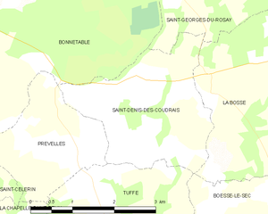
Saint-Denis-des-Coudrais
- commune in Sarthe, France
- Country:
- Postal Code: 72110
- Coordinates: 48° 9' 1" N, 0° 30' 27" E
- GPS tracks (wikiloc): [Link]
- Area: 7 sq km
- Population: 122


Boëssé-le-Sec
- commune in Sarthe, France
- Country:
- Postal Code: 72400
- Coordinates: 48° 8' 6" N, 0° 33' 50" E
- GPS tracks (wikiloc): [Link]
- Area: 11.76 sq km
- Population: 622


Bouër
- commune in Sarthe, France
- Country:
- Postal Code: 72390
- Coordinates: 48° 4' 55" N, 0° 37' 49" E
- GPS tracks (wikiloc): [Link]
- Area: 12 sq km
- Population: 321


Duneau
- commune in Sarthe, France
- Country:
- Postal Code: 72160
- Coordinates: 48° 4' 10" N, 0° 31' 10" E
- GPS tracks (wikiloc): [Link]
- Area: 12.82 sq km
- Population: 1056
- Web site: [Link]

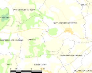
La Bosse, Sarthe
- commune in Sarthe, France
- Country:
- Postal Code: 72400
- Coordinates: 48° 10' 12" N, 0° 31' 34" E
- GPS tracks (wikiloc): [Link]
- Area: 10.75 sq km
- Population: 133