canton of Évron (canton d'Évron)

- canton of France
- Country:

- Capital: Évron
- Coordinates: 48° 9' 25" N, 0° 22' 41" E


- GPS tracks (wikiloc): [Link]
- Population: 21305
- Wikipedia en: wiki(en)
- Wikipedia: wiki(fr)
- Wikidata storage: Wikidata: Q1728072
- Library of Congress authority ID: Alt: [n81044666]
- INSEE canton code: [5306]
Includes regions:

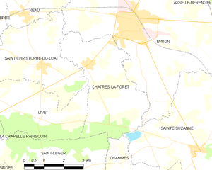
Châtres-la-Forêt
- commune in Mayenne, France
- Country:
- Postal Code: 53600
- Coordinates: 48° 8' 1" N, 0° 25' 54" E
- GPS tracks (wikiloc): [Link]
- Area: 13.6 sq km
- Population: 787
- Web site: [Link]


Voutré
- commune in Mayenne, France
- Country:
- Postal Code: 53600
- Coordinates: 48° 8' 11" N, 0° 17' 27" E
- GPS tracks (wikiloc): [Link]
- Area: 18.57 sq km
- Population: 913
- Web site: [Link]

Neau
- commune in Mayenne, France
- Country:
- Postal Code: 53150
- Coordinates: 48° 9' 22" N, 0° 28' 32" E
- GPS tracks (wikiloc): [Link]
- Area: 12.65 sq km
- Population: 761


Saint-Christophe-du-Luat
- commune in Mayenne, France
- Country:
- Postal Code: 53150
- Coordinates: 48° 8' 1" N, 0° 27' 40" E
- GPS tracks (wikiloc): [Link]
- Area: 19.12 sq km
- Population: 779
- Web site: [Link]


Évron
- commune in Mayenne, France
- Country:
- Postal Code: 53600
- Coordinates: 48° 9' 20" N, 0° 24' 9" E
- GPS tracks (wikiloc): [Link]
- Area: 35.52 sq km
- Population: 7280
- Web site: [Link]


Vimarcé
- commune in Mayenne, France
- Country:
- Postal Code: 53160
- Coordinates: 48° 11' 44" N, 0° 12' 52" E
- GPS tracks (wikiloc): [Link]
- Area: 20.77 sq km
- Population: 241

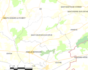
Saint-Georges-sur-Erve
- commune in Mayenne, France
- Country:
- Postal Code: 53600
- Coordinates: 48° 10' 6" N, 0° 17' 53" E
- GPS tracks (wikiloc): [Link]
- Area: 20.17 sq km
- Population: 379


Assé-le-Bérenger
- commune in Mayenne, France
- Country:
- Postal Code: 53600
- Coordinates: 48° 9' 20" N, 0° 19' 14" E
- GPS tracks (wikiloc): [Link]
- Area: 11.68 sq km
- Population: 435


Livet
- commune in Mayenne, France
- Country:
- Postal Code: 53150
- Coordinates: 48° 6' 29" N, 0° 27' 41" E
- GPS tracks (wikiloc): [Link]
- Area: 11.16 sq km
- Population: 147
- Web site: [Link]

Sainte-Gemmes-le-Robert
- commune in Mayenne, France
- Country:
- Postal Code: 53600
- Coordinates: 48° 11' 49" N, 0° 22' 26" E
- GPS tracks (wikiloc): [Link]
- Area: 35.62 sq km
- Population: 876
- Web site: [Link]


Mézangers
- commune in Mayenne, France
- Country:
- Postal Code: 53600
- Coordinates: 48° 11' 28" N, 0° 25' 58" E
- GPS tracks (wikiloc): [Link]
- Area: 29.34 sq km
- Population: 688