Saint-Christophe-du-Luat (Saint-Christophe-du-Luat)

- commune in Mayenne, France
- Country:

- Postal Code: 53150
- Coordinates: 48° 8' 1" N, 0° 27' 40" E


- GPS tracks (wikiloc): [Link]
- Area: 19.12 sq km
- Population: 779
- Web site: http://www.saintchristopheduluat.mairie53.fr
- Wikipedia en: wiki(en)
- Wikipedia: wiki(fr)
- Wikidata storage: Wikidata: Q1100712
- Wikipedia Commons Category: [Link]
- Freebase ID: [/m/03np_wy]
- GeoNames ID: Alt: [6436466]
- SIREN number: [215302076]
- BnF ID: [15264000d]
- VIAF ID: Alt: [316388098]
- INSEE municipality code: 53207
Shares border with regions:

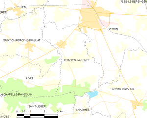
Châtres-la-Forêt
- commune in Mayenne, France
- Country:
- Postal Code: 53600
- Coordinates: 48° 8' 1" N, 0° 25' 54" E
- GPS tracks (wikiloc): [Link]
- Area: 13.6 sq km
- Population: 787
- Web site: [Link]

Neau
- commune in Mayenne, France
- Country:
- Postal Code: 53150
- Coordinates: 48° 9' 22" N, 0° 28' 32" E
- GPS tracks (wikiloc): [Link]
- Area: 12.65 sq km
- Population: 761


Évron
- commune in Mayenne, France
- Country:
- Postal Code: 53600
- Coordinates: 48° 9' 20" N, 0° 24' 9" E
- GPS tracks (wikiloc): [Link]
- Area: 35.52 sq km
- Population: 7280
- Web site: [Link]


La Chapelle-Rainsouin
- commune in Mayenne, France
- Country:
- Postal Code: 53150
- Coordinates: 48° 5' 55" N, 0° 31' 12" E
- GPS tracks (wikiloc): [Link]
- Area: 18.05 sq km
- Population: 417


Brée
- commune in Mayenne, France
- Country:
- Postal Code: 53150
- Coordinates: 48° 9' 2" N, 0° 31' 9" E
- GPS tracks (wikiloc): [Link]
- Area: 16.41 sq km
- Population: 535


Livet
- commune in Mayenne, France
- Country:
- Postal Code: 53150
- Coordinates: 48° 6' 29" N, 0° 27' 41" E
- GPS tracks (wikiloc): [Link]
- Area: 11.16 sq km
- Population: 147
- Web site: [Link]


Montsûrs
- former commune in Mayenne, France
- Country:
- Postal Code: 53150
- Coordinates: 48° 8' 3" N, 0° 33' 13" E
- GPS tracks (wikiloc): [Link]
- Area: 10.85 sq km
- Population: 2035
- Web site: [Link]