canton of Gond-Pontouvre (canton de Gond-Pontouvre)

- canton of France
- Country:

- Capital: Gond-Pontouvre
- Coordinates: 45° 40' 9" N, 0° 9' 51" E


- GPS tracks (wikiloc): [Link]
- Population: 19703
- Wikipedia en: wiki(en)
- Wikipedia: wiki(fr)
- Wikidata storage: Wikidata: Q1725369
- Library of Congress authority ID: Alt: [no2002076674]
- INSEE canton code: [1614]
Includes regions:

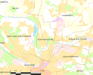
Gond-Pontouvre
- commune in Charente, France
- Country:
- Postal Code: 16160
- Coordinates: 45° 40' 9" N, 0° 9' 58" E
- GPS tracks (wikiloc): [Link]
- AboveSeaLevel: 38 м m
- Area: 7.45 sq km
- Population: 5951
- Web site: [Link]


Saint-Yrieix-sur-Charente
- commune in Charente, France
- Country:
- Postal Code: 16710
- Coordinates: 45° 40' 31" N, 0° 7' 39" E
- GPS tracks (wikiloc): [Link]
- AboveSeaLevel: 175 м m
- Area: 14.65 sq km
- Population: 7206
- Web site: [Link]

Champniers
- commune in Charente, France
- Country:
- Postal Code: 16430
- Coordinates: 45° 42' 54" N, 0° 12' 20" E
- GPS tracks (wikiloc): [Link]
- Area: 45.29 sq km
- Population: 5217
- Web site: [Link]


Balzac
- commune in Charente, France
- Country:
- Postal Code: 16430
- Coordinates: 45° 42' 35" N, 0° 8' 11" E
- GPS tracks (wikiloc): [Link]
- AboveSeaLevel: 40 м m
- Area: 9.64 sq km
- Population: 1329
- Web site: [Link]