canton of Luçon (canton de Luçon)

- canton of France
- Country:

- Capital: Luçon
- Coordinates: 46° 25' 16" N, 1° 13' 52" E


- GPS tracks (wikiloc): [Link]
- Population: 32284
- Wikipedia en: wiki(en)
- Wikipedia: wiki(fr)
- Wikidata storage: Wikidata: Q1726013
- Library of Congress authority ID: Alt: [n86067952]
- INSEE canton code: [8508]
Includes regions:


L'Aiguillon-sur-Mer
- commune in Vendée, France
- Country:
- Postal Code: 85460
- Coordinates: 46° 20' 0" N, 1° 18' 14" E
- GPS tracks (wikiloc): [Link]
- Area: 8.74 sq km
- Population: 2121
- Web site: [Link]


Chasnais
- commune in Vendée, France
- Country:
- Postal Code: 85400
- Coordinates: 46° 27' 36" N, 1° 13' 47" E
- GPS tracks (wikiloc): [Link]
- Area: 10.77 sq km
- Population: 724
- Web site: [Link]

Lairoux
- commune in Vendée, France
- Country:
- Postal Code: 85400
- Coordinates: 46° 26' 52" N, 1° 16' 1" E
- GPS tracks (wikiloc): [Link]
- Area: 13.19 sq km
- Population: 611

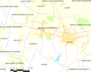
Les Magnils-Reigniers
- commune in Vendée, France
- Country:
- Postal Code: 85400
- Coordinates: 46° 28' 44" N, 1° 13' 13" E
- GPS tracks (wikiloc): [Link]
- AboveSeaLevel: 12 м m
- Area: 17.96 sq km
- Population: 1609
- Web site: [Link]

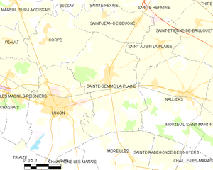
Sainte-Gemme-la-Plaine
- commune in Vendée, France
- Country:
- Postal Code: 85400
- Coordinates: 46° 29' 2" N, 1° 6' 42" E
- GPS tracks (wikiloc): [Link]
- Area: 35.52 sq km
- Population: 2054
- Web site: [Link]


Triaize
- commune in Vendée, France
- Country:
- Postal Code: 85580
- Coordinates: 46° 23' 34" N, 1° 11' 52" E
- GPS tracks (wikiloc): [Link]
- Area: 58.8 sq km
- Population: 1041
- Web site: [Link]

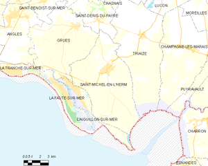
Saint-Michel-en-l'Herm
- commune in Vendée, France
- Country:
- Postal Code: 85580
- Coordinates: 46° 21' 16" N, 1° 14' 55" E
- GPS tracks (wikiloc): [Link]
- Area: 54.8 sq km
- Population: 2362

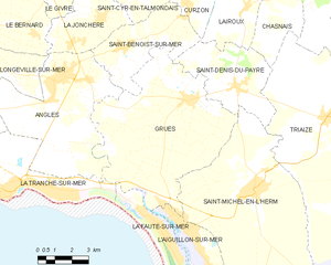
Grues
- commune in Vendée, France
- Country:
- Postal Code: 85580
- Coordinates: 46° 23' 56" N, 1° 18' 16" E
- GPS tracks (wikiloc): [Link]
- Area: 47.18 sq km
- Population: 838


Luçon
- commune in Vendée, France
- Country:
- Postal Code: 85400
- Coordinates: 46° 27' 17" N, 1° 9' 57" E
- GPS tracks (wikiloc): [Link]
- Area: 31.52 sq km
- Population: 9394
- Web site: [Link]


Saint-Denis-du-Payré
- commune in Vendée, France
- Country:
- Postal Code: 85580
- Coordinates: 46° 24' 26" N, 1° 16' 7" E
- GPS tracks (wikiloc): [Link]
- Area: 16.24 sq km
- Population: 384